Winter is returning to New England in a big way. Winter storm watches have been issued for Vermont and New Hampshire, minus southern counties in those states, as well as western Maine. The winter storm watch will likely be pushed south to include all of Vermont and New Hampshire later today. Here's a look at the latest on impact and timing:
NORTHERN NEW ENGLAND IMPACTS

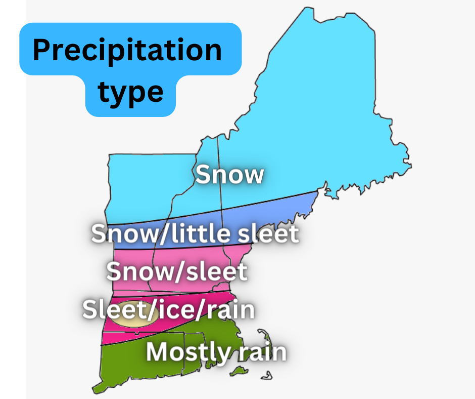
There is still a lot of uncertainty in regards to just how far north the warm air goes. Cold air will drain across the region at the surface, however, warmer air aloft will filter northward. This is a prime setup for sleet. The question is how far north will the warm air aloft get. The area that remains below freezing from cloud to ground will see all snow. These areas will see at least 8 inches of snow, with some places topping out at a foot or more. That NWS of Gray, Maine states:
"Across southern New Hampshire we expect sleet and some freezing rain to develop Wednesday night as warm air aloft advances northward. There is still considerable uncertainty on the northward intrusion of warm air aloft at this time. The NAM is particularly bullish but we can`t discount it since it has done well with temperature profiles in these southwest flow aloft overunning scenarios."
The areas that see the warm air intrusion will see sleet and freezing rain mix in. This will limit snowfall amounts in southern Vermont, southern New Hampshire and York County Maine. These areas will still see snow, but amounts here are looking to top out in the 5-8 inch range. This area has a great deal of uncertainty: how long does it take for the warmer air to filter in? Does the warm air make it at all? How much sleet falls? How much freezing rain falls? The answers to these questions will have big implications on snowfall in central New England.
As you make your way into eastern Maine, you get further away from the storm's center, so, while the storm will be all snow in this area, the snowfall amounts begin to drop off. 5-10 inches is expected across central Maine with 3-6 in eastern Maine.
NORTHERN NEW ENGLAND TIMING
Wednesday night: Snow breaks out from west to east as the night goes on with eastern Maine not getting into snow quite yet.
Thursday morning: The bulk of snow for most of the area, sleet and freezing rain in southern New Hampshire and Vermont mixes in.
Around noon: Heavier snow begins to change to lighter snow showers.
Thursday afternoon: Lighter snow showers continue, snow tapers from west to east.
Thursday evening: Snow begins to pick back up as round 2 begins, will likely mix in central New England. Additional accumulations of 1-4 inches.
Thursday night: Snow slowly tapers off in Vermont and New Hampshire overnight, snow continues all night in Maine.
Friday morning: Snow showers in eastern Maine, the rest of the area drying out.
SOUTHERN NEW ENGLAND IMPACTS
As of Tuesday morning, no alerts have been issued for southern New England regarding this storm. Winter weather advisories will likely be posted either tonight or tomorrow for areas.
This storm is going to be a serious mess in southern New England. Massachusetts, in particular, will be seeing plenty of snow, sleet, freezing rain and plain rain. With the mixing across the area, none of these precipitation types will accumulate to a significant level, but the combination of all the precipitation will create some problems. The NWS of Boston states:
"warm frontal precip approaches from the southwest. Column initially cold enough to support snow per model soundings. However, warm nose invades aloft, around 800-750 mb layer, changing snow over to sleet, with all rain possible for I-95 corridor southeast to the coastline. Then as dry slot overspreads the area later Thu morning into the afternoon, ptype will shift from sleet to freezing rain/drizzle, except all rain likely for the I-95 corridor to the coastline."
A big uncertainty continues to be the prospect of an ice storm in western and central Massachusetts and perhaps northwestern Connecticut. Some models indicate mostly sleet for wintry precip before a change to rain while others show an extended period of freezing rain. To show the uncertainty, some media outlets have up to a quarter inch of ice possible while others don't mention ice at all. A very close eye will be kept on precip type that falls across southern New England throughout Thursday and Thursday night.
SOUTHERN NEW ENGLAND TIMING
Wednesday night: Rain/snow/mix breaks out. There will be more snow than anything right at the start, but as the warmer air lifts, this will change all of southern New England to a mix or plain rain.
Thursday morning: The bulk of the precipitation. Plain rain across Connecticut, Rhode Island and the south shore. Freezing/sleet/mix across the rest of the area.
Around noon: Precipitation begins to taper.
Thursday afternoon: Light mix/snow showers.
Thursday evening: Mixed precipitation picks back up.
Thursday night: Mix likely changes to plain rain showers and slowly tapers off overnight.
Friday morning: Clearing out.
Comments