Winter Ends Spring-Like for New England Before Cooler Storm Arrives
- Tim Dennis
- Mar 19
- 4 min read
New England will remain in a narrow ridge of high pressure between our departing storm system and an approaching one. This high pressure will continue to slide eastward through the day today, increasing an onshore flow. This will create a very standard spring afternoon, with the coastal plain cooling off through the afternoon while areas west and north remain milder all day. Overall, the pitfalls of spring temperatures are in full effect as eastern areas are not reaching the true potential of temperatures given the air mass and setup.

The next system looks to enter the picture Thursday night. A primary low looks to move well north of New England with a secondary low forming near the Mid-Atlantic. This storm currently doesn't look as moisture-packed as the storm earlier this week. The main area to watch will be the potential secondary low development in regards to strength and timing. This will be the main driver of impacts in New England.

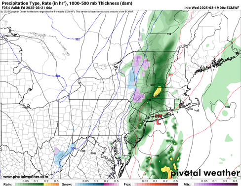
The system will begin as rain for everyone early Friday morning as warm air advects northward ahead of the cold front. As the secondary low develops and tracks northeast near Cape Cod/Gulf of Maine, it will cut off the southerly flow and create a northwest flow, allowing for colder air to filter southward. This should allow for a gradual transition to snow across interior areas on the western edge of the storm.
Below: Euro showing potential weather overnight Thursday into early Friday morning (1st image) and after daybreak Friday (2nd image):
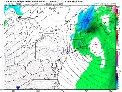
There remains an unusually large spread among guidance in regards to the timing and how progressive the system will be. The main cold front that this will be happening along will get slowed down as it crosses New England due to the blossoming area of low pressure working up the coast. How long it takes for heights to rise behind the storm, allowing for drier air to work into the region beginning Thursday afternoon. The Euro remains the most progressive while the GFS shows a slower movement. The CMC is leaning toward the GFS.
This difference in timing stems from differences among models regarding the evolution of the upper-level pattern. With that said, there has been a general trend toward weaker forcing as a faster flow over the Ohio Valley would allow for drier air to push into the northeast quicker behind the system (as shown by the latest trends within the Euro). Should this trend continue, it would result in a general lowering of precipitation amounts as the system gets kicked out quicker.
Below: Euro vs GFS for Friday evening:
Looking at the secondary, surface low itself as it works up the coast, there are questions regarding how exactly it plays out. While uncertainty continues around the overall timing, there is also a large spread in how a transition from rain to snow will play out. The system will begin as rain for everyone and colder air will get pulled down on Friday. The main question revolves around how quickly the changeover happens and how widespread it will be before precipitation shuts off.
With the system moving through during the daytime, it will need to strengthen a good amount to force the atmosphere to cool enough for snowfall, especially at lower elevations. This deepening would need to happen fairly quickly as well. The storm will need to rely on dynamic cooling of the atmosphere (when a low pressure system is sufficiently strong enough to create a strong upward motion resulting in cooling air and heavy precipitation). There are major reservations about whether this system will be able to achieve this as efficiently as models currently suggest.
With all of that said, we do still expect a transition to snow on the backside of the system. It doesn't look overly impactful in regards to both snowfall and rainfall. At this point, minor accumulations of snow (1-3") appear possible, especially in the higher terrain (Greens, Whites, Maine mountains, Berkshires and maybe Worcester Hills). Any accumulations will be elevation-based. Flakes will have a very tough time sticking at lower elevations (below 1,000 feet). Overall, snowfall amounts have been decreasing within the latest trends.
Below: Current probability of at least an inch of snow by Friday night:

There does remain an outside chance of a brief period of heavier snowfall rates within a narrow band. As of now, this appears most likely to set up over eastern Vermont and western New Hampshire. Yesterday, we said trends on this would be something to watch, and trends are currently heading toward a less favorable environment for this to set up.
After this storm, the next to watch will arrive early next week, likely in the Monday-Tuesday time frame. This system appears to be a "double-barrel" low pressure system that will have a better chance to bring a more widespread early spring snow compared to Friday's system. It will, of course, be elevation based with the potential for valley rain. Trends with this storm could go either way (more wet or more white) at this point, so it's just something to keep watch on the back burner for now.
Below: Current probability of winter weather impacts Monday into Tuesday morning (March 24-25):


Comentarios