The first day of astronomical winter has arrived, and with it has come a blast of cold. The cold air comes as a nor'easter departs to the northeast. This often swings the door wide open for arctic air to pour into New England amid the storm's expansive northerly flow on the backside. Add in a cold Canadian high pressure to New England's northwest, and you have the perfect setup for very cold air to funnel into New England.

Speaking of the nor'easter, it provided a glancing blow with its outer bands as it moved well offshore of New England. A coastal front set up across eastern Massachusetts, allowing for enhanced snowfall rates and 3-6 inches of snow. Six inches was reported at Fenway Park, however, Boston's official snowfall for the record books is taken at Logan Airport. The measurement here has come in at 5.2 inches as of 7am, which means Boston's streak of days without at least six inches of snow will continue. It has now reached 1,030 days.
Below: Snowfall reports (as of writing, Maine has yet to see reports come in):

Today will be cold and windy. Afternoon highs will range from the low 20s north to low 30s south, but blustery winds will knock feels-like temperatures down to the single digits and teens today. Winds will remain elevated overnight into Sunday morning. With low temperatures dropping to the single digits, on either side of zero, and a continued breeze, most of New England will see wind chills drop below zero, with the higher elevations dropping into the -10 to -25° range.

A cold weather advisory has been issued for Berkshire County. This alert is new for this year and replaces the old wind chill advisory. This was done so alerts could be posted when just the air temperature drops below the threshold for an alert without any wind. Wind chill advisories could only be issued when the wind directly contributed to the cold.
The threshold for this alert is air temperature or wind chills dropping to -10° across Connecticut, Rhode Island and southeast Massachusetts. The rest of southern New England has a threshold of -15° while northern New England has a threshold of -20°. Cold weather advisories may be expanded later today. For the record, wind chill warnings have been replaced with extreme cold warnings. This was a nation-wide change.
The coldest day of this stretch will be Sunday under a strong Canadian high pressure. Temperatures around 5,000 feet will be in the -5 to 0° range, which will support surface highs in the low teens across the north to low 20s in southern New England. With high pressure building in, winds will slacken, but may still be noticeable.
Sunday night will be very cold, with single digits, on either side of zero, likely across the entire region. Sunday night into Monday morning may be the colder of the nights due to optimal radiational cooling conditions under the high pressure, allowing for light winds and clear skies. Lows in the -10s will be possible across the north.

Monday will remain cold with temperatures likely moderating back toward more seasonable levels on Christmas Eve. Another clipper system may be on the docket for Christmas Eve. Clipper systems have been the dominant winter storm type so far in this young winter season for New England. Timing of this system has continued to trend earlier. Guidance is beginning to agree that the system will pass through New England Monday night into Tuesday.
This clipper is poised to bring some light snow showers to New England during the daylight hours on Christmas Eve. This does not look like a major event and will likely provide light accumulations or festive flakes flying for the holiday. At this point, accumulations of 1-3 inches seems like a reasonable assumption at this point. Where this would set up over New England will be dependent on the system's track. This will be an all-snow event for most, however the coast could see some rain showers depending on the low's track.

After this system, a pronounced ridge currently looks to settle over New England. This is currently poised to bring mainly dry weather to the region for the remainder of the week. Christmas Day/start of Hanukkah itself continues to look rather quiet and seasonable. Broad cyclonic flow may linger after the clipper, resulting in increased cloud development and the potential for quick, pop-up showers, however.
Below: Current weather map for Christmas morning:

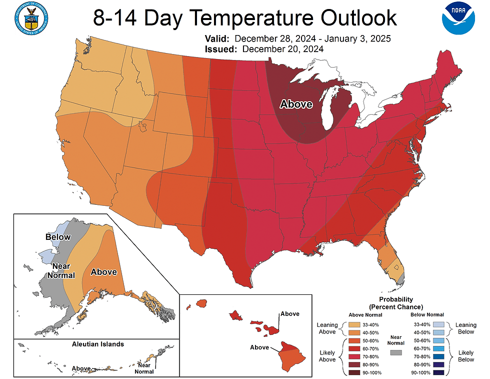
Looking at the rest of the calendar year, broad ridging is generally expected, leading to the likelihood of above average temperatures for much of the United States. Locally, New England currently has a 60-80% chance of generally above average temperatures from December 28 to January 3.
Commentaires