Warming Trend, Unsettled Weather Coming to New England After Weekend
- Tim Dennis
- Jan 20, 2024
- 2 min read

Updated: Jan 21, 2024
As we've been writing about all week long, this cold snap will end at the start of next week, with temperatures jumping above average in places by Monday or Tuesday, depending on where you are in New England. The caveat in the temperatures will be a weak cold front dropping through northern areas on Tuesday. This may keep much of Maine a bit cooler through Wednesday.

This warming trend will come with a return to unsettled weather after a mainly dry weekend and start of the work week. Starting on Tuesday night, high pressure to New England's north will push cooler air into northern New England while high pressure to the south will push warmer air into southern New England. This sets up a baroclinic zone over New England.
A baroclinic zone is an area where a temperature gradient exists in an area of constant pressure (i.e. two areas of high pressure advecting warmer and cooler air into New England). This, along with a weak shortwave disturbance aloft, will allow precipitation to break out in New England Tuesday evening and continuing through Wednesday.

All of that is to say some light to steady steady snow and rain showers will be possible Tuesday night and Wednesday (we like to go into the "why" around here, not just the "what"). With this temperature gradient, the precipitation type is a bit tricky. Much of New England may see snow showers Tuesday night before a switch to mixed precipitation and rain by Wednesday morning.
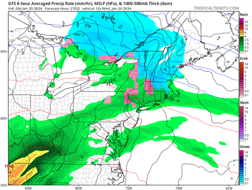
There's a split in models in how far south the cooler air will push. Right now, it does look like enough cooler air will sink southward for all of New England to see snow at least for Tuesday night before switching by Wednesday afternoon. Either way, this is a weaker disturbance that will likely provide lighter snowfall and accumulations. Any more details will have to wait until we get closer to the event.
Euro vs GFS for Wednesday morning. Euro has a cooler solution while GFS brings more mild air into southern New England:


The front partially responsible for Tuesday night to Wednesday's precipitation will remain stationary to the south of New England through Thursday. This will provide a lot of clouds and occasional showers for much of New England. Maine will likely be the driest during this time frame.
Another storm will likely move through the region Thursday night through Friday. This could provide a more steady rain or snow event. Early indications show a more mild event with mainly rain in southern New England and potentially a snow to mix transition in northern areas.
This is far from locked in as another area of high pressure over Quebec could feed cooler air into northern New England, leading to a more wintry system. As usual at this range, we need to keep an eye on the trends as confidence in this system is low at this time.
What the Euro model currently shows for Friday morning. This could trend colder depending on how the setup plays out:


Comments