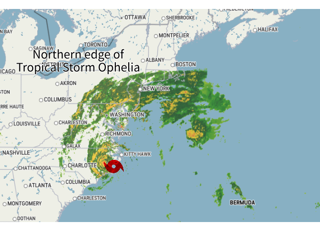
Tropical Storm Ophelia has made landfall in North Carolina this morning. The northern edge of the storm has begun to push into southern New England Saturday. The system as a whole will slowly push north, leading to an unsettled few days.
TODAY
With New England just getting into the northern edge of the storm, rainfall will be greatest along the south coast, with gradually less and less rain the further north in New England you go. Showers will likely break out in southernmost New England early Saturday morning, with a steadier rain beginning in the late morning or afternoon.
Areas of New England south of the Mass Pike are certain to see a steady rain today, with a half an inch to an inch of rain possible. Further north, there will be considerably less rainfall. The storm will be battling dry air in these areas, and it will be difficult for the rain to fall north of the Mass Pike. Once you get to the MA-NH and MA-VT borders, the storm will be hard-pressed to create much rain at all.

As for temperatures, it will be a bit of a backwards day for New England with the lowest temperatures in southern areas and gradually warming as you head north.The northern tier of New England will likely make it to 70° thanks to some sunshine. Southernmost New England will struggle to get out of the 50s thanks to the thick clouds, rain and breezy weather.
Speaking of breezy weather, there will be gusts of 25-35mph in southern New England. While this isn't damaging, it will certainly add to the very raw feel of the day.
SUNDAY
The unsettled weather will continue as the system very slowly pushes northward. As it does so, it will begin to fall apart, and will revert back to a subtropical (or post-tropical) system.
The system won't be potent, but clouds will linger and occasional showers will occur throughout the day. Like Saturday, these showers will likely be limited to southern and central New England, with northern areas remaining dry. The chance for the most showers will be in southwestern New England.
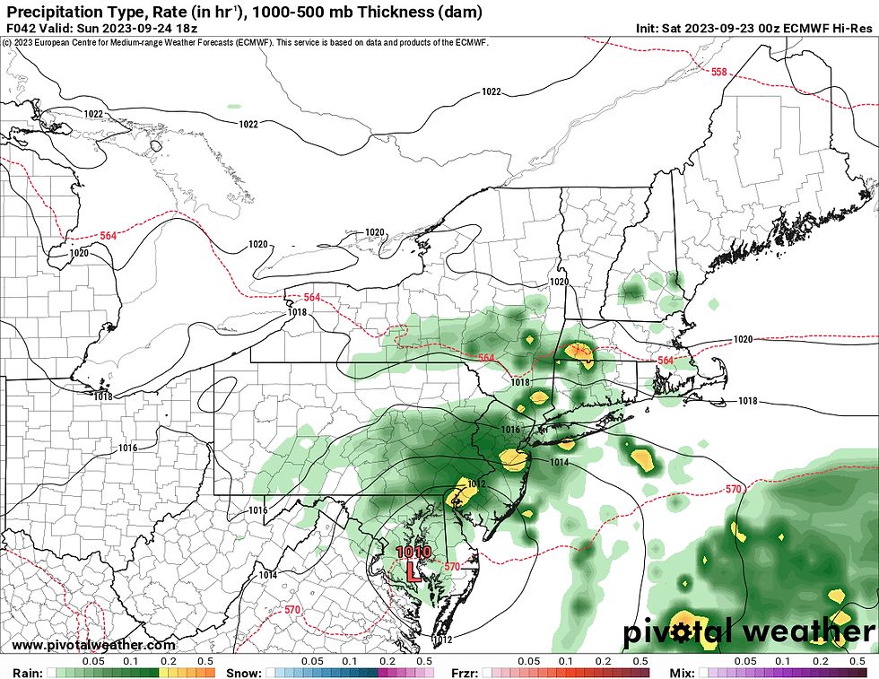
There will be a chance for some showers to become moderate to heavy in intensity on Sunday, mainly in southwestern areas of New England, closer to the center of the storm. There is still some discrepancy in overall coverage and timing of the showers. The takeaway from this is to expect on and off showers scattered around southern and central New England throughout Sunday. It certainly won't be raining all day, but the chance of rain will exist all day.
Euro Model showing scattered showers around Sunday afternoon, mostly in southwestern areas. You can also see the model picking up on the possibility of some heavier downpours:
Sunday will remain breezy and raw for southern and central New England with highs in the low to mid 60s. The northern tier will again escape the rain, with mostly cloudy skies and temperatures in the mid 60s to low 70s.
MONDAY
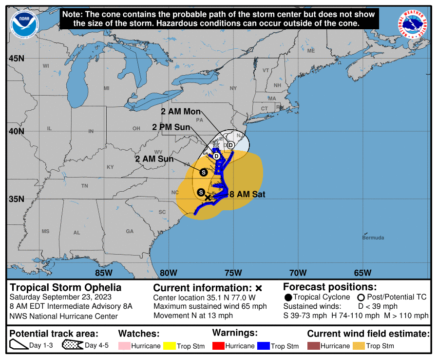
The remnants of Ophelia are looking to pass to New England's south Sunday night and Monday. This will lead to continued showers Sunday night and maybe into Monday morning. The showers should shut off from west to east as the system pulls away.
As of now, this exit has sped up, meaning by Monday afternoon, skies are looking to become partly cloudy to mostly sunny. Northern New England will once again be dry Monday from beginning to end.
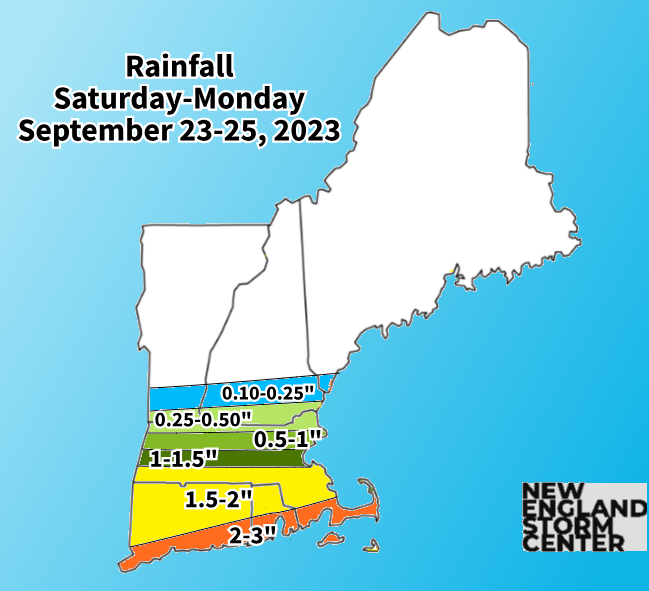
When all is said and done with Ophelia and her remnants, areas south of the Mass Pike will likely end up with 2-3 inches, with a sharp cutoff in rainfall totals once you get north of the Pike. Flooding isn't a major concern as this rain will be falling over the course of two and a half days.
BEYOND
After the system exits, high pressure is looking to build back into New England from Canada. The atmosphere will be dry, even by early fall standards, so after we get rid of this subtropical storm, New England will be looking at dry weather for the rest of the week.
Canadian high pressure dominates New England's weather next week, this will lead to very fall-like weather:

High temperatures are looking to be mainly seasonable during this time frame. With Canadian high pressure in place along with calm, mainly clear conditions, morning lows will have the chance to be pretty chilly. These lows will drop into the 40s to low 50s. Some mountain towns may be able to drop into the upper 30s. Some northern areas may see the first frost advisories of the season next week.
These cool nights and warm days will help get fall foliage rolling in northern areas next week.
Comments