A storm system will be traversing New England during the day on Thursday. While this storm will be weak and precipitation will be generally light and scattered, it will still create a cold and raw day for everyone. With the storm's expected setup, there is a chance for all precipitation types across New England (rain, snow, sleet, freezing rain and graupel).
The storm's leading edge will likely enter into western New England early Thursday morning. This initial onset of precipitation will likely be cold enough for a wintry mix or snow in all of western New England, however, lower elevation areas of southern New England will likely switch to plain rain rather quickly as the storm progresses eastward. Areas of northern New England that initially start as snow will likely transition to a wintry mix or ice by sunrise Thursday.
Expected weather early Thursday morning (1st image) and around sunrise Thursday (2nd image). You can all rain showers in southern New England by sunrise with a wintry mix and snow persisting in northern New England:


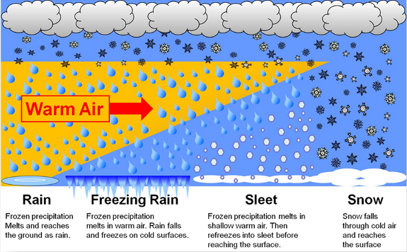
The storm's overall setup lends itself to this being one of those "messy mix" type of storms. Cold air has been put in place over New England thanks to a rather strong cold front that is dropping through New England today (Tuesday). As this storm approaches, it will tap into that cold air, however, a warm front will lift through the region over the cold surface air. Whenever you have warm air lifting over a cold surface, it is prime for a variety of precipitation types.

Southern New England and southern New Hampshire will see primarily rain (after a quick onset of frozen precipitation) as the temperature at the surface climbs well above freezing by Thursday morning. Areas of northern New England may remain below freezing at the surface into the afternoon. This would lend itself to freezing rain and some icing depending on how deep the warm layer of air is aloft.
By Thursday afternoon, most of New England will likely have switched over to plain (but cold) rain, except for the higher elevations of northern New England. This is also when the storm will begin to enter into Maine, with snow showers across the interior and rain showers closer to the coast. Maine will likely see the least amount of precipitation from the system.
Expected weather Thursday afternoon. This precipitation will be light and more scattered around:

The storm will be quick hitting and likely pulling away by Thursday evening for most of New England. As stated in the beginning, this is a weak storm and precipitation will generally be light and more scattered around. This will not be a high-impact storm, with any snow accumulations likely remaining under 2 inches and any ice accumulations remaining under a tenth of an inch. Rainfall will also be light, likely remaining under a half an inch.
The first image below is a probability of at least a tenth of an inch of ice accumulation. The highest chance in New England currently tops out at a measly 20% in southern Vermont and the northern Berkshires. The 2nd image is a probability of at least two inches of snow accumulation. Chances in northern New England remain below 50%:


Thursday will be cold, raw and damp all day, with highs topping out in the 30s north to low 40s south. The region dries out on Friday, but it will remain chilly through the weekend.
Comments