In a setup very similar to Halloween, an area of low pressure is currently lifting its warm front through New England this morning. At the same time, an area of high pressure continues to move farther offshore. This high really limited temperatures on Monday as it produced an onshore flow off the chilly Gulf of Maine. With New England now re-entering a warm sector, another bout of near record warmth for the time of year will be ushered in.

While the day is starting off cloudy and showery (for some), a clearing trend will commence once the area becomes firmly within the warm sector. These morning clouds will limit daytime heating initially, but afternoon breaks in the cloud cover should allow temperatures to soar well above average this afternoon. Just how mild it gets today will depend on how soon and how often the sun can break out, especially since the sun sets before 5pm now. Southern areas are already starting to see clouds break this morning.
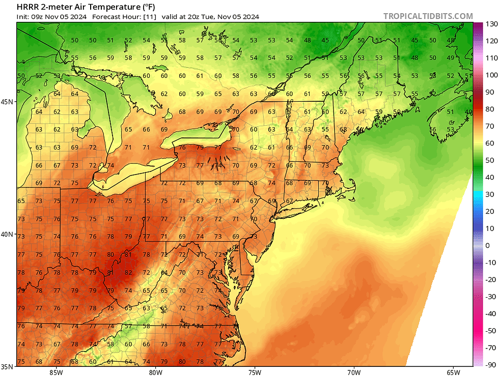
Temperatures should be able to rise into the 60s for many today. Low to even mid 70s will be possible across the typical warm spots of southern and central New England (the river valleys) and eastern Maine will likely get held to the 50s as the warm front arrives later in the day. Even if clouds were stubborn and hung around, the increasing westerly flow will create a downsloping effect off the western New England mountains and would still allow temperatures to rise well above average today.
Below: HRRR showing potential temperatures around 3pm today:

The warmth will peak on Wednesday as the region will firmly be within the system's warm sector. Along with this, a strong southwesterly flow ahead of the system's cold front, very mild temperatures aloft with good mixing and a ridge to New England's south, widespread 70s will be likely with mid to upper 60s for the northern third of New England.
The aforementioned system to the north will drag its cold front into northwest New England on Wednesday morning and will continue to push south and east during the day. Much like last week, however, the cooler air will lag behind the front, so all of New England will still see a very mild day.

The cold front will likely kick off scattered showers across the northern tier of the region in the morning. These showers will be very light and scattered. The showers will dry up as they push southward later in the day. These showers and clouds will play a role in just how mild it can get for Wednesday.
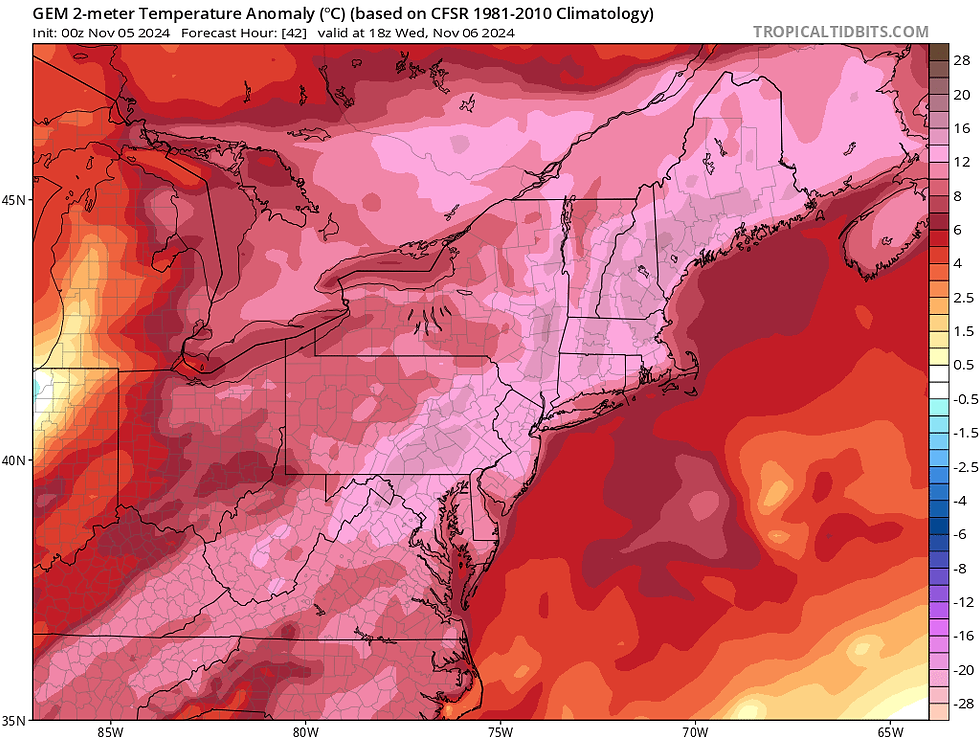
It'll be mild regardless of clouds, but the amount of cloud cover could be the difference between hitting daily record high or not. Widespread 70s are likely across much of New England with 60s in the higher terrain. The Lower Connecticut River Valley and Merrimack Valley could try to make a run toward 80°, though actually achieving this will be very difficult given the short days. The very dry soils will make it easier to heat up for southern New England then it otherwise would be in this setup at this time of year.
Below: Temperature departure from average for Wednesday afternoon showing temperatures 12-16° above seasonal averages:

The breezy, dry and very warm conditions will once again lead to high fire risk across southern New England, both today and Wednesday. A Red Flag Warning was not posted for Tuesday due to winds not meeting the criteria, but gustier winds tomorrow may lead to one being posted for Wednesday in southern New England. Whether one is posted or not, elevated fire risk will continue every day until a soaking rain comes. Current fires will continue to burn and smolder this week (and likely beyond).
Temperatures have been very up and down for basically the entire fall. While ups and downs are expected in a transitional time of year, the ups and downs this season have been drastic at times. This can be attributed to how dry it's been. A dry ground can heat up (and cool down) much quicker than a saturated one. With how dry the soils have been, especially for southern New England, it has made the region highly susceptible to large temperature swings. Given the time of year, these swings have been very noticeable.

The dry ground also limits how much evaporation can occur since there is little moisture to evaporate within the soil. This can limit shower activity, which is why showers have been weakening and drying up as they approach southern New England over the past couple weeks. New England needs a juicy storm to soak the ground. The lack of evaporation also limits the amount of cooling that can occur, aiding in the temperature spikes seen over the past couple weeks when the overall setup is favorable for warmth (like the next two days).
As far as rain chances go in the long run for New England, things continue to point toward a chance of beneficial rainfall late this weekend into early next week. A potent low pressure system is currently looking to track into the Great Lakes this weekend and then north of New England. Depending on how this plays out, enough moisture and forcing may be present to bring southern New England a period of badly needed rain. Whether the system and its ingredients will be able to line up to bring this remains to be seen, but the chance is there.
Below: Current weather map for Monday morning (November 11):

Comments