The Factors Behind Vermont's Extreme Rainfall Event
- Tim Dennis
- Jul 30, 2024
- 5 min read
In the early morning hours of Tuesday, July 30th, an extreme rainfall event took place across Vermont's Northeast Kingdom. This event dropped upwards of eight inches of rain across the region in a span of less than six hours. Furthermore, St. Johnsbury saw nearly a half foot of rain in just three hours. Unlike recent flooding events in Vermont, the severity of this one was not expected. Here's what led to this unexpected severe flash flooding event.
The main factor behind this event was the formation and movement of a cutoff low. This low pressure system emerged from the southeast United States coastline this past weekend. The system was weak and quickly became cutoff, meaning it was detached from the main flow. These cutoff lows can be difficult to track since there's no strong steering current for the storm and it can basically "do whatever it wants."
When this system came off the southeast coast, it was steered northward due to a strong ridge of high pressure on either side of it. In a forecast post on Saturday morning, we wrote: "Instead of shooting out to sea, this low will meander up the east coast, passing offshore of New England later Sunday into Monday. This low is being steered north due to the high pressure over the northeast and in the open Atlantic."
A graphic we used in the Saturday forecast post showing the low pressure system flanked by high pressure on Sunday. This forced the storm to the north and eventually westward into the Gulf of Maine by Monday:

During the day Monday, the system remained weak. The low slowly meandered its way through New England during the day, continuing to move generally northward as it did so. The system was also rather compact in nature, which is why it was rather unassuming. For most of New England, the main impact from the system was the fact that it basically hit the pause button on summer, bringing cool, damp and dreary conditions for one day.
This system was a coastal storm more typical of the October-April time frame, similar to a nor'easter. Nor'easters have a difficult time forming in the summertime, but in the end, they can form whenever the conditions are right, anytime of the year. While this low remained weak and not impactful for most of New England, the Northeast Kingdom was in the unfortunate position where a variety of other factors came into play.
Satellite loop from Friday through Monday showing the storm's track over the ocean, pivoting northwest ward and eventually northward through New England:

First and foremost, the system created strong upper-level divergence (when winds move away from the center). To get upper-level divergence, you must have low-level convergence from an area of low pressure (winds converge, or come together, on low pressure). The converging air rises and then diverges in the upper levels. Divergence at the upper-levels enhances the lift, which allows for storm development.
In this case, it allowed storms to maintain themselves well after dark. Typically storms will weaken and fall apart after sundown due to the lack of daytime heating. This process also allowed the system to intensify becoming abnormally strong for the time of year.
Chart showing how the system intensified from strong upper-level divergence:

This is why storms persisted all night long, but more is needed to get the extreme rainfall rates that the Northeast Kingdom saw. In this case, the atmosphere was incredibly moisture-rich, as it has been for most of July. Storms were quickly able to take full advantage of the humidity in the air and produce intense rainfall rates.
Unfortunately, as with most cutoff low pressure systems, everything was very slow moving. Winds in the atmosphere were very light, and without a strong mode of forcing for rainfall to move along, storms nearly sat in place where they formed, which was over the Northeast Kingdom and into the White Mountains.
The final nail in the coffin was the development of storm training. Not only were storms slow moving, but multiple storms moved over the same areas for several hours. Storm training also goes back to the strong upper-level divergence. This factor allowed for many storms to continue to thrive in the same areas rather than fizzling out.

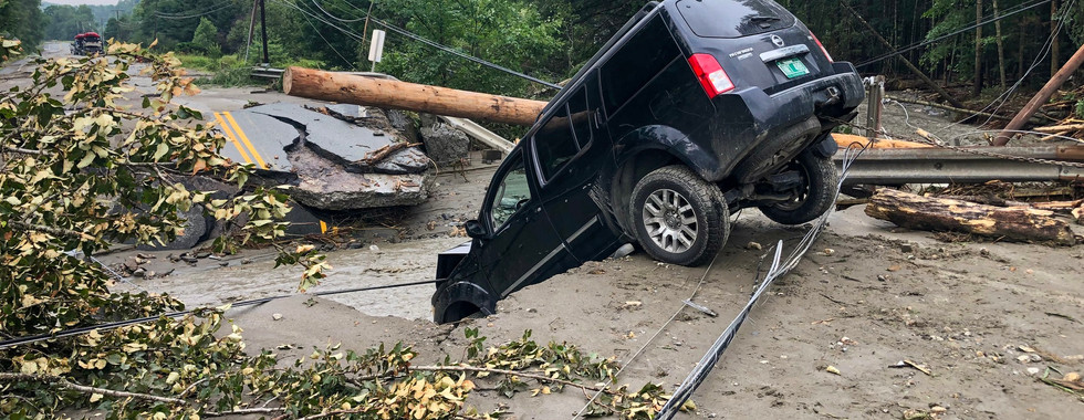
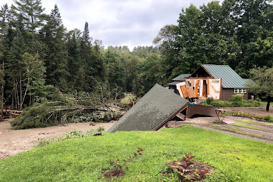
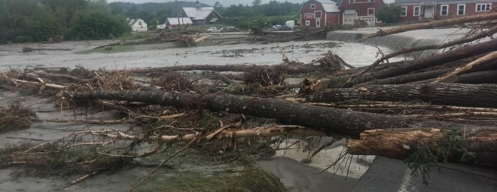
All of this combined to create a localized, but devastating flash flooding event for the Northeast corner of Vermont. Early Tuesday morning, multiple flash flood warnings were issued along with two flash flood emergencies. Flash flood emergencies are rare alerts issued only for the most extreme of flooding events. These were only the second and third such alerts ever issued for Vermont. The first was during the Great Flood of 2023.
St. Johnsbury was the epicenter of this flood. The town saw over eight inches of rain total. The flood in the town has surpassed the threshold for being considered a 1-in-1,000 event, meaning there is a 1-in-1,000 chance (or 0.1%) of everything lining up to create a flooding event of this magnitude in any given year. This event shattered rainfall records for the town.


Photos: Vermont State Police; Lyndon Rescue
ST. JOHNSBURY AND LEOMINSTER
What occurred with St. Johnsbury was very reminiscent of what occurred in the city of Leominster, Massachusetts on September 11th, 2023. That evening, a stalled thunderstorm dropped over nine inches of rain on the central Massachusetts city, causing catastrophic flooding, severe road, home and business damage as well as resulting in numerous water rescues.
What's interesting about the Leominster and St. Johnsbury flooding is the compact nature of the extreme rain totals. Leominster's neighbor Lunenburg saw over 2 inches less while neighboring Fiychburg saw around 4 inches less. Last night, there was a very sharp cutoff in rainfall totals to the west, with amounts quickly dropping to an inch or less. Even moving northward, parts of Lyndon reported several inches less than St. Johnsbury (though Lyndon was still hit hard by flooding). North of Lyndon, the town of Burke reported over 5 inches of rain.
Rainfall reports from last night:

This shows the very varied nature of the deluge, similar to the September floods, where two distinct areas of the heaviest rain occurred, one over Leominster and the other near the Massachusetts-Rhode Island border. The setups between these two events can't really be compared as they are very different, but the magnitude of both events were unexpected.
Flash flooding was more expected in the September event, with the Weather Prediction Center placing much of southern and central New England in the "slight" category (level 2 of 4) for excessive rainfall. Last night, Vermont was only in the "marginal" category (level 1 of 4). For comparison, the flooding earlier in July saw Vermont in the "moderate" category (level 3 of 4) while the July 2023 floods saw Vermont in the "high" category (level 4 of 4).
Commentaires