For the next week or so, New England will be firmly embedded under a rather strong and expansive area of higher pressure. This will bring about a stretch of mainly sunny, quiet and mild days across the entire region. This high pressure, in all likelihood, will give portions of New England it's last string of 70° temperatures. For interior southern New England and the valleys of northern New England, widespread highs in the upper 60s to mid 70s will be likely from Saturday through the middle of next week.
A mild air mass aloft combined with surface high pressure to New England's southwest (along with sunny skies) makes for a favorable setup for temperatures to shoot up once the sun rises. This high pressure system over New England will be on the stronger side, around 1,035 millibars. For comparison, neutral pressure (neither high nor low) is around 1,013 millibars.
Below: Pressure Saturday morning:

Conditions will also remain favorable for chilly mornings. For temperatures to bottom out overnight, there needs to be a lack of humidity, calm winds and clear skies. With a strong area of high pressure overhead, all three of these conditions will be present. Widespread morning lows in the 30s to low 40s will continue through Sunday morning. That means it will take time to reach the upper 60s and 70s in the afternoon, but it should get there under favorable conditions.
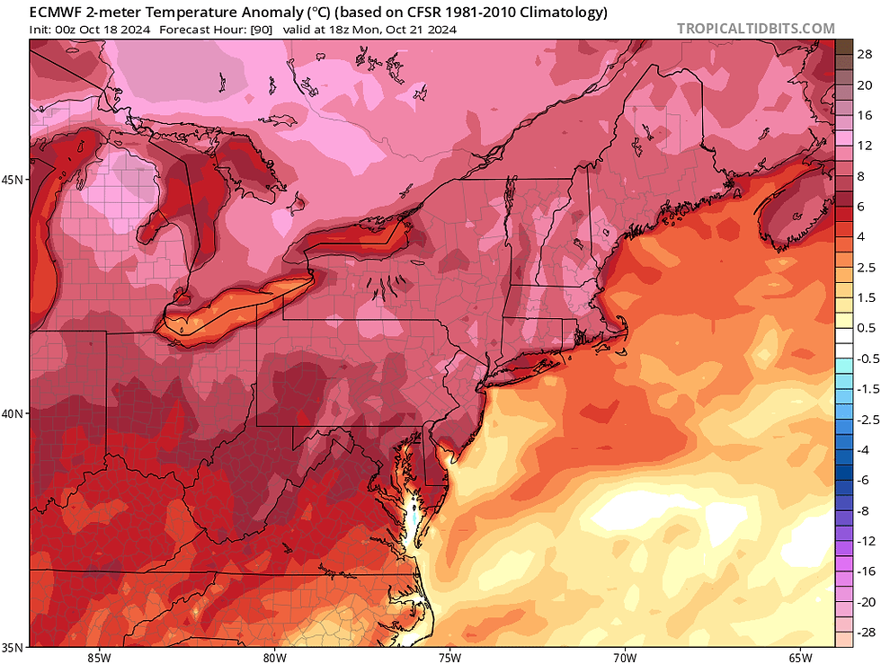
The warmest day of the stretch is shaping up to be Monday. Winds will be most westerly on Monday, which could result in a minor downsloping effect off the higher terrain of western New England, which would help the air moving eastward to warm up. This is the main reason why Monday may be a notch warmer than the rest east of the mountains. Sunny skies will prevail through the weekend and right into early next week.
Below: Temperature departure from average on Monday afternoon. Note the highest temperature departure is east of the higher terrain of western New England. That is the minor downsloping effect in action:

With these tranquil conditions, the main weather story through the weekend will be the potential for some minor "sunny day" flooding along the coast. Tides will be astronomically high through the weekend, which will push coastal gauges to near minor flood stage alone. A distant coastal storm’s blustery northeast winds may push some flood prone areas over the edge and lead to minor sunny day flooding at high tide.

With the high pressure keeping that coastal storm well offshore before being pushed out to sea completely, New England will not be seeing the likes of any kind of storm or system for several days. The ridge of high pressure will keep northern stream systems well to the north of New England. Early next week, one of these systems will travel well to New England's north, so much so that the system's trailing cold front won't be able to push through the region.
Below: 500mb height anomaly showing the deep ridging over the northeast with troughing kept across northern Canada:

This ridge does show signs of breaking down heading into the middle or latter part of next week. This would allow a frontal system to sweep across the northern Great Lakes and eventually into New England. Wednesday to Thursday will be the next shower chance for New England. With that said, this system will likely have meager moisture to work with, so shower activity may be quite limited. The more noticeable impact may be a return to more seasonable temperatures.
Below: Current Weather Prediction Center 7-day rainfall forecast:

Kommentarer