New England's winter storm will be working up the east coast throughout today. The storm will very likely track between Cape Cod and the benchmark on Sunday. This will result in higher snow totals across the interior with lesser amounts as you work toward the coast. With cold air rushing into the system from the north, you won't have to get too far from the coast to get into all or mostly snow.
Radar as of 6:45pm:

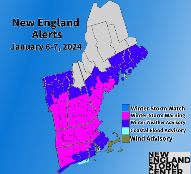
ALERTS
TIMING
The daylight hours of Saturday will be dry for just about everyone. Snow showers will begin to move in from southwest to northeast throughout Saturday evening and into the night. There could be some ocean-effect snow showers in the afternoon across eastern Massachusetts and southeast New Hampshire, but this won't amount to much.
Expected weather Saturday evening:
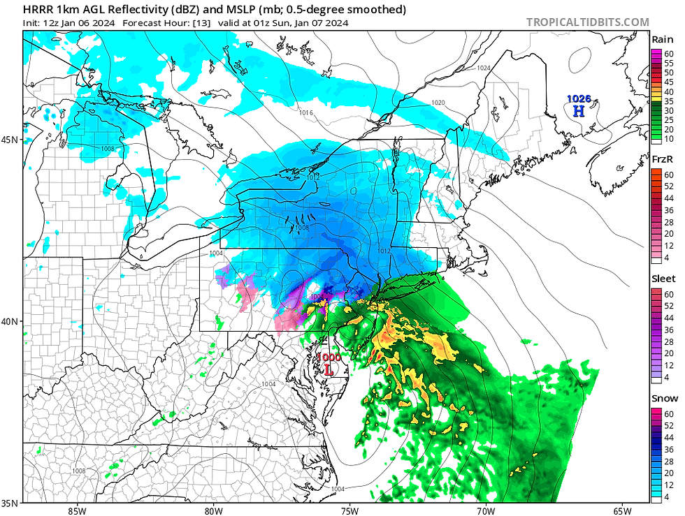
The snow will ramp up in intensity as we work deeper into the overnight hours. Snowfall rates will likely reach their most intense rates, up to an inch to an inch and a half an hour, during the early morning hours of Sunday. These rates will be most common across southern Vermont, southern New Hampshire and interior Massachusetts, particularly Worcester County. Eastern Massachusetts, Rhode Island and coastal Connecticut will likely see rain and/or mixing at this time.
By around sunrise, the most intense snowfall rates will begin to back off. There will likely be a bit of a lull Sunday morning during the daylight hours. During this time, there will still be rain/mixing going on across eastern Massachusetts and Rhode Island. Just how far inland/north the rain/snow line makes it will play a large role in total snowfall. Right now, it looks like Sunday morning will be the warmest part of the day when the rain/snow line makes its furthest advance. The storm will be all snow for all of northern New England.
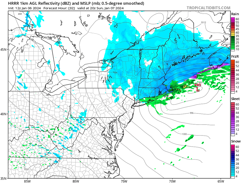
Expected weather early Sunday morning (1st image) and around sunrise Sunday (2nd image):


By Sunday afternoon, snow will likely begin to fill back in, at an overall lighter rate. This will occur as the storm will undergo intensification as it passes offshore to the east of New England. Exactly when this intensification occurs will have a role on snowfall rates Sunday late morning and into the afternoon.
The areas that will have the best chance at seeing more moderate snow at this time will be eastern Massachusetts, southeast New Hampshire and coastal Maine. If the intensification happens further east, snow will remain lighter through all of New England Sunday afternoon. Temperatures will also crash Sunday afternoon, collapsing the rain/snow line southward throughout the afternoon.
Expected weather mid-afternoon Sunday:
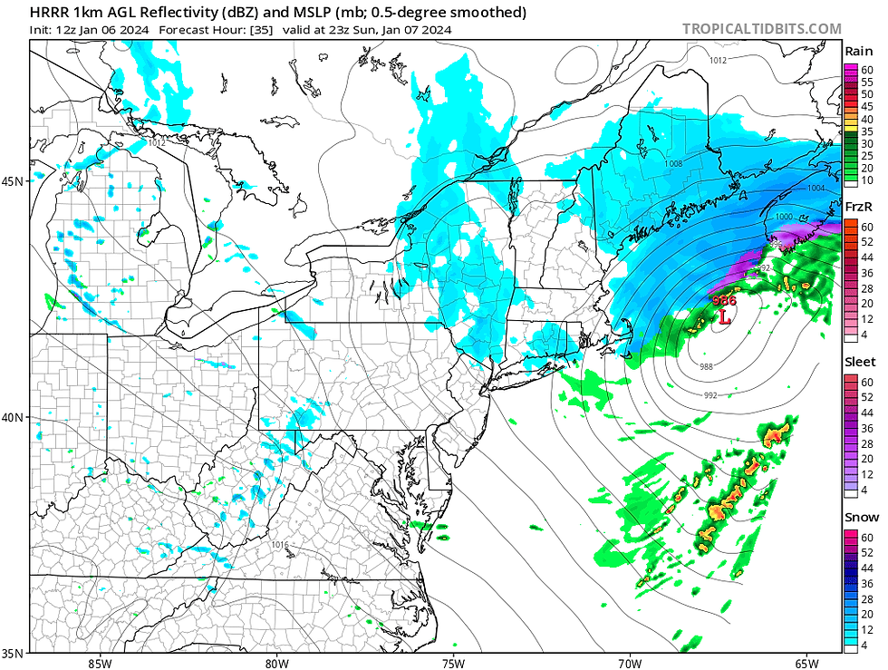
By late-afternoon, all of New England will be below freezing and everyone will be seeing snow showers. The storm will begin to wind down Sunday evening as the storm pulls away. Maine will remain in the snow for much of the first half of Sunday night.
Much of New England will see much of their accumulation in the first wave in the early morning hours of Sunday. The exception will be eastern Massachusetts from Boston southward, Rhode Island and southern Connecticut. These areas will see their most snow Sunday afternoon after the cold air rushes in. Maine will also see their (light) accumulations Sunday afternoon.
Expected weather Sunday evening:
SNOW
The jackpot zone for this storm continues to look like it will be southern New Hampshire, southern Vermont and interior Massachusetts and Connecticut. These areas will stand the best chance at seeing a half foot or more of snow. Most towns and cities in these areas will likely see 6-10 inches of snow with up to a foot where the heaviest snow bands set up.
Our main change to our snowfall map from yesterday evening was to adjust the 8-12 inch zone to include more of Rockingham County, New Hampshire and push it further south into Worcester County, Massachusetts. We also pushed the 5-8 inch zone to include more of the Green Mountains.
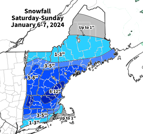
Heading toward eastern Massachusetts and the south coast, things get a bit questionable. Snowfall amounts will very likely be lower there due to initial rain and mixing. The snow itself will also be the heavier, wetter kind, which compresses as it accumulates (it also likes to melt on contact), making it more difficult to pile up. The further north in New England you go, the lighter and fluffier the consistency of the snow will be.
Colder air from the north will likely rush into these areas as the winds shift to the north, which will gradually change rain and mixing over to snow. How quickly this happens will be key in the final snowfall totals in eastern and coastal areas of southern New England.

When the storm deepens will play a role in the intensity of the snow. Should the system not deepen until its well east of New England, lighter snow would be seen in New England. This would result in a bit lower snow totals across the interior. This is the main way the storm could bust.
The northern tier of New England will remain well away from the storm's center, no matter where the exact track ends up. This, along with the rather compact nature of the system, will result in much less snow in these areas despite the northward trend in the track.
WIND
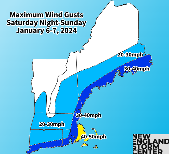
Winds will become gusty near the coast, though not overly strong for most. Gust of at least 25mph will be possible well inland with gusts reaching toward 40-50mph near the coast. The best chance for 50mph gusts will be along the Massachusetts South Shore and Cape Cod. Wind advisories have been posted for the south shore and Cape Cod & the islands.
While these gusts on their own normally wouldn't cause too much of an issue, combine it with wet, sticky snow in the areas expected to see the highest gusts and some power outages could result. This will not be a widespread power outage event.
FLASH FREEZE
The main area where flash freezing could create some problems is across eastern Massachusetts and Rhode Island. These areas will see an abrupt wind shift from easterly to northerly. This will drop temperatures Sunday afternoon, causing rain that has fallen to freeze and allow for snowfall. All of New England will see temperatures drop in the afternoon as the storm pulls away, but northern and western New England will already by around freezing when temperatures drop off.


THE NEXT STORM
Another impactful storm is looking to cross the region late Tuesday into Wednesday. This storm could rapidly intensify as it approaches New England, producing heavy precipitation and potentially strong winds. A surge of moisture-rich, mild southerly air will likely occur as the storm is ongoing. This is seen with potentially widespread 20s and 30s Tuesday night followed by widespread 40s and 50s Wednesday afternoon.With a trend toward a more mild storm, a widespread 1-3 inches of rain will be possible. Combine this with fresh snowmelt and there could be some flooding concerns in southern New England.
Current Weather Prediction Center map for excessive rainfall for this storm:
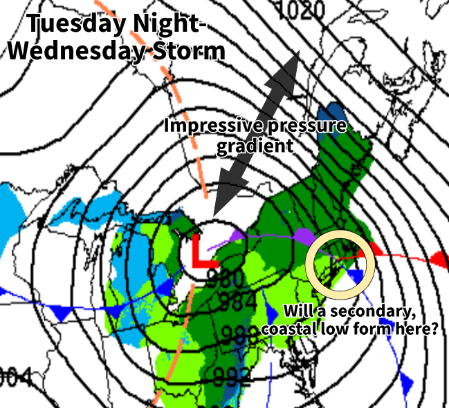
The storm could start as a burst of snow for most before a quick changeover to rain. There is a chance for several inches of snow before the changeover in northern New England and the higher terrain of southern New England. The mountains of northern New England could see decent amount of snow. This would occur as there is plenty of cold air in place initially, but with an expected interior track of the storm, a southerly flow would change snow over to rain for most. If a secondary, coastal low develops, it would lock in the colder air, allowing for more wintry precipitation and cooler temperatures than described above.
With a potent low pressure system to New England's west (possibly around 975-980mb) and a high pressure system to the northeast (around 1,030mb), this will create an impressive gradient over New England. This will support high winds developing over land and sea. There are also factors limiting potential winds, so we'll need to keep watching the trends. The National Weather Service of Boston is already bringing up the possibility of hurricane force wind watches for coastal waters being needed.
This storm will also come with the threat of some coastal flooding. Astronomical high tides will be rising by this point. There's not much guidance available at this point in regards to coastal impacts, but the threat will be there with a potential surge.
Comments