In this week's Weather Wednesday, we go over the latest on this very unsettled stretch of weather as well as look ahead to a potential coastal storm over the weekend.
Prefer to read? There's a written version below the video.
So there is quite a temperature gradient for morning lows this Wednesday morning across New England. A strong area of high pressure and clear skies has kept northern and eastern Maine very cold thanks to prime cooling conditions. Southern New England is being kept warmer thanks to a weak area of low pressure and lots of clouds preventing too much cooling from happening.
At 7am, there was a 43° temperature difference between northern Maine and parts of southern New England. It didn’t get quite as cold as it could have in northern Maine, but a 43° difference is still pretty good. Looking at the unsettled weather for the rest of the week, this afternoon will see very light and scattered precipitation continuing as temperatures continue a very slow climb up as the warm front continues to very slowly wobble through the region.

By Wednesday night, our next system arrives. Temperatures will continue to warm through the night, so Wednesday highs will likely occur at 11:59pm. This storm will likely feature plain rain in southern New England and along the northern New England coast. There will likely be mixing across the rest of New England with freezing rain possible.
Many models show plain rain, but cold air typically takes longer to erode away at the surface than what these models show, so despite the models showing plain rain for most of New England, I think there will still be plenty of mixing and freezing rain overnight tonight to Thursday morning.

By Thursday morning, the air at the surface will likely have warmed enough for plain rain across all but the highest elevations and northern Maine. The snowfall is just about done for today. This afternoon through tomorrow morning will likely see some icing as the warm air continues to erode cold air aloft, but cold air remains at the surface. This is a perfect setup for freezing rain. Fortunately, this is a light precipitation event, so ice accretions will be minimal.
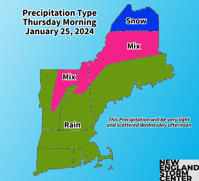
Up to a tenth of an inch is most likely, with some persistent freezing rain in areas maybe pushing up to two tenths of an inch. A glaze will be possible elsewhere. This is enough to cause very slippery surfaces, but not enough to have an impact on trees or utilities. Another storm system, the final one in this particular setup, will come through Thursday night through Friday.

This will be a plain rain system for most of New England. Northern and eastern Maine will see more mixing and snow, leading to a potential for several inches of snow. Elsewhere, a widespread half an inch to an inch of rain will be possible, with Rhode Island seeing maybe up to an inch and a half. A flood watch has been posted for Rhode Island, mainly for the typical problem river the Pawtuxet, which could rise to moderate flood stage.

Probability of seeing at least 2 inches of snow on Friday:

The active January pattern is not leaving after these storms associated with the frontal boundary. On Sunday into Monday, a coastal storm will approach New England. The million dollar question, as it always is at this point, is where will it track?
Models continue to waffle on a closer pass versus a track to the south, keeping a majority of the precipitation away. Should the storm take a favorable track, several inches of snow is possible, with this favorable track, a jackpot zone would most likely set up across northern Massachusetts, southern New Hampshire and southern Vermont. If everything for the storm works out, there could be a chance for over 6 inches of snow. This is very far from being locked in.
What the Euro, GFS, CMC and ICON are currently showing for Sunday afternoon or evening:


There won’t be much cold air ahead of the system, but a cold area of high pressure to the north will likely funnel colder air into New England, possibly as the storm is ongoing. With this setup, it could start as a mix/rain for areas before transiting to all snow.
Depending on timing, it could even be a snowy start, a messy mix in the middle followed by a snowy end. It's really too early to go into too much detail. These are just a couple of the most likely scenarios at the moment. Those scenarios being a messy mix, a snowy end and a mostly miss. We’ll be watching the trends for the rest of the week.
Comments