A blocking pattern will persist over New England for the next few days as a ridge of high pressure over northern New England prevents a coastal system from making a timely exit. This is the same basic pattern we've been in for a while, it's just the high pressure and low pressure systems involved have pushed farther north, allowing southern New England to get in on the cooler, cloudier and more unsettled weather through the weekend.

For Friday, scattered showers will continue across eastern Massachusetts through the day, with the most numerous showers across Cape Cod. Showers will decrease the farther north and west you go. The day will likely end up a lot like Thursday with most missing out on rainfall except for an occasional sprinkle. Northern New England may see a spot "pin-prick" shower or two as a backdoor cold front stalls and eventually washes out over the area due to the stalled system near Cape Cod.

The coastal system will also cause gusty winds and high surf. Winds may gust upwards of 40mph on Cape Cod with occasional gusts to 30mph across all of eastern Massachusetts, Rhode Island and southern New Hampshire. The winds will also whip up the ocean as we approach astronomical high tides. This combination may lead to minor coastal flooding across the New England coast. A coastal flood advisory is in effect for most of the New England coast. Coastal flood warnings are in effect for western Connecticut.

Heading into the start of the weekend, the overall setup will remain largely unchanged with the low pressure system remaining stalled offshore of Cape Cod. The backdoor cold front will likely weaken and fall apart across northern New England as it won't be able to push southward due to the coastal system.
The system will continue to cycle showers into eastern southern New England and southern New Hampshire. Showers may be able to push farther inland than Thursday and Friday, but we'll have to wait and see on that as guidance has had an awful lot of trouble with this one (which isn't a big surprise as these blocking patterns/stalled systems come with the highest uncertainty).
HRRR showing potential weather around midday Saturday:

There will likely be a gradual drying trend from west to east through the day Saturday, with eastern Massachusetts seeing scattered showers for much of the day. The emphasis should be put on scattered, as it is unlikely to be an all day, constant rain, just more of the same.
The coastal system will begin to be pushed south and east out to sea later Saturday as high pressure over eastern Canada nudges back down into New England. This will bring dry weather back for all of New England to start next week. Sunday may see lingering showers across southeast Massachusetts, but other than that, the system will be pulling away.

A consistent onshore flow will keep very fall-like air around for much of New England with a cool breeze, cool temperatures and some cloud development. It will be a notch warmer across western Massachusetts and Vermont (away from the mountains) through early next week well away from the coastal influence (think low 70s instead of low to mid 60s farther east).
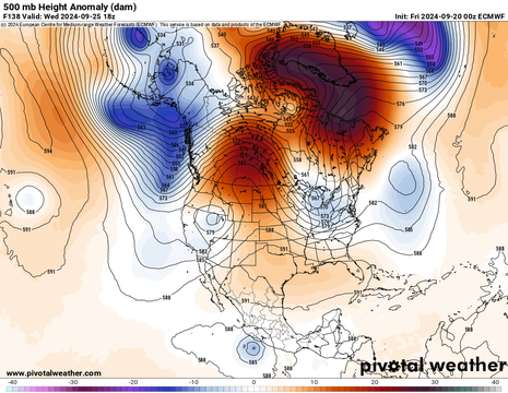
New England's next chance at precipitation will come around mid to late next week as a trough traverses the northern tier of the country. There is much uncertainty in what will happen with this system as large-scale blocking over eastern Canada may delay or alter its arrival in the northeast. Depending on how things shake out, this could be the beginning of the breakdown of this large block and allow more chances for wet weather across northern New England. At this point with the uncertainty, it's a wait and see scenario for now.
1st image below: Weather map for Wednesday morning (September 25). 2nd image below: 500mb height anomaly on Wednesday showing the large-scale blocking ridge over eastern Canada. This may begin to break down as this system approaches:


Comments