New England is entering a hyper active weather pattern, with multiple storm chances over the next two weeks. Right now, the most impactful storm is looking to strike this weekend. Being late-March, this storm is looking to be a high elevation snow event with a cold rain and mix in lower elevations.
This storm is looking to follow a trend that many storms have followed this winter. That trend being that a primary low will track to our north with a secondary low forming along New England's south coast. The primary low to the north decays and transfers energy to the strengthening secondary low to the south. The secondary low then becomes the primary low.
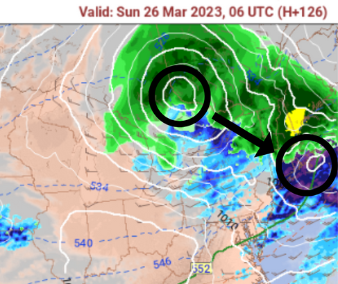
Here's a graphic showing the setup followed by the setup on a real world weather model for this upcoming storm:


Models have been trending toward a colder storm, which makes sense given the setup described above. Colder air can get locked into New England between the two low pressure systems, leading to spring snow. The bulk of precipitation is looking to fall overnight Saturday into Sunday. That helps accumulate snow as the strong sun angle will not be a factor in dampening snowfall.
This will very likely be a quintessential springtime storm, with high elevations seeing the most snow while lower elevations see a cold rain. Exactly how much snow falls remains the big question that still needs to be answered.
As of right now, it looks like winter storm warning level snow could fall across the White Mountains, New Hampshire foothills, Maine mountains and downeast Maine. This is still rather uncertain as models are indicating a 50/50 chance of at least 6 inches in these areas. These chances, despite being at a coin toss point, have increased over the past couple days.

Less snowfall will be possible in the higher elevations of southern New England. The Berkshires and Worcester Hills are looking at the possibility of rain mixing with some snow and sleet, but accumulations are looking less likely than yesterday. These areas may start and end as snow.
Lower elevations of southern New England will likely see a mainly cold rain. Many areas will likely see some snow mix in Saturday evening, but accumulations will be hard to come by in these areas. Lower elevations of northern New England could see some snow, with a couple to a few inches possible in interior areas.
The jackpot zone will likely be the White Mountains into central Maine.
The key to nailing down snowfall amounts will be getting a better idea of the track of the coastal low, as well as how much strengthening it can undergo in the Gulf of Maine. A track further north would result in warmer air working in and lower snowfall while a track further south would pull colder air down from the higher elevations. Naturally, the stronger the low gets, the more precipitation the storm will produce.
This storm is looking to enter the region Saturday afternoon with the bulk of the storm coming through Saturday night. The storm will likely begin shutting down for much of New England Sunday morning. Maine will be in the storm through much of the day Sunday. The storm will exit New England by Sunday evening.
As stated before, this will come in the midst of an active weather pattern for New England, with precipitation chances coming every 24-36 hours for the foreseeable future. Welcome to April showers.
Stay with New England Storm Center as this storm continues to come into focus.
Comentarios