Spring Nor'Easter Hangs in the Gulf of Maine as Cleanup Continues
- Tim Dennis
- Apr 5, 2024
- 3 min read
New England's spring nor'easter has cutoff and will hang in the Gulf of Maine through Saturday, weakening as it does so. The presence of the low will result in wrap around snow and rain showers continuing through tonight and into Saturday for eastern Maine. These showers will generally be light and any additional accumulations will be on the lighter side.
Expected weather Friday afternoon (1st image) and Saturday morning (2nd image):


This nor'easter was the latest in what has ended up being a very snowy spring for New England. This was the second storm to drop at least two feet of snow on New England this season and the third to drop at least one foot. All of this has come as we're only 17 days into the new season (though we should be calming down with the snow now).
In our forecasts for this storm, we talked a lot about a potentially sharp cutoff in snowfall. This did end up happening with around 20 inches reported in Shapleigh, Maine and just 6 inches reported in Kennebunk by Thursday afternoon. These towns are about 20 miles apart. Kennebunk is a coastal community, which did help keep their numbers down.

Much of this snow came down as the wet and heavy kind, leading to another major power outage event for New England. Cumberland and York counties in Maine were hit the hardest with outages, which were the two counties that were hit hard by a recent ice storm. As of 9am Friday, both of these counties were experiencing nearly 80,000 outages each.
Total outages in New England have dropped to just under 389,000 as of 9am. This includes over a quarter million in Maine and over 100,000 in New Hampshire. Major utility providers in both states (Central Maine Power, Versant, Eversource and Unitil). Central Maine Power has stated that full restoration may take up to five days. Vermont's primary provider, Green Mountain Power, also stated that restoration will likely continue through the weekend.

This comes as the combination of heavy, wet snow and widespread wind gusts of 50-70+mph were seen across New England. This led to significant tree and power line damage. This includes an entire row of toppled utility poles in Weare, NH across Route 114 and a utility that smashed down onto a plow truck in Maine. Eversource alone has reported over 200 road blocks and nearly 100 broken utility poles.
The scenes described above:


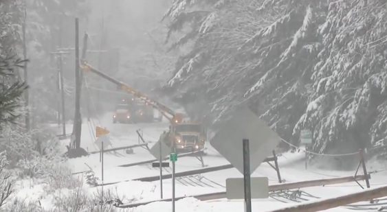
Photo credits: Central Maine Power, Unitil
On top of this, heavy rain fell in southern New England, prompting rivers to once again rise this spring. The Sudbury, Pawtuxet, Pawcatuck, Taunton, Wood and Charles Rivers in Massachusetts, Rhode Island and Connecticut are currently under flood warnings. Minor flooding is forecast or occurring at each of these rivers.
River at flood stage in New England:

With this storm winding down, attention turns toward Monday. New England has had some of the best prospects in the country this week for eclipse viewing. This is still holding as mostly sunny to partly cloudy skies are looking likely.
A backdoor cold front will need to be watched, but the arrival of this front has been trending toward later Monday and into Monday night. We'll also need to watch for some clouds to enter western Vermont Monday afternoon from a system to the west. Even with both of these features, viewing conditions are still looking good. We'll have a much more detailed eclipse article tomorrow.
Canadian ensemble showing the chances of 25% or less cloud cover Monday afternoon:

Commentaires