Spring Nor'Easter Brings New England More Heavy Snow, Power Outages
- Tim Dennis
- Apr 4, 2024
- 2 min read

The snow keeps piling up this spring after failing to do so for much of the winter. This early- April nor'easter has become the second storm this spring to put up at least two feet of snow and the third to put up at least one foot of snow. In a bit of a surprise, Vermont has generally led the way in snow totals thus far. Snow will continue to fall throughout the night across much of northern New England, so the totals below are certainly not final.

Being April, this was generally a wet, heavy snow. This has, expectantly, caused a major power disruption across the region. As of 9pm, nearly 450,000 customers across New England are without power 300,000 of these outages occurred in Maine. Cumberland and York counties both saw well over 80,000 outages. Both of these counties were hit hard by the ice storm during the last system in late March.

This will be a days-long power outage for some in Maine and New Hampshire. Maine's Central Maine Power and Versant Power and New Hampshire's Unitil and Eversource have confirmed a multi-day restoration will take place.
Scenes of power line and tree damage from Maine and New Hampshire:


Photo credits: Central Maine Power, Wicasset Police Department, Colbie Holloway, WMUR, Unitil
Along with the heavy snow, high winds exacerbated problems. Many reports of wind gusts from 50-70mph were reported across New England, with the highest reported gust at 73mph in Welfleet, Massachusetts.
On top of this, minor to moderate coastal flooding was seen, primarily across Massachusetts and New Hampshire. Numerous coastal streets across these states were inundated and closed around the Thursday morning high tide.
Coastal flooding in Massachusetts:


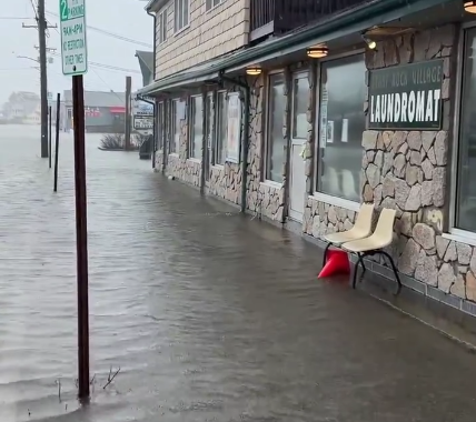

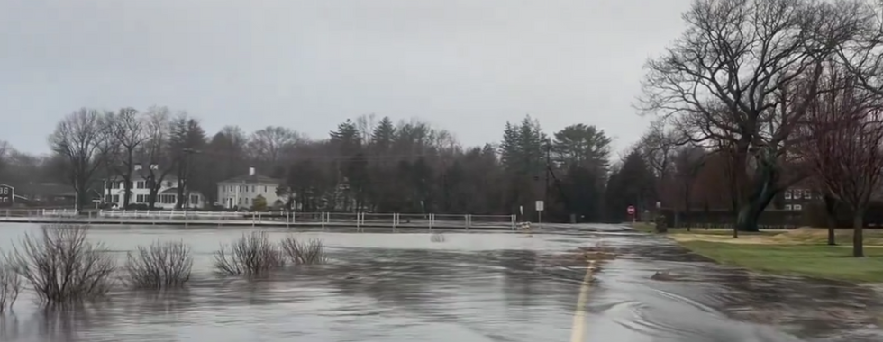
Photo credits: Carlos Munoz, Chris Gloninger
This storm has stalled out in the Gulf of Maine. The storm will continue to cycle snow and rain showers into New England on Friday and into Saturday in some places. The system will be weakening as it lingers over the next couple days, so the heavy snowfall rates and gusty winds will be diminishing during this time, but additional accumulations remain likely.
Expected weather Friday morning:

The storm continues to look like it will clear out just in time for the eclipse. At this point, viewing conditions are looking favorable across the region. We do need to continue to watch a backdoor cold front that is expected to dive into New England sometime Monday or Tuesday, but this front will be a dry passage.
Canadian ensemble showing the chances of 25% or less cloud cover Monday afternoon:

コメント