Significant Flooding Has Occurred in Southwest Connecticut
- Tim Dennis
- Aug 18, 2024
- 3 min read
Updated: Aug 19, 2024
A nearly stationary band of very heavy rainfall set up across southwest Connecticut Sunday afternoon, leading to extreme rainfall. Estimated totals are currently showing 6-10+ inches of rain having fallen across a narrow section of Connecticut. This came as a frontal system has been very slowly moving eastward over the past couple days due to offshore high pressure and the distant Hurricane Ernesto.
Observed 24 hour rainfall:

The communities of Southbury and Danbury were hit particularly hard. Fairfield and New Haven counties were put under a flash floods emergency for Sunday afternoon. This rare alert is issued only for flooding events that have turned truly dire and very dangerous. Over a dozen roads in Southbury have been washed out and closed, including all lanes of Route 172. The town is under a state of emergency and is covered in a thick layer of mud.
Multiple scenes of vehicles underwater in roadways from the community have emerged. Up to 40 campers in Southbury are trapped after road and walking bridges in Kettletown State Park were washed out. In Shelton, multiple docks and boats were pulled off the shore line of Lake Housatonic and floated downriver. The Housatonic River has reached major flood stage and is still rising. Four buildings along the Naugatuck River have been compromised and are being evacuated.
In Danbury, a mudslide has been reported to have caused a major gas leak early in the afternoon. A building was evacuated, but the gas leak situation has been reported to be "isolated and under control." Other buildings in Danbury were evacuated due to flooding. Woodbury, Connecticut has also reported numerous roads around the town as underwater and impassible.
Scenes of flooding around southwest Connecticut:


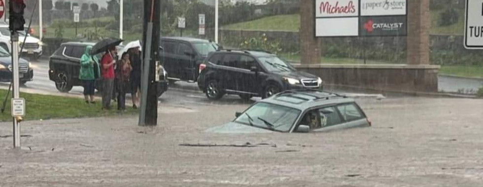


Photo credits: Matt Austin; Zander Sahilia; Jack Drake; NBC Connecticut; Connor Dinallo; Maybe: K*RK
In Monroe, Connecticut, multiple motorists have been reported to be stranded in flood waters. Earlier in the day, water rescues occurred across Sanford, Connecticut, mainly in the late morning. Substantial river flooding has been reported in nearby New Canaan.
In Oxford, residents inside a home as well as patrons at a nearby restaurant were reported to be in need of rescue. The Air National Guard arrived to assist with rescues. At least two people were swept away by the flooding Little River in Oxford. Tragically, both have been confirmed to have died.

The main flood threat for Sunday was expected to be farther west. A flood watch was posted for portions of New Jersey, New York and Pennsylvania. Far western Connecticut was included in the "slight" (level 2 of 4) chance for excessive rainfall this morning. Late Sunday afternoon, the flood watch was expanded to include southwest Connecticut.
High resolution guidance generally depicted 1-2 inches of rainfall occurring to the west of New England today, which prompted the above flood watch. The slow-moving nature of the system interacting with a moisture-rich atmosphere led to these very high rain totals. This band of extreme rain farther east was missed by guidance.
This event is starkly reminiscent of the surprise major flooding event that took place in the Northeast Kingdom of Vermont on July 30th. That night, a cutoff low pressure system dropped 4-8 inches of rain in a narrow area of northeast Vermont after rapidly strengthening. Today, a very slow moving frontal system led to a stationary band of thunderstorms setting up over southwest Connecticut.
NAM rainfall prediction from yesterday evening:

Comments