Scattered Showers, Strong Wind Gusts Follow Storm for New England
- Tim Dennis
- Mar 6
- 3 min read

The storm's primary cold front will continue to race eastward, pushing through Maine by early this afternoon. This passage marks the end of the steady rainfall and downpours. A secondary cold front will swing across the region late this morning through the afternoon. This may re-ignite some scattered showers through the afternoon and evening hours, as well as bring an end to these mild temperatures.
Below: HRRR showing potential weather around mid-afternoon today:
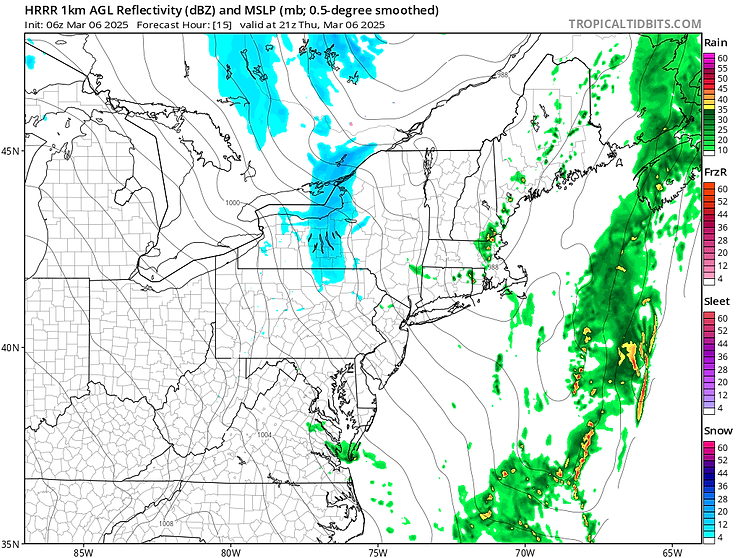
As the storm's primary low continues to lift north and east of New England, a secondary low along the storm's cold front will develop and strengthen as it moves into eastern Maine. This will allow precipitation to blossom over the state heading into the evening and overnight hours. Residual moisture may allow for continued scattered shower (rain and snow) activity across the higher terrain through the night as well. With plummeting temperatures and more numerous showers tonight, Maine may see a flash freeze.

Scattered rain and snow showers over Maine will likely begin to become more numerous once again heading into this evening and the start of the overnight hours. With rapidly cooling temperatures, the rain showers should steadily transition to snow showers through the overnight hours. Snow showers will continue across eastern Maine into Friday morning before gradually winding down as the low pressure systems continue to move north and east.
Below: HRRR showing potential weather from this evening through Friday morning:

Heading into Friday the main story will be in the increasing wind gusts. A low-level jet (located about 4,700 feet above sea level) of 55-70mph will be in place over New England Friday morning into the afternoon. With a tightening pressure gradient as the storm system departs, cold air advection occurring and clearing skies all aiding in mixing, stronger gusts will have a much easier time mixing to the surface than they did Wednesday night.
The higher elevations of southern New England (Berkshires, Worcester Hills) are currently in line with the strongest of the low-level winds to see the strongest gusts during the day. Gusts here could reach over 50mph at times with an outside chance of reaching 60mph. Elsewhere in New England, gusts over 40mph will be possible throughout the day. A secondary area of very high winds is naturally expected across the White Mountains as well. High wind warnings have been issued for the Worcester Hills and downslope Berkshires.

Heading into the weekend and next week, the overall flow pattern will begin to trend more zonal. This will generally keep southern stream storm systems to the south of New England. A series of northern stream disturbances look to trickle through New England with minimal impacts. Without the help of southern stream systems, the northern streamers will result in not much more than some clouds at times and maybe a few light rain/snow showers. The weekend is looking mainly to completely dry for much of New England with cooler temperatures.
Below: Synoptic daily weather maps for Friday (3/7) through Wednesday (3/12), showing a series of fronts and disturbances, but little by way of precipitation:

The most "widespread" precipitation-maker in the near term will likely slide through New England on Monday. This is still just a northern streamer that may produce some light snow or rain showers as it skirts through the region. Widespread is in quotes as moisture will be lacking and the disturbance will likely have trouble spitting much rain or snow out. There are no organized, large-scale storm systems on tap for New England over the next week.
A sub-tropical ridge of high pressure is expected to slide across the southern United States moving into next week. This will allow for a gradual increase in temperatures after the weekend cool-down. Temperatures will likely be back above average by mid-week next week. Depending on exactly how everything sets up, low 60s will be possible in southern New England by next Wednesday.
With the ridge crossing the southern United States, areas south of New England have higher confidence in warm temperatures. This also results in confidence in higher temperatures dropping off moving northward in New England, as seen in the Climate Prediction Center's current 6-10 day outlook. The next organized storm may enter the picture late next week.

Comments