After tracking this storm for over a week now, we're into the final countdown. As of Monday morning, the storm is just starting to get its act together. The two pieces of the storm will be coming together as today goes on.
This radar image as of 8am Monday shows the two main energy sources that will be coming together to form our powerhouse nor'easter. Light rain and snow showers will occur today as things become more organised. The storm will ramp up quickly tonight.

ALERTS

SNOW
Snowfall rates of 1-3 inches an hour is possible in areas of western New England during the height of the storm. There will be two main bands of heavy snow, exactly where these bands end up will be hammered.
It looks like the highest snow totals will occur in the Berkshires, Litchfield Hills, southern Green Mountains, Monadnocks and New Hampshire's Merrimack Valley. Notice that all but one of these regions are mountains and hills.
Our snowfall forecast has not changed since yesterday evening's update:

While very heavy snowfall is likely, there are several factors that are working against very large snow totals. For one, this will be a heavy, wet snow, which compresses. This makes it difficult for snow to pile up. Another issue is that there's absolutely no cold air ahead of the storm. While the storm will be able to create its own cold air, there will be nearly no cold air damming in New England. The strong mid March sun angle will melt some snow as it falls.
Eastern Massachusetts, Rhode Island and the seacoast region of New Hampshire will see some snow, but likely not to the extent of the jackpot areas. The storm will mix with rain, and will start as all rain Monday night. Much of these areas will switch over to a mostly snow or snow event by Tuesday afternoon to evening. Several inches of snow is expected in Boston and much of eastern Massachusetts and southern New Hampshire will likely see 6-12 inches. The most intense snow will likely come Tuesday afternoon through Tuesday night for these areas.


There could be an extremely sharp cutoff in snow totals. You may not have to travel very far to go from not much snow to a lot of snow, especially in central Massachusetts, southeast New Hampshire and southern Connecticut.
Northern Vermont, northern New Hampshire and much of Maine will likely see a decent thump of snow, but not to the extent of the jackpot areas listed above. This is due to the fact that you are getting further away from the center of the storm, so these areas will not get into the heaviest bands of snow.
WIND
Regardless of the precipitation type, there will very likely be strong winds. As the storm strengthens rapidly, the winds will ramp up big time. Much of eastern and coastal New England could see very strong winds. The entire New England coast could see gusts upwards of 50-55mph possible. Cape Cod and the islands could see gusts upwards of 60-65mph. High wind warnings have been posted for the Massachusetts coast.
While the wind strength will be focused on Cape Cod and the south shore, gusty winds will be seen across most of New England. The combination of gusty winds and heavy, wet snow on tree branches could lead to problems in the snowfall jackpot areas.
COASTAL FLOODING
The coastal flooding threat has INCREASED since yesterday. Coastal flood watches have been posted for the entire Massachusetts coastline. While minor coastal flooding is still expected to be dominant, there could be pockets of moderate flooding. The watch states:
"Large waves may produce pockets of moderate flooding along the ocean shoreline in places such as Gloucester, Revere, Hull, and Scituate. Flooding could be 1 to 2 feet deep in some locations and debris could wash onto coastal roadways. Significant beach erosion is also possible."
The main time to watch for flooding will be Tuesday night and Wednesday.
POWER OUTAGES
There will be power problems from this storm. It looks like there will be two pockets of widespread outages in New England. There could be one area along the south shore and Cape Cod due to damaging winds. The other pocket will likely be central and western Massachusetts into southwest and central New Hampshire due to heavy, wet snow weighing the branches down. There will be tree damage from both wind and heavy snow.

TIMING
Monday: Clouds build in the afternoon, precipitation begins in southern areas in the mid to late afternoon. There will be scattered light showers throughout the day.
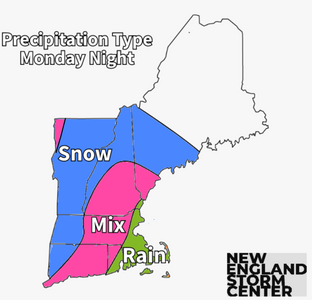
Monday night: Snow falling in the interior and higher elevations. Rain/mix in eastern and coastal areas.
Tuesday morning: Still snowing in the interior, rain/snow mix line will begin to gradually drop southward.
Tuesday afternoon: Rain/snow line drops to near Boston, rain/mix at immediate coast.
Tuesday night: Snow for most of New England, the heaviest snow is over. Rain/mix on Cape Cod.
Wednesday morning: Lighter snow continues. Maine sees steadier snow, mixing at coast.
Wednesday afternoon: Storm very slowly pulls away, snow showers continue.
Wednesday night: Drying out across much of New England, snow showers continue in Maine.
Thursday morning: Storm gone.
Stay with New England Storm Center as this potent nor'easter develops.
Kommentare