UPDATED 10:30am Sunday. All maps have been updated with only minor edits to text this morning.
A potent storm system will be coming to New England Sunday night into Monday morning. This storm will be a multi-hazard one, with heavy rain, strong winds and snow across the higher terrain of northern New England.

An area of low pressure will track to New England's north Sunday into Sunday night. As it does so, it will drag a strong cold front across the region. A secondary low will form along the front and strengthen as it moves through New England.

ALERTS

TIMING
Initial showers will likely break out across Vermont and western Massachusetts by Sunday late-morning to midday, mainly in western New England. Scattered showers will slide further east through the afternoon, however, a steady rain will not be happening yet. The first half of Sunday is still looking to be dry across most of New England.
Expected weather Sunday early afternoon:

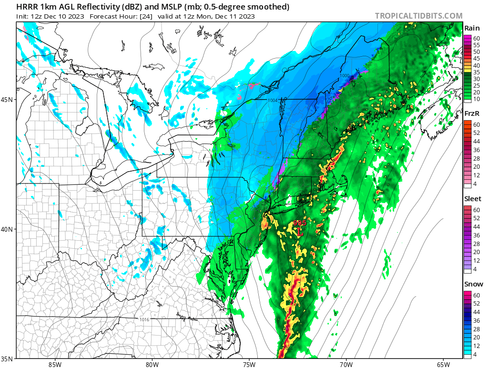
By Sunday evening, rain showers will likely have overspread the entirety of New England. The band of heavy rain will likely begin setting up at this time. Winds will also begin to gradually increase at this time, though they will not be anything of note quite yet. The rain and wind will continue to pick up in intensity as Sunday night goes on. The storm will likely peak early Monday morning for much of New England. Late Sunday is also when rain will likely begin changing to snow at elevation in the Green Mountains.
Potential weather Sunday evening (1st image) and overnight (2nd image). Note the switchover to snow:


By around sunrise Monday, rain and snow will continue falling across New England, but the system will begin to slide eastward as the cold front begins sliding through New England. The shield of heavy rain will likely begin to race eastward shortly after sunrise. A quick drying trend will take over from west to east Monday afternoon.
Expected weather Monday around sunrise (1st image) and early Monday afternoon (2nd image):


RAIN
This storm will likely feature a shield of heavy rain moving across New England overnight Sunday to Monday. Rainfall amounts have continued to trend up. A widespread 1-3 inches of rain will be possible across all of New England, with locally amounts up to 4 inches not out of the question, mainly across Connecticut and southern Maine.

Rainfall has continued to trend upward, leading to an increased concern in flooding potential. A handful of rivers across New England are forecast to reach minor flood stage at this time.
Poor drainage flooding will likely be the most common flood issue with this storm. Rainfall rates will have the chance to be heavier than they typically get this time of year. Across parts northern New England, snowmelt will also contribute to rivers and streams filling up along with the rainfall.
Flash flooding isn't a major concern, but it is still possible with the rainfall rates that could be achieved overnight. The Weather Prediction Center upgraded a portion of New England to the second level of flash flood potential. Areas in New England where the ground is frozen will have a harder time getting rid of the water.

WIND
The one piece of this storm that has been well known for a little while is the chance for strong winds. We've been talking about the strong winds aloft, which will be in the 80-90mph range. The strongest core of this wind will be centered just offshore. Through Saturday, the core of strongest winds have trended further east, so the strongest winds have trended further east.
Here's what we're talking about when we say winds aloft. This is the winds at 925mb (or about 2,500 feet above sea level) overnight Sunday. The core of this wind becomes stronger Monday morning, but also shifts offshore:

Not all of the wind aloft will make it to the ground, but winds this strong aloft would support gusts of 50-60+mph. There may also be what's called an inversion, or cap, above the surface level, which would help keep the strongest winds aloft. So, there are factors as to why winds will be very strong, and other factors that could help limit winds.
With all of that said, coastal areas of New England are still looking at gusts of 50-60mph along Cape Cod and the immediate coast. Downeast Maine will likely see the highest gusts, where 60-70mph will be possible. Gusts of 30+mph will likely be felt across most of New England. This will be enough to cause some power outages, though widespread outages across eastern New England from windis unlikely. The trees can take on stronger winds without leaves.

Winds will become gusty Monday afternoon behind the front, but these winds are very unlikely to become impactful. Portions of western New England will likely see their strongest wind gusts (30-35mph) Monday afternoon.
SNOW
With an eastward trend in the system, snow chances have expanded across Vermont, into New Hampshire and the Berkshires. This is now looking like a snowstorm across Vermont rather than a flooding rain event. Snow will still be highly elevation dependent.

With the increase in snowfall, the threat has increased quite a bit for power outages across Vermont due to heavy, wet snow weighing down branches and power lines. This, combined with gusts of 30-35mph, will likely lead to power problems, espeically across northern Vermont and into northern New Hampshire.
POWER OUTAGES

COASTAL FLOODING
Coastal flooding is not too much of a concern with this storm thanks to wind direction and relatively low astrominical tides. The greatest area of concern is Rhode Island's Narragansett Bay. This area could see minor to potentially moderate coastal flooding. Some splashover will be possible across much of New England's coast.
Despite an onshore flow into Maine, astronomically lower tides combined with the fact that max surge will arrive a few hours after high tide will significantly cut down coastal concerns there.
Comments