NO REST: Alerts Issued Ahead of New England's Next Storm: Impacts, Timing
- Tim Dennis
- Jan 8, 2024
- 4 min read
Updated: Jan 8, 2024
New England's next storm is already on its way after this weekend's snowstorm. This storm is currently working through the middle of the country and will arrive in the northeast by Tuesday afternoon. This storm, unlike the weekend storm, will be a multi-hazard event with rain, snow, wind and potentially some coastal flooding. Also unlike the weekend storm, this will be a quick-hitter.
The storm will initally start with a burst of snow or a wintry mix, however, a surge of mild air from the south will work through New England, gradually changing the wintry mix to plain rain from south to north. Naturally, the further north (and east) you are in New England, the longer the storm will be snow, leading to more accumulation. For southern and central areas, heavy rain combined with fresh snow melt will lead to flooding concerns.

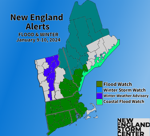
ALERTS


TIMING
Precipitation will enter into southwest Connecticut Tuesday afternoon and spread northeast throughout Tuesday evening. As stated in the introduction, most areas will see a quick bust of snow before a changeover to rain as the mild air surges northward. Some accumulations will be possible in southern New England, mainly in the higher terrain. This will be washed away.
Expected weather Tuesday evening:

By the early morning hours of Tuesday, all of southern New England should be seeing plain rain. Southern New Hampshire and Vermont will also likely have made the transition at this time. Further north, heavy snow will likely still be ongoing. The snowfall will also make its way into northern and eastern Maine at this time.
When we said this would be a quick-hitter, we meant it. Southern New England will begin winding the storm down by sunrise Wednesday. Vermont and New Hampshire won't be long after that. Maine, being the furthest east, will naturally remain in the storm longer than the rest, though it will start later. Despite the quick wind down, winds will remain gusty after the storm exits.
Expected weather overnight Tuesday to Wednesday (1st image) and Wednesday around sunrise (2nd image):


By Wednesday evening, scattered showers will likely be persisting, mainly across northern New England as the region will remain under cyclonic flow. The main storm system will have exited well to New England's north. Some clearing may be able to happen Wednesday afternoon across southern New England.
Expected weather Wednesday evening:

RAIN
The biggest concern with this storm system will be the pounding rain combined with recent snowmelt. The further south in New England you are, the higher the concern for potential flooding issues as more rain is expected. Further north, this will be more of a wintry event. The atmosphere will be extremely moisture rich. Precipitable water values (or PWAT values, which you can read about in this forecast post from the summer) may near record levels for the time of year. This will allow for potentially very heavy rainfall rates.
The one piece of the storm that will help New England is the fact that the storm is moving very quickly, so while the rainfall will be very heavy, it won't last for hours and hours on end. When the storm finishes, a widespread 1-2 inches of rain will likely have fallen across southern and central New England with some amounts nearing 3 inches in Connecticut. Lesser rain will be seen north thanks to more snowfall.

With heavy rainfall rates comes the possibility of flash flooding and street flooding. This much rain will also combine with snowmelt after as much as a foot and half fell in parts of New England. Continued snowmelt through Wednesday will also likely lead to some river flooding.

Across northern New England, especially into the mountains, the main question will be just how long it takes for the heavy snowfall from this storm to change over to rain. The snow that was received this past weekend was of the very dry variety, which will help limit or control flooding in northern New England.
SNOW
As stated in the introduction, the storm will begin as a burst of snow before changing over to rain from south to north. Generally, the further north and higher in elevation you are, the longer the change over will take, leading to more snow. Areas that stay snow for most of Tuesday night will likely see upwards of 10"+ inches of snow.
The big question for northern areas is just how long it takes for the switchover to rain to occur. Pretty much everything that falls in southern and central New England will be quickly washed away by the torrential rain. Confidence is rather high that this switch will happen quickly. Still, some winter weather advisories could be posted in southern New England in the higher elevation areas.

WIND
Another big issue with this storm will be high, possibly damaging winds. There will likely be two areas in New England that see the strongest winds: the higher elevations of western New England (Green mountains and Berkshires) and along the coast. At the coast, a strong low-level jet will have the chance to create gusts of 60-70mph, with the strongest across downeast Maine. The big question, as always, with this setup will be just how much of that strong wind aloft can make it to the ground.
Into western New England, a strong pressure gradient between the area of low pressure to the west and an area of high pressure to the east will be enough to create winds of up to 50mph in these areas. The storm will have the potential to create a downslope wind event. This could boost wind gusts in the western Green Mountains to the 60-65mph range.

Power outages will be a concern across coastal areas of New England and across portions of Vermont and New Hampshire where a downslope wind event is expected. These areas will also see a wet, heavy snow, which will put a further strain on trees. Confidence in high winds is actually higher across the Green Mountains than it is along the coast.
Parts of New England outside of these two areas detailed above will not see as much wind as the location of the strong low-level jet does not favor stronger winds reaching the surface away from the coast.
COASTAL FLOODING
There is a chance for coastal flooding with a southeast flow causing a surge of 2-3.5 feet. The big question is if this surge will be timed with high tide. The tide cycle affected would be the Wednesday morning high tide. There is high uncertainty on the extent of coastal flooding. This threat should become more clear by in the next 12 hours.
Comments