New England Weather This Week: Warming (Eventually)
- Tim Dennis
- Jun 10, 2024
- 3 min read

The week starts with more of the same, but changes come later in the week. A warming trend will also take shape as the week progresses, until a cold front crosses the region late in the week.
MONDAY-WEDNESDAY
The week will begin with the rather stagnant weather setup that has been over New England for the past several days. A large, upper-level low will continue to sit to the north of New England. This low will slowly be drifting away over the course of the next couple days. Monday and Tuesday will basically be carbon copies of each other with partly cloudy skies and isolated showers popping up in the afternoon.
The farther north in New England you go, the more numerous the clouds and showers will be. Northern Maine will likely see rain for much of the day on Monday and the most numerous showers on Tuesday afternoon as the area is closest to the center of low itself.
HRRR showing potential weather on Monday afternoon (1st image) and Tuesday afternoon (2nd image):


Wednesday will continue the overall drying trend as the upper-level low departs and high pressure builds to New England's west. Still, colder air aloft will remain over New England. This will support some cloud development in the afternoon and isolated showers chances once again, though coverage should be very limited.
With the colder air aloft and general troughing continuing in the first half of the week, temperatures will remain a bit lower, though most areas will remain right around seasonable levels, with the 70s dominating. The northern tier of New England will likely be held to the 60s on Monday thanks to more clouds and showers. Wednesday will begin a warming trend for New England with some parts of Southern New England returning to the low 80s.

THURSDAY & FRIDAY
Thursday will continue the warm-up that began on Wednesday. This will come as a deep southwest flow develops ahead of an approaching system. Both Thursday and Friday look to feature widespread 80s, though areas north and west in New England may be held to the 70s on Friday.
A system will pass to the north of New England on Friday, which will drag a cold front across New England, bringing the chance for showers and storms as well as slightly cooler temperatures for Friday and into the weekend. How warm it gets on Friday will be determined by the frontal passage timing.
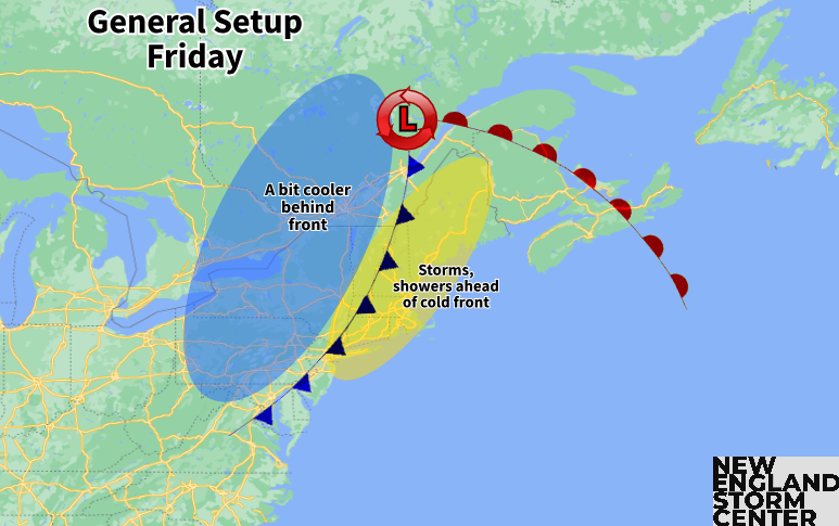
Thursday does look to be dry with variable clouds. Friday will need to be watched as the cold front timing will determine the timing and extent of thunderstorms. As per usual, the area of New England that sees the frontal passage in the afternoon will have the best chance for more widespread thunderstorms. Depending on the exact timing of the front, a portion of New England could have the chance to see severe storms as the four main ingredients will likely be in place.
WEEKEND
As of now, the upcoming weekend is looking very nice. Once the cold front clears the region, clearing will take place. The cold front will help drop temperatures a notch, likely back into the 70s to low 80s for both Saturday and Sunday along with low humidity.
At this time range, this is not quite locked in yet as a later trend in the cold front could lead to a more unsettled start to Saturday. As of now, it does look like the parent low will move out of the area by Saturday, but if it decides to linger, it could also lead to a downward trend in at least Saturday's forecast. Overall, odds favor a very nice and comfortable Father's Weekend.
Weather map for Saturday showing the cold front having cleared the region with high pressure building back to the west:

BEYOND
Looking into the long term, warmth may surge back into New England early next week as a trough-in-the-west-ridge-in-the-east pattern shows signs of developing. This is supported by the Climate Prediction Center's 8-14 day outlook, which currently covers June 17-25.


コメント