This week will feature a continuation of weaker northern stream systems parading through New England. These will bring a couple more chances for minor snowfall along with another (brief) shot of cold air. This weekend is being monitored for continued active weather as well.
MONDAY
Today will be the quietest day of the week for New England. The biggest weather feature will be gusty winds as an intensifying low pressure system well to New England's north creates a tight pressure gradient. Wind gusts this afternoon will range from 25-40mph, with the strongest gusts across the northern third of the region, closer to the low pressure.

Other than the gusts, the day will feature variable clouds, becoming overcast in the afternoon across the northern tier as a strong cold front approaches. Southern New England will likely see a mainly sunny day. Temperatures will remain close to seasonable levels across the region.
TUESDAY
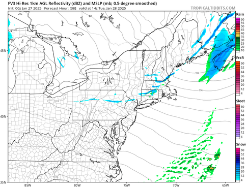
Late Monday night through Tuesday morning, a strong, Arctic cold front will plow through New England. This front is associated with the strong system moving well north of New England. This cold front will support a line of snow showers and scattered squalls moving from northwest to southeast through New England from the pre-dawn hours across northern Vermont and Maine to about midday for southeast New England.
A fine line of squalls may develop for the northern third of the region before sunrise Tuesday. The line will likely begin to break up and weaken as it pushes southward through New England, but scattered snow showers and potentially squalls will be possible across the region. More areas in southern New England will likely miss a snow shower than get one.
Below: NAM and FV3 showing potential weather in the pre-dawn hours Tuesday:


As far as squalls go, a narrow band of frontogenesis is expected along with steep lapse rates for Tuesday morning. While instability will be limited with a morning frontal passage, a spike in moisture and convergence along the front will support isolated to scattered squalls. With that said, snow squall parameter values range from 1-3 across New England, indicating a favorable environment for development.
Areas that do get under a snow squall or see more persistent snow showers will likely pick up a quick inch of snow Tuesday morning. The higher chances for snow squalls across the northern tier of New England can be seen in the probabilities for an inch of snow. Probabilities are 40-70% across the northern tier through Tuesday evening.
Below: Probability of at least an inch of snow through Tuesday:

Once the front passes by the early afternoon, temperatures will drop quickly and the wind will pick up. Highs will likely be reached in the morning for most of New England with falling temperatures through the afternoon. Temperatures will likely tumble 10-15° through the daytime hours.
WEDNESDAY
A weak clipper system will slide through the region Tuesday night into Wednesday. The track of this system is looking to be right through New England and into the Gulf of Maine. A weak, secondary low may develop off the coast. This will support a period of widespread light snow across the region.

The most widespread snow appears to move from west to east through Wednesday morning, though the secondary low would help snow showers last longer into Wednesday, should it be able to develop. The general idea will be for snow to break out Tuesday night and slide west to east through the morning Wednesday. By Wednesday afternoon, much of the snow will likely be confined to the higher elevations and Maine. Elsewhere, snow will likely gradually break up.
Below: NAM showing potential weather around sunrise Wednesday (1st image) and early Wednesday afternoon (2nd image):


This will be a weak system with light accumulations. A widespread dusting to two inches of snow will be likely across much of New England with a jackpot zone across the central Green Mountains, where 2-4 inches will be possible. Southernmost and northernmost New England will likely see the least. Some mixing and rainfall may occur across southernmost New England should precipitation linger into Wednesday afternoon.
Probability of at least 2 inches of snow from Tuesday night to Wednesday night:

THURSDAY
The departing clipper will open the door for a blast of Arctic air, as they often do. Thursday will be very cold and windy. Highs will likely range from the teens north to mid 20s south with lows in the single digits to mid-teens. 20-30mph wind gusts will knock the feels-like temperatures into the single digits and teens south to the -20s north on Thursday.

FRIDAY
This Arctic blast is looking increasingly short-lived. By Friday morning, a weak disturbance looks to slide to the north of New England, lifting a warm front into the region and allowing a milder flow and air mass into the region. Highs for Friday have trended up quite a bit over the past 36 hours or so, with many areas nearing, or jumping above, the freezing mark. As for precipitation, the weak system will be battling residual dry air, making any widespread snow or rain showers unlikely. Some scattered, light activity will be possible along the front.

WEEKEND
This weekend will remain on the active side with a potential system on Friday night into Saturday and later Sunday into Monday. Trends for the Friday night to Saturday system have been for the storm to pass to the south of New England, though sharp disagreements in track exist among guidance.
How close the system gets to New England will determine the northward extent of precipitation. This may come down to the timing of a cold front dropping into New England. The track will also help determine precipitation type (mainly how far north a rain/snow line gets.

Another system appears poised to track through New England, bringing another round of precipitation later Sunday and into Monday. Precipitation-type remains in the air with this one as temperature profiles are messy late this week. The weekend will be watched closely as this week goes on.
Comentarios