This week's "weather this week" article will naturally be focused on the long-duration storm system coming in later on Tuesday and lasting through much of the week.
MONDAY
Monday will feature variable clouds across New England. A subtle disturbance will pass to the south of New England, which will likely trigger a few rain or snow showers across the region in the afternoon and evening. Not everyone will see a shower, but some will likely be around. Highs will be in the 50s for most, with northern Maine being held to the 40s.
TUESDAY-FRIDAY: STORM
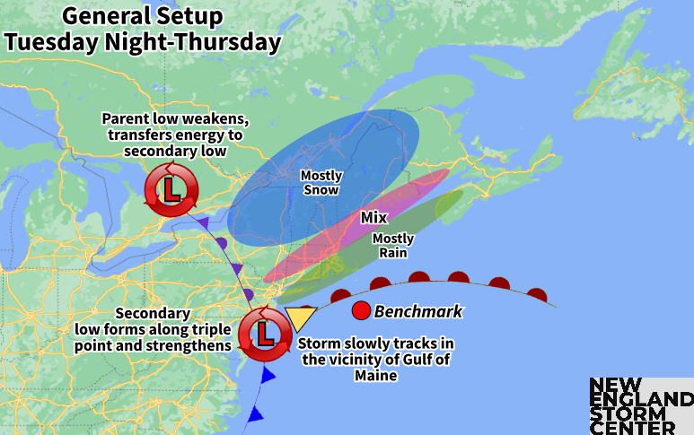
On Tuesday, the general setup for a potent storm system will begin to come together. The main storm system will approach the Great Lakes region and strengthen as it does so. At the same time, an area of high pressure will move to New England's north, allowing cooler air to filter into the region.
Tuesday has trended drier as the storm system will have to overcome dry air initially, which will delay the start of precipitation. Most won't see precipitation begin to fall until after dark Tuesday, though some rain showers will be possible across southwestern New England Tuesday afternoon.
Precipitation will likely continue to slowly fill in during the day on Wednesday. Precipitation will generally be light during the day on Wednesday with measurable precipitation likely holding off until the second half of the day. Overall, impacts during the daylight hours on Wednesday will be minor. Winds will begin to pick up throughout the day.
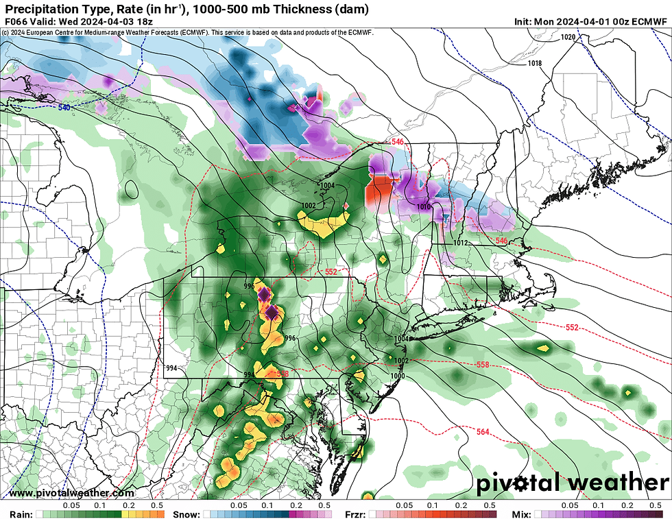
Expected weather Wednesday afternoon, showing scattered, lighter rain and snow showers filling in across New England:
The worst of the storm will be Wednesday night through Thursday night. This is when the heaviest precipitation, highest wind gusts and potentially minor coastal flooding will occur. Rain showers in central and northern New England will begin to mix with snow as the night goes on. The mix will likely change to all snow from higher elevations to lower elevations as well.

Precipitation rates will become heavy Wednesday night with snow to the north and rain to the south. This is when a bulk of the snow and rain accumulations will likely occur. At this point, the storm will likely stall out in the Gulf of Maine due to blocking downstream. This will allow precipitation to continue through the day Thursday with snow to the north and mix and rain to the south.
Expected weather overnight Wednesday night (1st image) and Thursday afternoon (2nd image):


With the downstream block in place, this system will slowly meander away. The system will likely remain close enough to produce more scattered showers (rain and snow) on Friday and even into Saturday as well, though the impactful weather will have ended by Thursday evening.
This is a tough call on snowfall, which is expected in early April. Heavy snowfall rates, mixing, varying snow ratios, warm ground conditions, strengthening sun angle, the storm track, the storm strength and the storm's duration are all working for and against each other for snowfall.
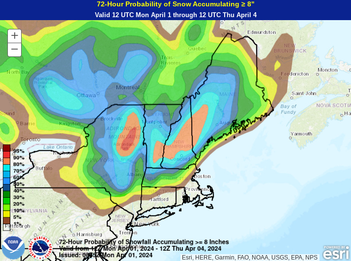
In the end, it's safe to assume elevation will play a role in snow totals, with the Green, White and Maine mountains seeing the most, with upward of a foot or more possible there amid drier snow. The New Hampshire Lakes Region into western Maine could also end up in the jackpot zone depending on where the final storm track is.
Probability of snow accumulating at least 8 inches by Thursday morning. Remember, this is a long-duration event and additional accumulations are likely through Thursday night, especially for eastern Maine:
Lesser amounts will be seen across areas farther south, with the highest chance for a plowable snow across central and southern New England being in the Berkshires and Worcester Hills. Lower elevation areas in southern New England (Connecticut River Valley, coastal plain) will likely see mainly a cold rain, but some very minimal accumulations can't be ruled out at this time.
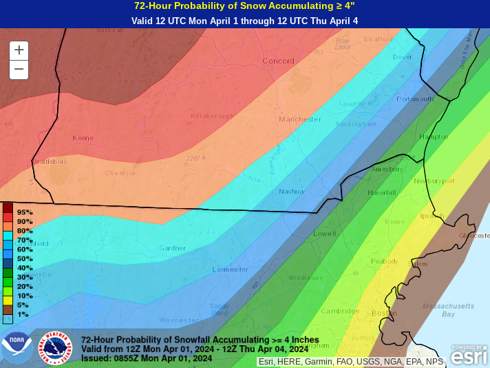
One big issue with determining snowfall is that there are growing indications of a potentially very sharp cutoff in totals setting up in central New England, mainly southern New Hampshire. This cutoff could be heavily influenced by the storm's final track, pushing it north or south. While there is a high chance of impactful snow across northern New England, central New England (southern New Hampshire, southern Vermont, northern Massachusetts) is much less certain at this point.
Probability of snow accumulating at least 4 inches for southern New Hampshire and northern Massachusetts, showing probabilities dropping from 80% near Manchester to 30% or less heading toward the coast:
Being April, this will likely be a wet, heavy snow for most outside of the mountains. When getting six or more inches of this kind of snow, there will likely be power outage issues across New England. Add in gusty northeast winds, and the potential only grows.
Some coastal flooding will also be possible. Tides are not astronomically high, but minor flooding with pockets of moderate coastal flooding will be possible. With an onshore flow and a strengthening low pressure system in the Gulf of Maine, it will be something to watch out for.
WEEKEND
Some lingering snow and rain showers are looking increasingly likely for Saturday, mainly in northern New England, but the whole region will remain under broad cyclonic flow, so everywhere will have the chance to see some light precipitation during the day. The day will also likely be breezy amid typical post-storm conditions.
Sunday will likely see improvements with more clearing and high pressure potentially building into the east coast. The one week outlook on the eclipse is certainly looking optimistic at this time. We need to keep watching the evolution of this week's storm system and for a potential cold front, but, as of now, at least partial sunshine is in the picture for Monday, if not mostly sunny for some. We have an eclipse weather hub that continues to be updated every evening. You can see that here.
1st weather map for the morning of April 8th:

Comments