New England Weather This Week: Dry Times & Wet Times
- Tim Dennis
- Mar 31
- 5 min read

This week will feature a back and forth with low pressure and high pressure, bringing periods of wet weather between nice days. Temperatures will generally be seasonable to mild with little indication of cold air.
MONDAY
An enhanced southerly flow will continue today as the main area of low pressure connected to this frontal boundary lifts northeast out of the Great Lakes tonight and north of New England on Monday. This will allow the boundary to lift northward as a warm front. This will promote additional rounds of rain showers throughout the day, most numerous across northern New England this afternoon. Pockets of freezing rain will continue to be possible across northernmost areas as surface cold air will be stubborn to let go.

The front will likely move into southern and central New England by Monday morning, allowing for a much warmer day compared to the weekend. Temperatures will likely rebound back into the upper 50s to mid 60s. Across the northern tier, it will likely take much of the day for the front to arrive. The warm front will also be weakening as it lifts into the area, so a sharp temperature contrast will be possible across northern New England. This contrast won't be as dramatic as the one across southern New England this past Saturday.
Areas north of where the warm front stalls out and begins to weaken (mainly New Hampshire north of Lake Winnipesaukee and much of interior Maine will likely be limited to the 40s to low 50s. A sharp temperature gradient will separate the warmer and cooler air masses; this gradient may set up near a line from Lake Winnipesaukee across interior Maine. Most of Vermont is expected to get within the warm sector.
Below: HRRR showing potential temperatures late this afternoon:

This long-duration weather event's final act will come Monday evening into Monday night as the area of low pressure to the north of New England drags it's cold front across the region. This will set off one last round of rainfall (this will be all rain everywhere) from west to east later Monday into Monday night. With New England in the warm sector and a robust cold front approaching, scattered thunderstorms embedded within the rain will be possible.
Below: Potential weather around mid-afternoon today (1st image) and overnight tonight (2nd image):

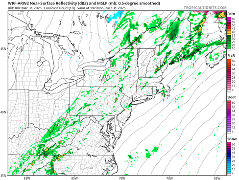


The line of rain and thunderstorms associated with the cold front tonight is responsible for an outbreak of severe weather across the Great Lakes. Meager instability over New England will lead to much tamer storms. There should be enough instability for some rumbles of thunder and lightning. The Storm Prediction Center has westernmost New England in a "marginal" risk (level 1 of 5) for severe storms. Southern New England will likely see a widespread half to inch of rain with a quarter to half inch across northern areas through Tuesday morning.

TUESDAY
The cold front will clear New England by Tuesday morning. It may get hung up near the coastline, allowing for shower activity to continue into the morning across Cape Cod and Downeast Maine, but it will clear out. Behind the front will see increasing sunshine through the day with cooler temperatures. It will be a breezy day with some gusty winds.
Below expected wind gusts early Tuesday afternoon:

WEDNESDAY & THURSDAY
High pressure will move overhead Tuesday night into Wednesday. This will bring about a cold start to Wednesday. Much of the day will be dry, calm and cooler under a ridge of high pressure and dry air. The day will see increasing clouds from west to east as the next system approaches for Wednesday evening through Thursday. A frontal system will slide across the Great Lakes on Wednesday and travel north of New England Wednesday evening through Thursday.

Initially, the air mass appears cold enough to support mostly snow across much of interior northern New England Wednesday evening and going into the first part of the night. As the warm front lifts northward, it will introduce a warm nose of air aloft, allowing for snow to switch over to a wintry mix from south to north. At this point, all precipitation types once again appear to be on the table with this one. Southern New England may be just cold enough to support a bit of sleet/freezing rain initially, but should quickly switch to plain rain.
The switch to plain rain will likely continue from south to north through Thursday until everyone is seeing rain showers by Thursday afternoon. As usual, the amount of wintry precipitation at the onset will come down to how quickly (or slowly) the cold air at the surface can scour out. With the system arriving in the overnight hours when temperatures are coldest, it could result in a quick hit of a few inches of snow and a glaze of ice across northern New England.
Below: Current probability of at least 2 inches of snow Wednesday through Thursday morning (1st image) and at least a glaze of ice Wednesday through Thursday morning (2nd image):


There will be plenty of moisture associated with this storm with more focused across northern New England, closer to the area of low pressure. With that said, this storm will be much more progressive than the current one that has been with us for a few days now. The storm will likely enter western New England Wednesday evening and depart eastern New England by Thursday evening. It will also have to eat away at very dry air over New England at the onset.
Southern New England will likely see lesser overall precipitation and this precipitation will be pretty much all plain rain showers. Much of southern New England will likely see much more scattered activity by Thursday afternoon. With New England in the warm sector on Thursday, high temperatures will once again be in the mid 50s to mid 60s. Temperatures will gradually drop moving north and east on Thursday as the warm sector stalls out.
Below: Euro showing potential temperatures Thursday afternoon:

FRIDAY
The system's cold front will drop through New England later Thursday into Friday morning. This may allow for lingering showers Thursday night and Friday morning. This front will be weak and with high pressure building in from the south and west, the air mass will not cool behind the passage. Friday will remain mild across New England, likely ranging from the low to mid 60s south to mid 40s north. These milder temperatures should be aided by increasing sun in the afternoon.
WEEKEND
High pressure slides north of New England to start the weekend. A wave of low pressure will likely slide through New England after this ridge passes, bringing another round of precipitation. Current trends have the high pressure holding on a bit longer, so Saturday could end up mostly dry.
Sunday once again looks to be the focus of more showers. This does look to be mainly rain with perhaps some elevation-based snow or mixed precipitation. The extent of this will likely come down to the timing of the system. Should it move in overnight Saturday to Sunday when its coldest, more mixing is possible versus if it moves in during the daytime Sunday.
Below: Current weather map for Sunday morning (April 6):


Comments