This week will be dominated by much more winter-like air than what New England has seen over the past couple weeks.
TUESDAY
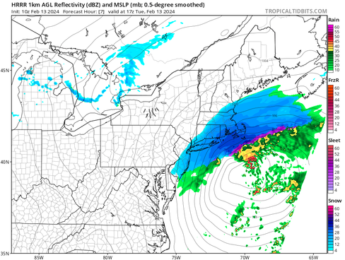
The saga that has been this storm will be reaching its climax today. Our snowfall map from last night still holds true this morning with New England's south coast seeing the heaviest of the snow with amounts steadily dropping as you head north.
A 3-5 hour window from mid-morning through mid-afternoon will have the potential to produce 1-2 inch an hour snowfall rates. This will result in a general 5-8 inches across the south shore, Rhode Island and southern Connecticut. Amounts will steadily drop off as you work northward.

Snowfall will likely peak in intensity and coverage around midday. With a heavy, wet snow, near whiteout conditions remain possible as winds begin gust 30-50mph with the strongest on Cape Cod. The storm will be a quick hitter, with most areas clearing out by the evening and some clearing out this afternoon.
Expected weather around noon (1st image) and 5pm (2nd image):


While much has changed with this storm over the past 24 hours, the coastal flood threat has remained on track (for the most part). Widespread minor coastal flooding is expected from Portland, Maine through Cape Cod. Pockets of moderate coastal flooding are possible across the eastern Massachusetts shoreline. The southward trend has lowered the coastal flood threat in northern New England.
Many coastal roads become impassable around the Tuesday afternoon high tide. Flooding of one to two will likely affect some coastal roads and low lying areas from Revere and Winthrop through Boston to the South Shore and into Cape Cod. A coastal flood warning is in effect from the Massachusetts North Shore through Cape Cod and the islands. A coastal flood advisory is in effect from the New Hampshire seacoast through Portland, Maine.

WEDNESDAY & THURSDAY
Wednesday will be cold and breezy as a northwest flow sets up behind the departing storm and a cold front. Highs will range from the upper teens across the northern tier to the upper 20s across southern New England. A wind chill will knock about 10 to 15 degrees off the actual air temperature. Some areas of northern New England may struggle to see wind chills climb above zero.
Expected wind chills Wednesday early afternoon:

Thursday will remain quiet with mostly sunny skies in the morning and building clouds in the afternoon. High pressure sets up for Thursday during the day and with the low pressure still departing to our east, it will be another breezy day. Highs will likely get a notch warmer Thursday, but it will remain cold with wind chills again coming into play.
Heading into Thursday night, a clipper system will likely slide through New England. With a fast, zonal mid-level flow in place, this system should zip through New England quickly and remain weak. Light snow showers and minor accumulations will be possible.

FRIDAY & WEEKEND
The system will likely move out by Friday morning with lingering snow showers a possibility in the mountains. Friday during the day will likely be similar to Thursday in regards to cloud cover and temperatures. A colder air mass sinks south for the weekend, but at this time, it does not look like a full-fledged arctic blast. It will once again be breezy, leading to wind chills below the air temperature.
The overall pattern will remain unsettled, with another brief and weak clipper system sliding through the region Saturday morning, bringing another round of scattered snow showers. With zonal flow in place leading to quick-hitting and weak systems, there remains a lot of uncertainty in timing and coverage of any snow showers this weekend.
Weather map for Saturday morning:

Comments