The week starts off chilly, but a warming trend is likely as the week progresses. The week will also be very quiet and tranquil, at least until the end, when a system likely pushes through the region. Here's the details:

MONDAY & TUESDAY
An area of low pressure to New England's north will drag its cold front across the region this morning. This will help keep New England under a north-westerly flow and chilly for the day. The front will bring a very dry air mass into New England, leading to a mostly sunny day for most of New England. Eastern Maine will see more clouds due to the departing system.
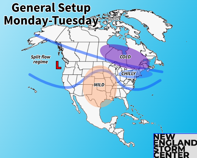
High pressure begins to build in on Monday and will dominate New England's weather for much of this week. This will keep the weather very quiet and dry with nothing of note to speak of during this time frame. Highs will be in the 20s and 30s. Morning lows will be cold, ranging from around zero in the higher elevations to the low 20s in southern New England.
WEDNESDAY & THURSDAY
By Wednesday, the polar jet stream will begin to retreat north. High pressure will move to New England's east, allowing a southerly flow. This will help temperatures climb quickly on Wednesday after a cold start for most.
More mild air that's across the center of the country will gradually spill eastward, signaling a warming trend for the rest of the week. Highs will jump above average on Wednesday, into the 30s north and 40s south. Thursday will be very similar, but likely ticking a notch warmer.

Wednesday should see another day of mostly sunny to partly cloudy skies. Thursday will see clouds increase ahead of a storm system entering New England Thursday night. This system is looking to be more on the mild side, but some mixing and snow could occur at the onset Thursday night in the higher elevations.
FRIDAY
The system sliding in on Thursday night will likely spread precipitation from west to east during the day on Friday. This does look to be a more mild system for most, with mainly rain showers for southern New England and areas closer to the coast. As expected at this time, there remains a spread in guidance among major models.
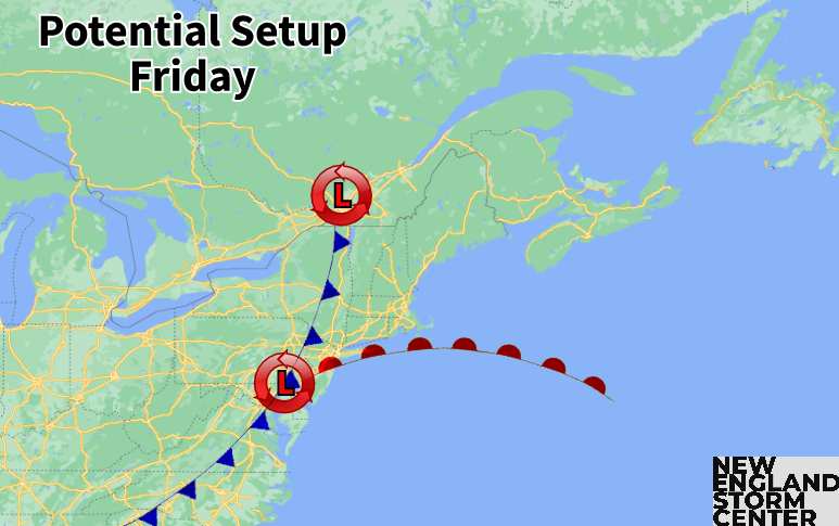
As always, we need to watch for a surface, coastal low to form. This would support a colder storm and more widespread frozen precipitation. As of now, it does look like the areas that have the best chance at seeing some frozen precipitation will be interior portions of northern New England, particularly the higher elevations.
While the system needs to be watched for the rest of the week to get details, this system could see snow or mixing at the start in higher elevations before a changeover to rain takes over for nearly everyone by Friday afternoon.
Overall, this system does appear to be a quick-moving system without blocking in place to keep the system around. As of now, signals are not showing an overly impactful system as northern and southern streams fail to phase. As always, we need to watch the trends throughout the week.
Model roundup (Euro, GFS, CMC and ICON) for Friday afternoon. As always, don't take any one of these verbatim at this point:


WEEKEND
The most certain part about this late week system is that it will help usher in a colder air mass once again for the weekend. Highs will likely drop off to the 20s north and 30s south after the mild end to the work week. This will come as a cold front gets dragged across New England, returning the region to a northerly flow. The weekend looks dry at this time, except for some typical upslope snow showers in the mountains.
Weather map for Saturday morning:

BEYOND
The post-system cool down does appear to be very short-lived as early indications do show temperatures rebounding back to above average levels for the end of February and week two of New England's school vacation weeks. The weekend cool down looks to be more of a brief anomaly in the long-term pattern.

Comentarios