It'll be another active week for New England with multiple systems moving through the region. Most of the week will generally be on the milder side, but another sharp cold snap looks to be coming heading toward the upcoming weekend.
MONDAY
After a compact and weak disturbance slides through southernmost New England in the morning, bringing light precipitation, the remainder of the daylight hours Monday will be dry. This already weak system basically ran into a brick wall that is the strong high pressure offshore. The rest of Monday will likely remain cloudier than not for most.
Heading into Monday night, a fast-moving frontal system will slice through New England from west to east. This system will lift a warm front through New England, increasing the southerly flow and allowing for mild temperatures to filter into New England. This will bring mainly rain showers for all of New England overnight Monday to Tuesday morning.
Below: GFS showing potential weather very early Tuesday morning:

The departing high pressure may provide enough cold air to keep the surface sub-freezing at the start of the event. This may allow for a period of freezing rain across interior northern New England early Tuesday morning. Icing would be very light with no more than a glaze. Probabilities of 0.01" of ice are currently capped at 40% and probabilities of a tenth of an inch remain at 0% region-wide. This will be plain rain from start to finish in southern New England and the northern New England coastal plain.
Below: Probabilities of at least a glaze of ice Tuesday morning:

This system will have a decently strong low-level jet to transport deeper moisture from the south into New England. This will allow for a period of steady rain across the region Tuesday morning into the early afternoon. A widespread tenth to quarter of an inch of rain is likely with some areas likely getting a bit more.
The strong low-level jet could allow for gusts up to 50mph in northern New England, however, an inversion will keep the strongest winds from mixing to the surface, so this won't be a major wind event. Wind advisories could still be posted later today in spots; this would be most likely in Vermont.
TUESDAY
The frontal system is fast-moving and will likely be just about wrapped up for much of New England (outside of Maine) by early to mid-morning. Eastern Maine may take until around midday to early afternoon before the storm moves out of New England completely. The air mass will remain mild after the rain moves out, and with a few breaks of sun temperatures will climb into the 40s north and 50s south. Some typical warm spots of southern New England may be able to push toward 60°.
Below: Temperature departure from average Tuesday afternoon, showing temperatures 10-15° above average:

The system's cold front pushes through New England during the day, but it's a rather weak front and temperatures will take time to drop behind it. The air mass behind the front overall isn't very cold, either. A secondary round of gustier winds will be possible with the front's arrival through the day.
WEDNESDAY & THURSDAY
Much of Wednesday will be similar to Tuesday, though several degrees cooler thanks to the preceding cold front. The day will likely end up mainly cloudy, but dry. New England's next system will begin to move into western New England toward the evening. This system will involve a trough of low pressure racing from the Tennessee Valley through the northeast within 24 hours. A northern stream system will scoot from the Great Lakes to the north of New England during this time.

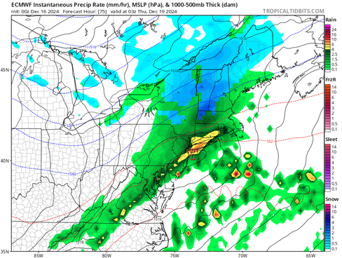
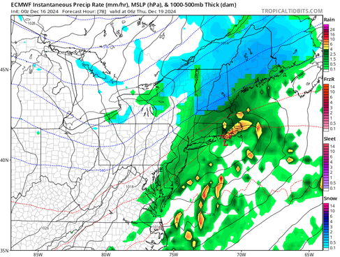
Guidance has begun to come into some semblance of agreement on a track near Cape Cod. This track inside the benchmark will favor more by way of rain across much of southern New England, snow across much of northern New England and a mix zone in between. Tuesday's cold front will provide slightly colder air, but temperatures will be marginal across the region. These temperatures, close to freezing, will mean subtle shifts in the track could lead to big differences in the outcome, especially in the "battle zone" on the map above.
Temperatures will initially be above freezing for most Wednesday afternoon and evening. This will allow many to see rain or a mix at the onset. Through Wednesday night, the temperature will drop and precipitation rates will increase, allowing the rain/snow line to inch southward. How far south the rain/snow line gets will be determined by the storm's final track. The farther south the storm tracks, the farther south the rain/snow line will get pulled.
Below: Euro showing potential weather early Wednesday night (1st image) and the middle of the night (2nd image). You can see the rain/snow line generally inching south:
This is one of those situations where a more northerly track in the storm would favor a stronger storm with more phasing with the northern stream and more precipitation. This solution would result in heavier precipitation, but also stronger warm air advection, pushing the rain/snow line farther north. A more southerly track would be a weaker storm with less phasing of the northern stream. This would be a colder storm, but with less precipitation.
Either way, this is unlikely to be a major event by way of snowfall or rainfall. Guidance is tending to favor the middle ground between the above scenarios. These scenarios are why subtle changes in the track will lead to larger differences in the outcome. As of now, northern areas of New England are favored to see a few inches of snow.
The fact that this is unlikely to be a major event can be seen with snowfall probabilities dropping significantly when going up to 6 inches. A gradual drop in snowfall is expected moving southward with minimal snowfall in the higher elevations of southern New England and no snowfall in the lower elevations of southern New England.
Below: Probability of seeing at least 2 inches of snow by Thursday morning:

Another major limiting factor for both snowfall and rainfall is the fact that the storm will be moving along quickly. The Storm is forecast to be moving around 50mph, leading to a quick hit. This will only allow for several hours of steady precipitation. The storm will steadily wind down from west to east Thursday morning into the early afternoon. Typical upslope snow showers in the mountains will continue through much of the day Thursday.
FRIDAY & WEEKEND
Friday will be a colder day with another brief dry interval between systems. The second half of Friday through Saturday will feature two main weather features. How these features interact with each other will determine much about what to expect in New England. These features are a northern stream clipper-like system and a southern stream coastal storm well offshore.

Should the clipper system and coastal system stay separated, it would likely bring some scattered snow showers to parts of New England Friday into Friday into Saturday morning. Should interaction or phasing occur between the systems, it could lead to a more complex system with heavier precipitation rates. Most guidance continues to keep these systems separated for now, but there is plenty of time for change at this point and significant differences in timing and evolution of this remains within guidance.
The timing of any interaction will also be important. If the two begin to phase together, but too far to the east of New England, it would result in some scattered snow showers, similar to if the two don't interact at all. The reasoning behind all this is that if the two interact, it would inject subtropical moisture into the clipper, resulting in more precipitation.
Below: Current likelihood of at least minor winter weather impacts during this time frame:

Regardless of how the precipitation plays out this weekend, it will swing the door wide open for an arctic air mass to enter the region. As of now, Sunday looks to be the peak of the arctic air, with high temperatures poised to range from the single digits north to low 20s south.


Comments