New England Weather Patterns & Terminology: What it All Means
- Tim Dennis
- Aug 5, 2023
- 5 min read
At New England Storm Center, we like to get into why the weather will be the way it will be, not just what it's going to be. Here's a look at the meteorological features and words we tend to bring up in forecast posts (underlined terms are in alphabetical order):
Blocking pattern: A weather pattern in which areas of low and high pressure get stuck. This can lead to the same weather being experienced for days (or even weeks) on end. Depending on what "side" of the block you're on, this could be very pleasant or not so much. Blocking patterns are most common in the spring time.
Types of blocking patterns
-Greenland Block: When a strong area of high pressure sits over (or near) Greenland. The jet stream is forced to take a southward dip over the northeastern United States, causing cold, unsettled weather, particularly in the winter.
-Omega Block: When two low pressure systems become cut off from the jet stream and an area of high develops in between them. This causes warm and dry conditions in the area of high pressure and cool, unsettled weather in the areas of low pressure.
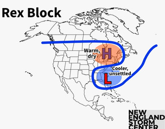
-Rex Block: When an area of high pressure develops directly (or nearly directly) north of an area of low pressure. This can lead to an unusual bend in the jet stream and create warmer, drier conditions in the north and cooler, unsettled conditions in the south.
-Ring of fire (heat dome): When hot air becomes trapped in the same area, typically around a strong area of high pressure. We typically use the term "heat dome" over "ring of fire".
The four main blocks visualized:


Convection: The transport of heat and moisture by the movement of a fluid. This often creates thunderstorms. Convection can also just lead to cloud formation without thunderstorms developing.
Convective Available Potential Energy (CAPE): A measure of the amount of energy available for convection. Favorable environments for thunderstorms will often see CAPE values exceed 1,000 joules per kilogram. We very rarely bring this up in forecast posts.
Frontal Boundary: The separation between two air masses. When two different air masses meet, it will often result in rain, clouds, storms and/or gusty winds.
Types of fronts
-Cold front: The cooler, more dense air mass is advancing and replacing a warmer one. This happens often in New England and can result in thunderstorms in the summer and snow showers or squalls in the winter. In the summer, cold fronts will typically replace hot, humid weather with slightly cooler and much less humid weather. In the winter, these fronts can be very strong, causing temps to plummet and bring very high wind gusts.
-Backdoor cold front: A cold front moving more in a westerly direction instead of the typical easterly direction


-Warm front: The warmer air mass is advancing and replacing a cooler one.
Pressure Systems:

High Pressure: An area where atmospheric pressure is higher than surrounding areas. Winds diverge (or move away) from the center. These systems are marked by a blue "H" on our maps, sometimes with arrows surrounding it to show wind direction. High pressure results in clear, stable weather, opposite of low pressure.
-Ridge: An elongated area of (relatively) high pressure that does not have a clear center. Ridges tend to feature warmer, drier weather.
Low Pressure System: These are storm systems. It's an area where atmospheric pressure is lower than surrounding areas. Winds converge (or move toward) the center of the system. These systems are marked by a red "L" on our maps, often with a circle of arrows around it, showing wind direction.
Types of low pressure systems
-Closed low: An area of low pressure that has a clear center of circulation.

-Cutoff low: An area of low pressure that has completely detached (or cut off) from the main flow. The main flow runs west to east, causing storms to move west to east. When a storm becomes cut off, these storms can sit over the same place for days on end or even move east to west, opposite of the main flow.
-Trough: An area of (relatively) low pressure that does not have a clear center of circulation. The system is typically more elongated than a closed low. Troughs tend to result in cooler and unsettled weather.

Nor'Easter: A storm system where wind direction is from the northeast. These are New England's hallmark storms that bring the region heavy snow, rain, high winds and coastal flooding.
Precipitable Water (PWAT): The amount of water vapor contained in a column of air if it were to be condensed and collected. Basically, the higher the PWAT value, the heavier rainfall rates could be. We rarely bring this up in forecasts, and only do so when PWAT values are extraordinary.
Shortwave (energy): A disturbance in the mid or upper part of the atmosphere which induces upward motion ahead of it. A shortwave may produce rain and/or thunderstorms in the area affected. We'll usually use the term "energy" in place of shortwave.
Warm sector: An area of warm, usually moist air in between a warm front and a cold front. This area is typically where showers and storms break out ahead of an approaching storm system.

Understanding event magnitude
When looking at one of our forecast maps, we use the terms isolated, scattered, numerous and widespread. This is what those labels mean (overall threat is on a scale of 1 to 5):
Isolated (overall threat 1-1.5): There is generally a low chance that the forecast weather event (severe thunderstorms, flash floods, etc.) will occur in the area, but a couple areas may experience it.
Scattered (overall threat 2-2.5): This is typically the area that has the best chance to see issues from the forecast weather. Not everyone in this area will see issues, but a decent amount will.
Numerous (overall threat 3-3.5): This label (and the next one) aren't used very often, and when we do include them, it means there is an overall heightened risk for adverse weather. Many people in this area will see issues from the forecast weather event, some may see major issues.
Widespread (overall threat 4-5): A rarely used label that indicates a very intense weather event for the area. A majority of people in the area will see issues, many people will likely see major issues. During flooding and wind events, we may use the term "severe" instead of "widespread" to better convey the seriousness of the situation.
Forecast map for the historic flooding event of July 2023 (notice that we did opt to replace the term "widespread" with "severe"):

Further reading:
Comments