New England's Upcoming Weather: An (Almost) Perfect Weekend
- Tim Dennis
- May 25, 2024
- 3 min read
Saturday will feature about as perfect weather as you can get with 70s to low 80s dominating across New England and mainly sunny skies. With a weaker flow, a sea breeze will be able to kick up and cool the coast to the 60s in the afternoon. Northern Maine and New Hampshire will also likely stall out in the 60s.
Sunday will be very similar temperature wise. There will be a few more clouds around as a weakening system passes through New England. This system may bring a quick round of showers in the morning. After that, partly cloudy skies will be dominant in the afternoon. Energy from the passing system combined with daytime heating could trigger a few storms in the afternoon. The best chance for storms will be near the system's front.

Coverage of storms is very unlikely to be widespread. Activity should be more isolated with more areas not seeing a storm than seeing one, even in the yellow shading above. With that said, there will be parameters in place that are conducive for some storms to get on the stronger side. While lift and moisture will be present, shear will be limited.
Instability will also be present with CAPE values potentially getting over 1,000 in southern New England, although full CAPE potential may not be realized due to an inversion. Sunday afternoon will be one of those "keep your eye to the sky" kind of days.
WRF-ARW showing the potential for a few storms to develop later Sunday afternoon:

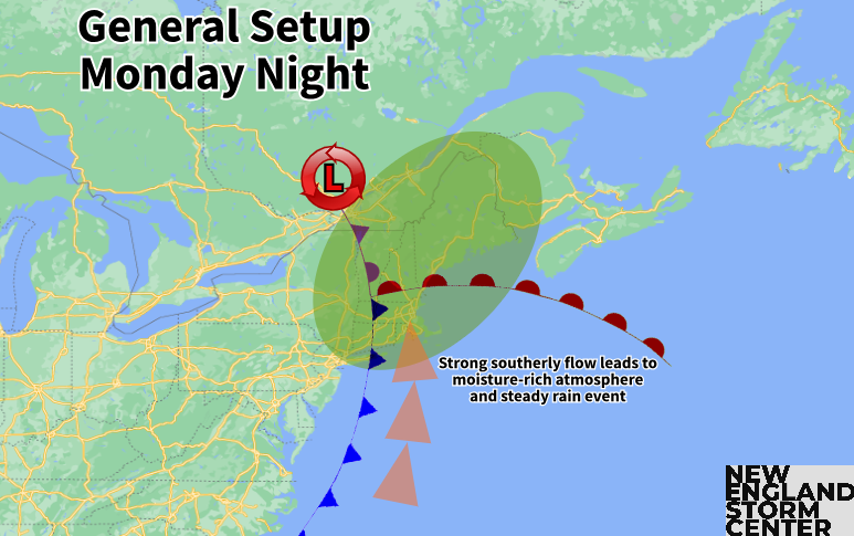
A more large-scale system will begin to move toward New England from the Great Lakes on Monday. With that said, the steadiest rain will impact New England overnight Monday to Tuesday morning as the system drags its front across the region during the overnight hours.
Memorial Day itself will be overcast and cooler with light showers breaking out ahead of the system, but the daylight hours will not be washed out. Showers will move generally from west to east, so western areas will see more by way of showers activity Monday afternoon.
Euro showing potential weather Monday afternoon:

As stated before, the bulk of the storm will be Monday night to Tuesday morning. The storm is looking to bring a widespread steady rain, but rainfall amounts are not overly impressive at this time, with a widespread half inch to one inch of rain currently expected. A dry slot is looking to quickly move into New England, which will help limit total rainfall. With that said, the atmosphere will be moisture rich as the system moves well inland of New England, leading to a southerly flow.
Expected rainfall Monday night:

There is the potential for the development of some thunderstorms during the course of the system. Should storms be able to develop, it would be able to produce brief bouts of torrential downpours. For this reason, the Weather Prediction Center has all of New England in the "marginal" category (level 1 of 4) of excessive rainfall for Monday night.
For the rest of next week, the northeast may stay under a trough and broad cyclonic flow as a bit of a blocked up pattern looks to form with troughs in the east and west and a ridge building in the center of the country. This will prevent summer-like heat from building into the region next week like it did this past week, but mainly seasonable temperatures can be expected at this time with 70s dominating. It does look like it will turn cooler heading toward the end of next week. The trough could also keep unsettled conditions around.
Euro 500mb height anomaly through next week showing general troughing over the northeast persisting:

Comentarios