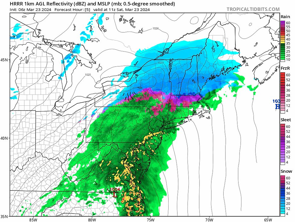
New England's storm remains on track this morning with snow falling across northern New England and a wintry mix and rainfall in southern New England. The mix line is slowly working its way northward. Bouts of heavy snow will continue all day across areas north of Lake Winnipesaukee. The northern and southern stream storms have begun to phase together this morning.
HRRR showing hourly weather from 8am Saturday through 6am Sunday:

A prolonged period of sleet and freezing rain will occur in higher elevations of central New England as a warm air layer of air aloft rises over a cold surface layer. The coastal plain of central New England will see above freezing temperatures all the way to the ground by this afternoon, allowing a transition to plain rain.

Freezing rain amounts have increased just inland from the northern New England coast. Some isolated areas in this swath could see up to four tenths of an inch of ice. There are factors working against significant ice accretion, so a full-on ice storm remains unlikely. These factors are why we opted not to add a 0.25-0.5" of ice on our map below. The area that will have the chance to see a quarter inch or more is a narrow band. The higher elevations of southern New England could see freezing rain hold on into the early afternoon before switching to plain rain.

Heavy snow remains on track for northern New England. We added a small 18-24 inch zone in northern Maine to reflect the increasing possibility of some areas seeing over 18 inches. Most areas will likely remain at a foot and a half or less. Areas that see greater than 8 inches of snow across central New Hampshire and Vermont will likely see power outage issues with heavy, wet snow. The snow will likely be drier further north, which will help limit how much snow weighs down branches.

The heaviest of the snow will generally be through the afternoon in Vermont, the evening in New Hampshire and the evening into the first part of the night for eastern Maine. Areas will likely see a burst of heavy snow toward the end of the event before quickly winding down thereafter.
An avalanche warning has been issued for the Presidential Range of the White Mountains. This is in effect through 5am Sunday as the mountains are expected to see at least twenty inches of snowfall.
A widespread 2-3 inches of rain remains likely for southern New England with areas of Connecticut and Rhode Island likely surpassing three inches. This will lead to scattered flooding issues, although no major flooding is expected. A handful of rivers may reach minor flood stage with the Pawtuxet and Wood River in Rhode Island pushing toward moderate flood stage.

A wind advisory has been posted for New England's south coast. Gusts will generally remain below impactful levels, but some gusts up to 50mph will be possible. The storm will quickly wind down on the backside, with snow and rain shutting down by midnight for most outside of Maine. Eastern Maine will see precipitation come to an end by sunrise Sunday.


Opmerkingen