A storm will be impacting New England right before Thanksgiving this year. While details still need to come into focus regarding the track, the general idea of how the storm will play out is starting to come into focus. Here are the current trends with how the storm will play out. Remember these are trends, not a locked in forecast.
Summary: This storm continues to look like a steady rain event for southern New England and the lower elevations of northern New England. Much of New England could see some snow/mixing at the start before a transition to rain begins generally from south to north. Some parts of northern New England could see a few inches of snow. Overall plan on slower travel on this busy travel day.
Models have been very consistent since the storm first came into view early last week that the storm would impact New England Tuesday night through Wednesday. This remains the most likely outcome. The storm's setup involves a primary low tracking well north of New England with a secondary low forming near the Mid-Atlantic. This setup is important since the track of the southern low will play a large role in determining precipitation types.

Speaking of precipitation types, it looks like southern New England is in for a mainly rain event. Some frozen precipitation may mix into the rain in the higher elevations (Berkshires, Litchfield Hills and Worcester Hills) on Wednesday. These areas may start the storm as all snow, but it is currently looking these areas will switch to rain or wintry mix before any kind of notable accumulation.
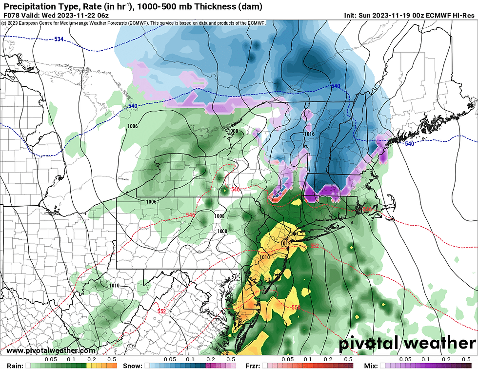
Euro model showing potential weather overnight Tuesday to Wednesday:
For northern New England, the storm is currently looking to start as snow or a mix for just about everyone. With the current track, which models are starting to agree on more, the wintry weather would switch to rain starting from the New Hampshire and Maine coasts early on, and gradually work inland and north as Wednesday goes on. How quickly the snow changes to rain and just how far north the rain/snow line gets will be determined by the southerly low's ultimate track.
Euro model showing potential weather Wednesday morning (1st image) and Wednesday afternoon (2nd image):


The further south that low tracks, the further south more snow will fall. The further north it tracks, the further north the mild and rain will get. Right now, models are having the southerly low passing near New England's south coast/Long Island. This would support a changeover to a mix/rain for all except the White Mountains and northern Maine.
As far as how much snow and rain to expect, it's too soon to make any kind of detailed snowfall forecast, but a couple inches may be possible across the higher elevations of southern New England and northern New England away from the coast. Several inches of snow will be possible across the Green and White mountains, possibly the lakes region northern Maine. This doesn't look like a major snow event, with currently very low probabilities of anywhere seeing 6+ inches. There will likely be a widespread inch of rain in southern and central New England.
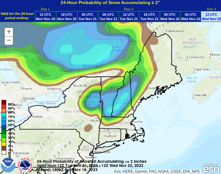
Probability of seeing at least 2 inches of snow by Wednesday morning. Areas shaded in blue have a moderate chance while areas outside the blue have a lower chance:
Wind will also be a factor, with the highest winds expected closer to the southerly low, which would be the south coast, particularly Cape Cod and the south shore of Massachusetts. Gusts here could reach up toward 50mph. Elsewhere, gusts of 25-35mph will be possible, with the strongest near the coast.
As for overall timing, models have been in decent agreement about the onset beginning Tuesday evening with the storm winding down from west to east Wednesday evening through Thursday morning. It does look like the storm will be gone and over by Thanksgiving. Typical upslope snow showers will likely continue Thursday in the mountains.
Comments