A brief shot of cold air will lead to a very chilly Saturday for New England, with pretty much everyone remaining below 40°. With light winds and sunshine, it shouldn't feel too cold out there. It will be another cold night Saturday to Sunday before a more mild Sunday afternoon. Clouds will be on the increase through Sunday.
New England's next storm system will be coming Sunday night into Monday. This storm's setup will be similar to the pre-Thanksgiving system with a primary low tracking to the north of New England and a secondary, coastal low strengthening while it passes close to Cape Cod and then into Maine. This system will be a low impact system for most.

With coastal storms in the colder months, the track of the system plays a massive role in wh precipitation type New England sees. The closer the storm passes to New England, the more mild the storm tends to be, leading to more rain and less snow. With this system likely passing over (or close to) Cape Cod, this will be primarily a rain event.
This storm will be all rain for all of southern New England. A couple of flakes could mix in at the very beginning in the highest elevations, but that's about it. Where the heaviest of rain falls will be determined by the system's ultimate track. A band of heavier rain will likely fall on the north side of the center of the low's track. Right now, this band is most likely to fall along Cape Cod and the south shore as well as downeast Maine. Overall, significant, flooding rainfall is not anticipiated.
Expected weather overnight Sunday (1st image) and Monday morning around sunrise (2nd image):

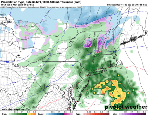


Much of New England will be looking at a widespread half an inch to inch of rain, with the most in the areas mentioned above. There will be less rain across Vermont and where the system starts as snow, which would be across the Green Mountains, northern New Hampshire and northern Maine.
Even these areas, except for the higher elevations, will see snow mix with, or changeover to rain Monday morning. As stated yesterday, a couple inches of snow is possible across these areas, with the most falling at elevation. The valleys in northern areas will likely see less snow and more rain.
Probability of seeing at least 2 inches of snow. It's worth noting that the probability of seeing at least 4 inches of snow is currently below 50% for everyone:

This system will be a quick-hitter, arriving in western New England in the overnight hours Sunday into Monday and departing eastern Maine by Monday evening. Most areas outside of Maine will likely see rain wind down Monday afternoon.
Expected weather Monday afternoon:

Overall, this should be a rather low impact system with sub-flooding level rains, minimal snowfall and winds looking to remain below impactful levels. Some minor splashover will be possible across the New Hampshire seacoast through Maine's midcoast with astronomical high tide occurring Monday morning.
After this system, New England will remain in a trough, bringing chilly weather, breezy conditions and a chance for mountain snow showers throughout next week. Outside the mountains, it will be dry and partly cloudy along with the aformentioned chill and breeze. Overall, next week is looking to be a quiet one.
Comments