New England has seen a couple unusually long stretches of dry weather this spring, especially southern New England. Much of southern New England is running a deficit on rainfall so far this year. The region's latest stretch of rain free weather will be coming to an end this weekend.
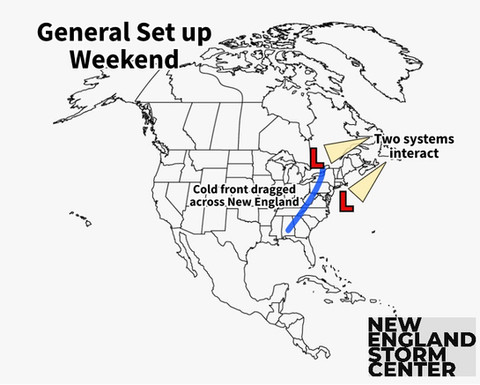
This weekend's wet weather is being set up by two systems. First, a rather weak area of low pressure will move offshore of the Carolinas and begin working up the coast. While this happens, a stronger area of low pressure will track across the northern tier of the country and move north of New England. This track will drag an associated cold front across our region. These two systems will interact and reinforce each other Saturday night.
Here's a look at the general set up. This set up can be seen on the model in the second image:


The passage of the cold front, which is when the most rain will fall, looks to happen Saturday evening through early Sunday morning. Showers will likely break out Saturday morning to midday as the initial area of low pressure off the coast arrives. Showers will likely linger into Sunday morning, but much of New England should be drying out by Sunday afternoon.
This storm is looking to give New England a pretty decent soaking, which is needed for the parched southern New England. This will also put a nice damper on a recent wave of brush fires that have broken out across Massachusetts this week.
This will not be a repeat of northern New England's flooding event that took place at the beginning of the month. A widespread half an inch to three quarters of an inch of rain is looking to fall across New England.

Coastal New England is looking to get the most out of this event, with an inch possible in Rhode Island, eastern Massachusetts, the seacoast of New Hampshire and coastal Maine. Vermont, mainly northern Vermont will see the least amount of rain as this is where a dry slot is expected to develop.
There could be some areas that see isolated amounts closer to two inches in the foothills and mountains of New Hampshire and western Maine where upslope enhancement is always a possibility. The storm is a quick mover, so flooding is not much of a concern at this time. As stated before, this storm is not a repeat of early May's flooding event.
TIMING
Saturday morning: Scattered showers break out, Maine stays dry for now.
Saturday afternoon: Showers become more widespread, scattered showers break out in Maine.
Saturday evening: Steadier rain begins to break out.
Saturday night: Bulk of the rainfall.
Sunday morning: Showers continue.
Sunday afternoon: Drying out begins.