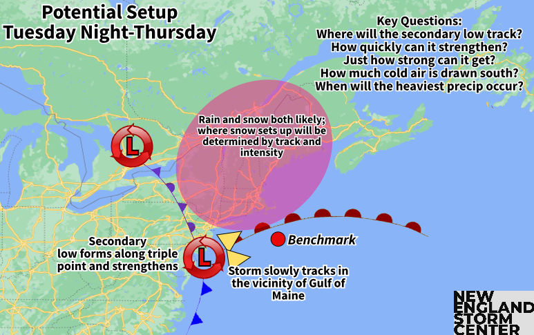
As this system (a northern stream energy piece) moves northeast toward New England, interaction with the southern stream will help spawn a secondary low somewhere south of New England. This low will strengthen and become the primary low. This system will likely slowly crawl along in the vicinity of the Gulf of Maine, leading to a prolonged event as blocking to the east will lead to a slow departure.
Over the past 24 hours, the storm has taken a generally northward and cooler trend. This increases the chances for snowfall to take on a heavy elevation-based influence. Snowfall will likely be greatest across interior portions of northern New England (with lesser amounts in the valleys) and potentially extending southward into the Worcester Hills and Berkshires.
When it comes to how much, this storm will be moisture-rich, which will allow for bouts of heavier snow at elevation and steady to heavy rain in lower elevations. Snowfall could potentially come in the 6-12+ inch range for portions of the White, Green and Maine mountains. This could also bring another 1-2+ inches of rain to southern New England. The track of the storm will determine much when it comes to this storm, and there is still quite a spread in where the track will end up.
Weather Prediction Center probabilities of impactful winter weather from Wednesday morning through Thursday morning, showing probabilities now up to 70% for the higher elevations of New Hampshire and Vermont:

This storm's evolution is complex and it will be a long-duration event. Precipitation will likely arrive on Tuesday night and last until Friday in some places. The initial onset will likely be rain showers for most with a transition to snow happening from higher elevations to lower elevations on Wednesday or Wednesday night. Rain and snow will likely continue for much of Thursday as the storm stalls in the Gulf of Maine. This storm could end up making a loop over New England due to the blocking.

As with any spring storm, snowfall amounts will be tricky to pin down. This is because temperatures will be marginal, leading to a wet, heavy snow outside of the higher peaks. This snow compresses as it falls and is difficult to pile up in large quantities. Models can have trouble determining snowfall amounts anytime of year, but especially in the springtime, when snow-liquid ratios (SLRs) will likely be low.
SLRs basically determine how much water is being held within the snow. The wet, sticky snow has more water content, leading to a lower ratio. Most models predict straight snowfall by assuming a 10:1 SLR. This means that for every 10 inches of snow, there would be one inch of water within the snow.
In these spring storms, the ratio will likely be lower in many areas, leading to lower accumulations than what is being produced by models using a 10:1 ratio. Trying to determine what the ratios will be across New England will make determining snowfall amounts a challenge to determine.
This storm will also have the potential to bring a soaking rain to southern New England, especially at the lower elevations, potentially renewing some river flooding in areas that saw multiple inches of rain last week. Gusty northeast winds will also be likely with this storm, especially near the coast.
Here's the Euro model's interpretation for what will happen from Tuesday afternoon through Friday afternoon. Remember this is one model and not locked in:

Comments