New England's Infamous Looping Storms
- Tim Dennis
- Nov 12, 2023
- 4 min read

Updated: Nov 12, 2023
Many of New England's most powerful storms come in the form of a coastal storm, whether it be a tropical system or a non-tropical nor'easter. These storms often ride up the east coast, paralleling the coastline until they slam into New England before continuing to race northeast into the open northern Atlantic or Nova Scotia. Every so often, however, something keeps these storms from making a timely exit.

In many cases, these storms, having nowhere else to go, make some kind of loop over or near the region instead of racing away. There is one factor that almost always plays a role in looping storms: high pressure. High pressure systems often act as a major steering current and blocker for storms. The clockwise flow around high pressure can counteract the natural west-to-east and south-to-north movement of systems.
This can be seen best by looking at the movement of 1991's Perfect Storm. An area of high pressure well to the east of New England in the open North Atlantic kept the system from moving eastward when it initially formed off the coast of Nova Scotia.

As the storm continued to move in a southward direction, a very strong area of high pressure formed to the north of the storm, helping to steer the storm in a westward direction, back toward the eastern United States. The storm would eventually be sandwiched between two high pressure systems. The northerly high pressure would eventually pull away, allowing The Perfect Storm to begin to move in a more conventional northeast direction.


The Perfect Storm is an exceptional case of not only a looping storm, but just an exceptional storm in general. The description above didn't even go into the storm's interaction with Hurricane Grace or the transition from a nor'easter to a hurricane. Another example of high pressure systems helping to cause looping storms include the infamous Blizzard of 78, which was moving in a very traditional northeast direction until it was off the New Jersey coast.
At this point, a strong area of high pressure over the central United States and a nearly stationary area of high pressure over Greenland helped create a barrier to slow the storm down. The loop was further aided by another area of low pressure that dropped out of the Great Lakes and was absorbed by the main low off the coast. This low out of the Great Lakes (or trough) helped pull the coastal low to the west, causing a loop before continuing to move east-northeastward.
Blizzard of '78 components:


In October of 2021, a nor'easter took a similar path to the Blizzard of '78, complete with a loop. The reason this storm looped was thanks to an area of low pressure that was moving across the northeast United States at the time. The coastal low absorbed this low, very similar to what the Blizzard of '78 did. Troughs of low pressure that move over the northeast can often "tug" coastal storms to the west, back toward land.
October 2021 storm path:

The key to this occurring is timing. The timing of both the trough moving over the northeast and the coastal storm (either tropical or non-tropical) has to be just right for a storm to get pulled westward. If the coastal storm moves up the coast too long after a trough enters the northeast, the trough will have the opposite effect: it will help push the coastal storm further away.
Some tropical systems have seen this effect. Many hurricanes and tropical storms have been deflected away from New England thanks a trough already in place over New England or a cold front pushing through the region. There are some tropical systems that have been pulled toward New England, Lee in 2023 was pulled slightly toward New England, though not enough to create a dramatic westward bend in the track.
Tropical Storm Henri in 2021 got wrapped up in the circulation of a mid-level low pressure system just inland of the Mid-Atlantic. Henri followed the flow around this mid-level system, causing it to make landfall in Rhode Island before turning due west. Once the low loosened its grip, Henri was able to loop back around and exit to the Atlantic (in a much weakened state).

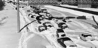
These looping storms often become infamous, not necessarily because of the loop itself but because the circumstances that help create the loop can often lead to intense strengthening of the storm. The loop can also cause prolonged impacts to land. The Blizzard of '78 was one of the most hurricane-like blizzards in modern New England history with hurricane-force winds and extreme coastal flooding. The storm raged for nearly 36 hours in places.
The October 2021 storm had similar characteristics to both the Blizzard of '78 and The Perfect Storm. The storm followed a very similar track to the Blizzard of '78 and both strengthened very quickly near the southern New England coast. The Blizzard of '78 saw its central pressure drop from 1016mb to 984mb while the October 2021 storm dropped from 996mb to 973mb within 24 hours, officially meeting the criteria for explosive cyclogenesis, or bombogensis.
Photos from the storms discussed in this article:


The October 2021 also became a tropical system after impacting New England. A nor'easter transitioning to a tropical system is very rare, typically tropical systems transition to nor'easters. The Perfect Storm's tropical system wasn't named, but the October 2021 storm officially received the name Wanda when it became tropical well away from New England.
When the storm was still a nor'easter, it brought wind gusts around 100mph to coastal Massachusetts. Hundreds of thousands lost power across New England. Since the storm stuck in October, it did not create blizzard conditions, but dropped several inches of rain.
Not many storms make a loop near New England, but when they do, it can often lead to a significant event for New England.
Sources: U.S. Department of Commerce, National Weather Service, NOAA, National Weather Service report on Tropical Storm Wanda


Comments