It's now what many would consider to be the quintessential month for New England as fall gets into full swing. Average high temperatures drop a good 15 degrees from the 1st to the 31st this month. For those who love this season and the typical weather it brings, long range signals are generally positive.

TEMPERATURES
New England will begin October where September left off with a ridge of high pressure planted to the north of the region. Generally zonal flow over the northeast will lead to a bit of up and down temperatures in the first week of the month. High pressure looks to win out most of the time keeping temperatures seasonable on the lower end (Tuesday, Wednesday) and mild on the warmer days (Thursday, Friday) and conditions on the drier side.
Heading into the second week of the month (around October 7th), things may start to change. It's looking increasingly likely that a large ridge will build across the western United States with a trough digging into the east. This would support cooler temperatures returning after the brief warm-up late this week.
500mb height anomaly heading into Monday (October 7th) showing the aforementioned ridge in the west with a trough building into the east:

Ridging is expected to remain in place to the north of New England (as seen in the image above), which would support a greater chance for warmer temperatures (relative to average) across northern New England for week two. This is reflected in the Climate Prediction Center's 6-10 day outlook, seen below. Overall, seasonable temperatures are looking likely to win out during this time.

Heading toward the middle of the middle of the month, persistence may be the name of the game. That is to say little change to the overall setup is currently expected. This would keep an expansive ridge over the west and center of the United States with a trough hanging on in the east. Ridging to the north of New England in the form of a Greenland Block may also remain in place. This would lead to a similar outcome to week two of the month with near seasonable temperatures favored to win out.

Overall, signals point toward a more amplified pattern heading toward the middle of the month versus the beginning. This is the opposite of zonal flow. In zonal flow, the jet stream lays flatter across the country whereas in an amplified pattern, it is more wavy, leading to more distinct weather patterns across the country. In this case, warmer weather bottled up to New England's west.
Euro 500mb height anomaly average for October 14-21, showing a ridge-in-the-west-trough-in-the-east pattern:

The big question heading toward the end of the month (and really toward the middle of the month as well) will be what the eastward extent of the western ridge will be. There is currently fairly high confidence in above average temperatures in the west. Confidence drops in overall temperatures moving eastward due to the mixed signals on this large-scale circulation pattern (how far east the ridge gets).
The general ridge-in-the-west-trough-in-the-east pattern can be seen by looking at the PNA and NAO index values. The PNA can show general troughing or ridging in the west while the NAO index does the same for the east. As of now, the PNA index looks to stay positive (supporting ridging) while the NAO remains negative (supporting troughing).
PNA and NAO index values showing a persistently positive PNA and negative NAO. The dotted line at the end represents the forecast:


As always, it's important to remember this is looking solely at large-scale patterns. Small-scale items can (and will) throw a wrench in the large-scale setup at times. The PNA and NAO index values are just two pieces of many in the weather puzzle. If you could just look at the NAO and PNA values to determine weather, long term forecasting would be much easier.
Overall, we're predicting a pretty seasonable October for New England in the temperature department. Depending on the eastward (and southward) extent of ridging, the region could skew slightly above average as the troughing currently looks to keep New England around seasonable levels rather than well below average.
PRECIPITATION
October will begin where September left off in regards to precipitation...very dry. The ridge of high pressure to New England's north is doing its best to keep widespread rainfall out of the region. A cold front on Wednesday into Thursday will weaken and dry up as it moves through the region. Another system over the weekend also looks to provide minimal rainfall.
With general troughing expected to take over for New England heading into next week, there will be more opportunities for unsettled weather heading toward the middle of the month, starting with a frontal system potentially moving through early next week. Overall, the dry times and wet times may end up canceling each other out, leading to an average month for precipitation. Truly dry conditions are expected out west and the center of the country under the expansive ridge.

FALL FOLIAGE
Peak fall foliage may come a bit earlier than historic averages this year, especially after such a dry September. Based on the foliage report, The Great North Woods of New Hampshire and the Northeast Kingdom of Vermont will be at or nearing peak colors this weekend, which is about on time.
Colors may progress quickly heading south and down the slopes of New England's mountains over the next couple weeks. All of New England is reporting at least low color at this time. The Green Mountains, White Mountains and northern Maine are reporting high colors.

LOOKING BACK
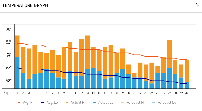
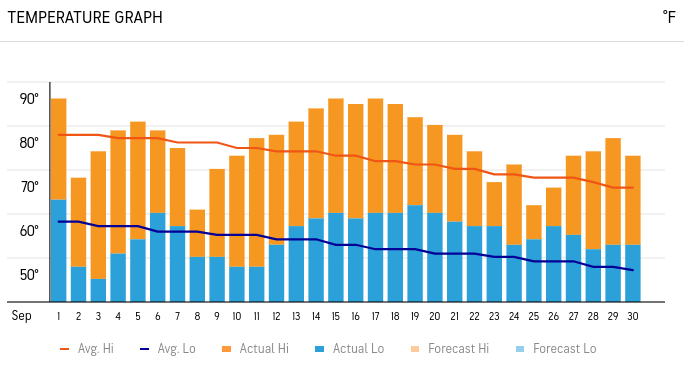
September played out nearly as expected depending on where you are in New England. We predicted a generally seasonable month with more days skewing below average than above. Places like Boston saw more below average days than above with plenty around average. Places like Burlington saw more above average days thanks to a persistent warm-up in the middle of the month, away from the cool ocean influence.
Generally, the pattern progressed a bit quicker than anticipated as we called for a potential warm-up at the end of the month. This came more in the middle of the month. The end of the month did not see a warm-up due to a persistent onshore flow keeping the coastal plain cooler. Areas well inland did see another warm-up. That onshore flow is one of the many small-scale factors that come into play that can't be predicted weeks ahead.
Daily observed temperatures for Boston (1st image) and Burlington (2nd image). The bars show the observed temperature while the lines show seasonal averages:


Commentaires