New England July Weather Outlook: Warm and Wet
- Tim Dennis
- Jul 2, 2023
- 4 min read
After a cool, cloudy and (at times) Rainy June, it's time to turn the page to a new month. While some parts of June's weather pattern will carry over into July, it won't be a repeat. Here's the breakdown of what to expect.

TEMPERATURES
After a fairly cool June for much of New England, temperatures have started to rebound back to seasonable levels. July will be starting off average, but a ridge of high pressure looks to move into the region in the middle of this week, around July 5th. This will allow temperatures to soar amid a mainly clear sky. Temperatures look to be the warmest on Thursday (July 6), when widespread upper 80s will be possible across New England. Humidity will remain elevated, so heat index values may be even warmer.
This ridge of high pressure looks to persist through Friday (July 7), keeping the hot temperatures around. This ridge of high pressure does look to be fairly temporary as the overall pattern New England has been in over the past few weeks will remain in place during this time. At the end of the week (July 7-8), a cold front associated with an area of low pressure will likely move through the region, bringing more clouds and lower temperatures.

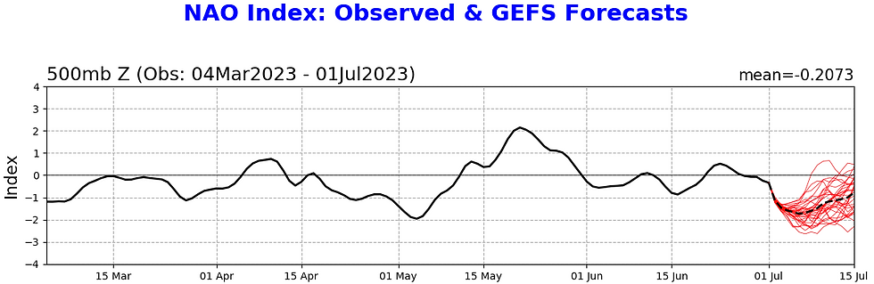
This, along with North Atlantic Oscillation (NAO), point toward the overall trough-dominated pattern continuing. While this pattern doesn't automatically mean temperatures will be cool, it does point to big-time warm-ups being short lived. This can be seen with the upcoming week: it's going to heat up...for three days, before temperatures come back down to average or slightly below average. This means heat waves in July will likely be limited, like they were in June.
To support this, the NAO Index is once again taking a nosedive into negative territory. The Index looks to stay negative through at least mid-July (and could very well stay negative into late-July). A negative phase of NAO supports more troughing in the east. Again, this doesn't mean the whole month will be cool, but that full summer heat will be short lived, and more average temperatures (low 80s) will likely dominate.
A wild card in the temperature forecast is where exactly low pressure systems set up in the northeast. In a trough, these systems will continue to come through (more on that in the rain section below). Temperatures will be coolest around the center of these systems, and right now it appears that will occur more in the Mid-Atlantic.
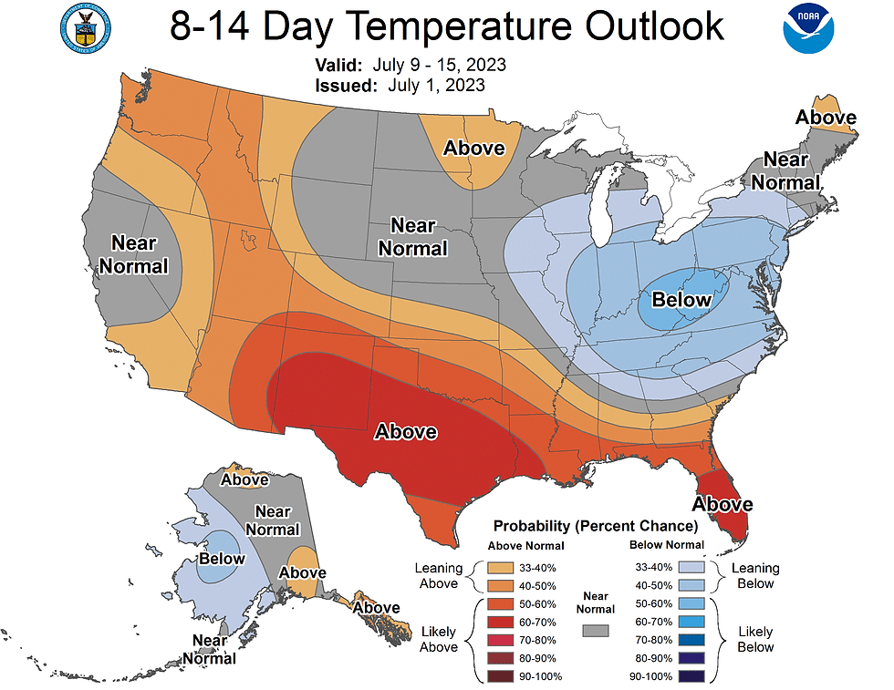
This can be seen on the 8-14 day temperature outlook, with a better chance of lower than average temperatures to our southwest. Overall, there will generally be a higher chance of above average temperatures in northern New England, similar to June.
July's set up will also lend itself to continued high and very persistent humidity thanks to a continued southerly flow. This humidity will likely continue to lead to above average overnight lows. This high humidity will also help aid in keeping the daytime warm amid clouds and unsettled weather. There are signals of a warmer second half of the month, but this will hinge on blocking in the North Atlantic breaking down.
RAIN
A negative NAO and continued blocking will lead to unsettled weather persisting into the month. Despite the Omega Block (that held steady for much of the month) breaking down, a ridge of high pressure in the North Atlantic will continue to lead to blocking in the northeast. This block creates a trough over the region, which makes it difficult for low pressure systems to exit. This, in turn, leads to these systems sitting around New England for days on end.

After the ridge of high pressure moves offshore of New England late this week, a cold front will move very slowly over the region and may even stall. This will lead to cloudy, rainy and overall unsettled weather to return. This will continue to be the case for New England until that blocking high in the North Atlantic breaks down. On June 29, New England Storm Center summed up this pattern by saying:
"New England's weather pattern can be summed up in one sentence: slow moving cutoff lows bringing showers and storms for days on end with brief ridging in between allowing drier weather."
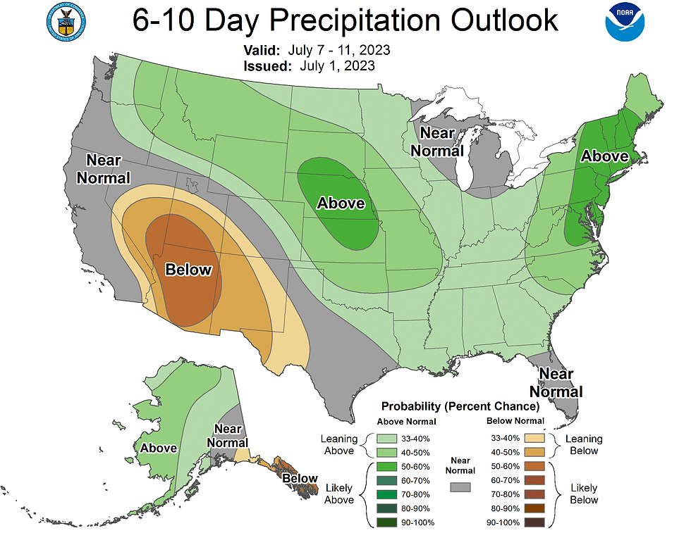
All of this supported by the Climate Prediction Center's precipitation outlooks. All of the outlooks (6-10 day, 8-14 day, 3-4 week and monthly) favor above average precipitation for not only the northeast, but much of the United States.
This doesn't mean the entire month will be washed out. In June, there were many dry hours most days with scattered downpours cropping up. This is how the pattern will continue to play out. Overall, there should be many more dry hours than wet hours, but rain and thunderstorm chances will stick around most days...at least until a major pattern change occurs. When that will happen is still up in the air, but it's certainly possible for the second half of the month.
In early June, a small area of drought developed in northern Vermont. Thanks to this unsettled pattern, it is basically a certainty that this drought status will be removed at some point this month.
LOOKING BACK
While no monthly outlook can truly be a slam dunk, June 2023 was about as close to that as it gets. Right from the get-go of June, it was pretty clear that it would be cooler, and that's how it was. Our outlook did lean toward more of a "ridge-in-the-west; trough-in-the-east" pattern instead of what actually set up, which was an Omega Block. This caused the west to stay cooler, like the east while the country's midsection baked. Regardless, both of these patterns give New England the same result: cooler and more unsettled weather.
留言