We are now officially into meteorological winter (December 1-February 28). Average temperatures continue their tumble, but the rate of the tumble does begin to slow. November sees average highs drop 10-12° while December sees averages drop 7-9° from the 1st to the 31st.
Summary: While fall was mild from start to end, things are changing heading into meteorological winter, with a below average December temperature-wise expected. The first half of December is looking very cold, but this may change heading into the second half. Near average precipitation is expected. Read below for all the details.

TEMPERATURES
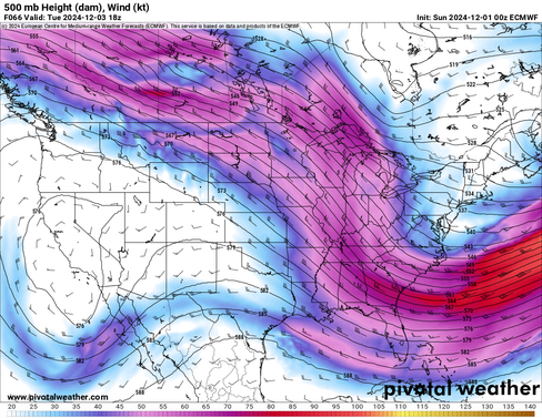
For the start of December, the United States will be in a distinct ridge-in-the-west-trough-in-the-east pattern. This is a major flip from what was experienced during much of the fall, when persistent and prolonged ridging had a hold over New England. This consistent troughing to start the month will bring persistent chill. Multiple disturbances will rotate through the trough, bringing reinforcing shots of polar air to New England. This will allow December to start off with winter temperatures.

Heading toward the end of week one (December 5-6), an Alberta Clipper system will dive through New England, bringing a round of snowfall and a cold front. Strong cold air advection will occur behind this system, allowing for the first Arctic air mass of the season to infiltrate New England. Next weekend will likely be the coldest of this stretch, with highs topping out no higher than the 20s for most.
Below: 850mb (about 4,700 feet above sea level) temperatures next Friday, showing the very cold air mass filtering into New England after the passage of the late week system (the Alberta Clipper, which can be seen just to the northeast of Maine on the map):

These persistently chilly temperatures look to persist into the start of week two (December 8-9). After that, the overall pattern does look to begin to slowly evolve through the rest of the month. The pattern to start off December is an amplified one, which is when the jet stream takes on a wavier pattern, where the motion is more north to south rather than west to east. This creates large ridges and troughs in the jet stream, and in this case, the east will be in the trough.
Heading toward the middle of the month, the large-scale ridge in the west is generally expected to remain in place. With that said, the upper-level pattern is currently favored to begin to de-amplify during this time. This would set up a more zonal flow, which is when the jet stream takes on a more west to east pattern, leading to less pronounced ridges and troughs. This would, in turn, allow the general troughing in the east to begin to weaken in the middle of the month. This could support temperatures rebounding from being persistently below average.
Below: Flow at the 500mb (jet stream) level on December 3rd (1st image) and December 13th (2nd image). The second image shows a much less amplified (zonal) flow across the United States compared to the first image:
It should be noted that the jet stream and upper-level flow is constantly in motion. While troughing may dominate for the first half of December, it won't necessarily be present all the time. For example, late next week the current troughing will break down to more zonal flow for New England, which is when the Alberta Clipper will come through, before a trough digs back in next weekend.
Heading into the second half of the month, the gradual evolution of the pattern is looking to continue. That is to say that the west may shift more toward neutral heights (neither strong ridging nor troughing) while the east sees a gradual transition to above average heights (ridging). This may lead to a warmer second half of December relative to averages compared to the first half of the month.
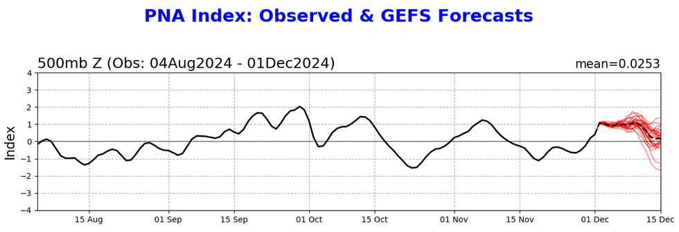
Below: NAO and PNA index values through the first half of December. You can see PNA values dropping to near neutral while NAO values begin to rise. This is an indication of the steadily evolving pattern through the month:
The second half of December is looking to run more mild than the first half relative to average (which again drop several degrees from the beginning to the end). The question is to what degree. The other question will be how frequently cold air intrusions happen in the second half of the month. Should these be able to develop frequently, it would temper any potential more prolonged warm-up.
Overall, we're predicting a below average December temperature-wise for New England, driven largely by persistent cold at the start of the month. At this point, any potential warm-up in the second half seems unlikely to cancel out the cold first half. With colder average temperatures at the end of the month, a warm-up back to near average also wouldn't be enough to counter the cold start; it would need to warm well above average, which is not likely at this point.
PRECIPITATION
After a very dry fall, New England has begun to enter into a more active pattern once again. With troughing in place over New England, it could lead to a continuation of the more active pattern. The question will be can organized storm systems manage to develop within the troughing? The answer to that question in the near term is no. While an Alberta Clipper will likely bring some snow to New England later this week, it is the only organized system on the docket for the region.
Overall, there's not really a strong signal either way for above or below average precipitation. Whenever this is the case, it seems best to just go with near average for a prediction. With a drought across much of New England, it will take more than near average precipitation to break the drought and drought conditions are expected to persist through December, barring multiple large-scale storms.
Below: Monthly drought outlook, showing conditions expected to persist through the month in places where a drought already exists in New England:

LOOKING BACK
November played out exactly as expected. We predicted an above average month temperature-wise. All of New England saw above average temperatures as a whole with Caribou and Hartford seeing all-time warmest Novembers. We also mentioned that cold air intrusions would be brief and weak, which is what occurred throughout the month. The region also saw below average precipitation, as expected.


Comments