Moderate Icing Possible in Northern New England
- Tim Dennis
- Mar 28
- 3 min read

The first of two main waves of low pressure to ride along a stalled front over New England will arrive tonight and last through much of Saturday. The most widespread precipitation will fall on the north side of the low pressure system over northern New England. Winter storm warnings have been issued mainly for freezing rain across southwest New Hampshire with higher snowfall likely in northern Vermont. Winter weather advisories have been issued for lighter icing and some snowfall.

Conditions will be cold enough across interior northern New England for snow initially. Overall, the heaviest of the snow may fall within a rather narrow band. As of now, this band looks to extend from northern Vermont through the White Mountains and across western Maine. These areas will have the best chance at seeing 3-6 inches of snow, with some higher amounts likely.

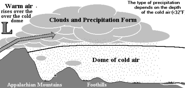
An impressive warm nose will work into northern New England aloft. This will come as surface features keep colder air trapped at the surface, leading to cold air damming. This will bring a period of mixed precipitation and icing to portions of northern New England. This zone of mixing looks like it will set up over southern Vermont and New Hampshire as well as southwest Maine. Eventually, (likely by Saturday afternoon or evening), the warmer air aloft will win out and move farther north in New England. A deeper layer of warm air over shallower cold air is indicative of freezing rain.
Below: Diagram of cold air damming:
Areas that see primarily freezing rain Saturday into Sunday (this zone will be moving around throughout the weekend) could see upwards of 0.20-0.50 inches of total accretion by Sunday evening, with locally higher amounts possible. Current trends have this area most likely to set up over central Vermont into southern New Hampshire away from the coastal plain.

These areas will likely see an elevated power outage threat. It takes about a quarter inch of ice to begin to create isolated problems. Getting into the half inch area will begin to create more widespread issues. A wide portion of northern New England may see at least a tenth of an inch.
Northern New England’s coastal plain will see plain rain, or a mix of wintry precipitation and plain rain, likely significantly cutting into potential icing totals. Waves of mixed precipitation will likely continue through much of Sunday as the rain/mix line pushes north. For southern New England, some freezing rain/drizzle will be possible Saturday night as the temperature drops.
With that said, this is not a slam dunk ice storm forecast (if such a thing really exists). While the warm nose will be impressive, the layer of sub-freezing air is currently being shown to be a few thousand feet. This means the cold air layer may be just deep enough to support more by way of sleet rather than freezing rain, or at least sleet mixing with the freezing rain, cutting into icing totals.

Also, the freezing rain could be more transitional as opposed to dominant. This would mean a shorter period of freezing rain with more by way of snow/sleet to the north and plain rain to the south. If freezing rain is dominant, that would mean a much longer time would be spent with icing.
The stalled boundary will not be completely stagnant throughout Saturday and Sunday. It will be wavering back and forth. This will allow the rain/snow/mix zones to waver north and south as well. The greatest chances for freezing rain will be Saturday morning, Saturday evening and Sunday from south to north.
Below: HRRR showing potential weather early Saturday morning through early Sunday afternoon:


Comments