Messy Storm Incoming to New England: Impacts, Timing
- Tim Dennis
- Feb 15
- 8 min read
New England's weekend storm will involve an area of low pressure that will lift northward from the Ohio Valley to the north and west of New England. A secondary low pressure system will form and track near New England's coastline. Overall, trends have been toward a later developing secondary low and a stronger primary low. This continues to support mixing taking over the snow from south to north Sunday morning. The northern tier will still likely see mostly snow, though sleet may mix in during the afternoon.

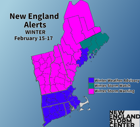
ALERTS


TIMING
There haven't been any major changes regarding timing for this long-duration storm. An initial burst of snow will enter into western New England by late-afternoon. This snow will gradually push eastward through the evening hours. By around midnight, much of New England outside of Maine will be seeing light to moderate snowfall. This initial burst of snowfall will largely miss Maine outside of far western areas. This will play a role in lower snow totals for the Midcoast and points eastward along the coastal plain.
The warm nose of air aloft will already begin to poke into southernmost New England shortly after midnight. This warm nose will continue to slowly push northward through the early morning hours Sunday. We specifically mentioned yesterday that trends would likely slow down this push of milder air, and that's exactly what happened with overnight guidance. By sunrise, the mix-snow line may be draped across either central or northern Massachusetts.
Below: HRRR showing potential hourly weather from this evening through sunrise Sunday:

With a continued trend toward a stronger primary low and a later developing secondary low, this has caused the mixing line to be pushed farther north during the day on Sunday than it was looking 24-36 hours ago. This comes as the primary low, tracking to New England's west, will create a southerly flow aloft, bringing warmer air into the picture. The developing coastal low will maintain a northeasterly flow at the surface, keeping surface temperatures colder.
Throughout the day Sunday, the mix-snow line will continue to push northward, likely well into northern New England. The line will likely reach southern Vermont and New Hampshire by mid-morning. By mid-afternoon, this line may be able to push all the way to the White and across much of Vermont. Maine's coastal plain will also likely be making the switch from snow to a mix by this point.
For southern New England, a changeover from a mix to plain rain will be likely during the afternoon, but the pace at which this happens may be slow. Interior southern New England could see mixing for much of the day. With that said, a dry slot may work into southern areas in the afternoon, reducing precipitation rates greatly. Another batch of more widespread and steady precipitation will likely move through later in the afternoon and into the evening.
Below: HRRR showing potential hourly weather from sunrise Sunday through Sunday evening:

This long duration storm will begin to wind down through the evening hours. By the late evening hours, light and scattered precipitation may hang around, especially across the mountains and northern Maine. A strong cold front will drive through New England Sunday night, which will really start to dry things out (as well as drop the temperatures).
SNOWFALL
For total snowfall, it's rather simple at face value. Amounts will gradually increase from south to north across New England as the mixing line gradually lifts north. As the storm intensifies, snowfall rates will increase across the north while mixing is ongoing across the south. The initial batch of snow (Saturday evening through sunrise Sunday) Likely won't be overly intense. There will likely be moderate snowfall rates, but heavier rates (>1" an hour) are unlikely.
As the secondary low forms and strengthens in the Gulf of Maine, it will begin to create higher snowfall rates for interior northern New England through the day on Sunday. Probabilities for an inch an hour (or higher) snowfall rates become higher Sunday afternoon. For southern and central New England (including much of Vermont), mixing will already be well underway. For areas farther north still seeing snow (mainly interior Maine and northern New Hampshire), this will result in rapid accumulations.
Below: Probability of at least an inch an hour snowfall rates early Sunday afternoon:

Overall, 8-12 inches still looks likely across the north at this time with 2-6 inches across southern New England and Maine’s coastal plain. A band of 4-8 inches is likely in between southern New England and the northern tier (northern MA, southern NH & VT). Northern Maine’s jackpot zone appears poised to deliver over a foot of snow. The main question for central New England (northern MA, southern NH & VT) will be how quickly the mix line arrives and how prevalent is the mixing versus snowfall.
With central and eastern Maine missing the initial burst of snowfall Saturday night and a changeover expected Sunday morning to early afternoon, it will keep totals on the lighter side for much of Maine's coastal plain. With a slower arrival of a change to mix across northern Massachusetts and southern New Hampshire, we dropped our 5-8" zone farther south a bit. Other than that, only minor tweaks were made to our snowfall map from yesterday evening's update.

Some guidance does push for a wider 8-12" zone extending farther south, but with general trends pointing toward a stronger primary low with a stronger push of milder air and mixing pushing farther north, we're hesitant to extend this zone. We're thinking that the high end of the 5-8" zone will suffice to cover this potential rather than going for a low end 8-12" zone.
Current probability of seeing at least 8 inches of snow:

The main reservations about southern New England totals will be the fact that the front end thump of snow will not be overly intense. Snowfall during much of this time may feature very small flakes, similar to last weekend's storm. The nature of these flakes has led to snowfall coming in on the lower end of ranges or under-performing entirely across southern New England in the past couple snow events.
Snow ratios will start off high with a light and fluffy snow. As the event progresses, snow ratios will drop, likely into the single digits for most. This will result in a heavier and wetter snow as the event goes on. This snow is also more difficult to accumulate quickly. Snow ratios will remain higher across central and northern Maine. This will aid in high snow totals overall.
BUST POTENTIAL
Bust potential will be moderate with this one. Some areas of New England face a higher bust potential than others. The main way the storm could bust will be with a faster intrusion of mild air causing a quick transition to mixing. Should this happen, snow amounts will be lower as more sleet falls, which is much more difficult to accumulate. This would occur with a strong primary low and a very late developing secondary low off the coast. Should the opposite occur, snowfall amounts will be increased.
ICING/SLEET
With a strong warm nose aloft riding over a cold air dome, conditions will be primed for a period of icing and mixed precipitation. As stated before, trends have been heading toward a more prevalent intrusion of warm air. This should allow the mix-snow line to push well into northern New England, though it may take much of the day to get there in some areas.

For southern New England, the changeover will occur from south to north and will initially be a period of sleet followed by freezing rain. Much of southern New England may be able to switch to plain rain in the afternoon, but this will depend on the cold air at the surface getting scoured out, which will take time. The higher terrain (Berkshires, Worcester Hills) will likely spend longer with a mix while lower elevations will flip to plain rain more quickly. A dry slot may impact this timing in the afternoon, when precipitation rates become lighter.
For northern New England, the depth of the warm nose will come into play. Southern New Hampshire, Vermont and Maine's coastal plain may see a deeper layer of warmer air develop with a layer of cold air getting trapped at the surface. This would support more by way of freezing rain. Farther north, the warm layer likely won't be as deep, resulting more by way of sleet. The timing and depth of the warm nose will need to be watched in real-time for exact precipitation types and timing in specific locations.

A strip of widespread and more prolonged freezing rain will be difficult to pinpoint, but this zone will set up somewhere in New England, likely just to the west of a coastal front. A very specific setup is needed for freezing rain and just a degree difference could be the difference between mostly sleet and mostly plain rain. Areas just north of this zone will see sleet and areas just to the east of the coastal front will be plain rain.
Up to a quarter inch will be possible where freezing rain is the most prevalent. The amount expected is unlikely to be enough to cause widespread tree/infrastructure impacts, but it will be noticeable in some places. With that said, the combination of light icing, some heavy snow, gusty winds and little to no melting, scattered power outages will be possible.

Below: HRRR showing potential hourly surface temperatures from Saturday evening through Sunday afternoon. The thin red line represents the freezing mark and the potential coastal front:

The speed and northern extent of the warm air aloft will play a large role in total accumulations of ice, sleet and snow. Where temperatures are marginal, both aloft and at the surface, will be the most difficult to determine precipitation types and changeover times. This looks to be the case over much of Vermont, where temperatures aloft will likely be right around freezing or just above by Sunday afternoon.
Below: Euro showing potential temperatures around 4,700 feet above sea level Sunday evening. The dark blue represents the freezing mark (32°). You can see marginal temperatures across the spine of the Green Mountains, plenty of above freezing air across southern and central New England and a rapid drop for northern New Hampshire and Maine:

WIND
The strengthening storm system to the west of New England will likely create a period of strong winds for Vermont and possibly the Berkshires on Sunday. Wind gusts on Sunday may reach the 40-50mph range during the day for the spine of the Green Mountains. A wind advisory has been posted for this area along with a high wind warning for Rutland County, where winds could gust to 60mph due to favorable easterly downsloping conditions.
Below: Potential wind gusts Sunday afternoon, showing elevated conditions across the higher terrain of Vermont and New Hampshire:

Winds will really begin to crank for the entire region Sunday night as the storm system begins to pull away. With a moderately strong low-level jet and strong cold air advection occurring on Monday, widespread gusts of 40+mph will be possible. This will likely be most prevalent during the daylight hours Monday. A high wind watch has been issued for southern New England. The low-level jet will be strongest across southern New England, leading to higher wind gust potential there than in northern New England.
The main question on wind gusts will be if the maximum wind gusts can mix down to the surface. The atmosphere appears well-mixed, supporting gusts of at least 40-50mph. Whether or not full mixing is achieved remains a question. This would result in gusts of 50-60+mph. As of now, odds favor the former solution with high wind watches downgraded to wind advisories for most. The Berkshires and Worcester Hills will have the best chance to see alerts upgraded to a high wind warning. The trends will need to be watched closely and the wind threat could increase or decrease over the next 24 hours.
Below: Potential winds around 4,700 feet above sea level. You can see the strongest will generally be over Massachusetts. How much of this mixes to the ground is the question:

AFTER THE STORM
Much of next week will be cold and windy. It will feel like the depths of January rather than mid-February. New England's next storm to watch will likely come around Thursday of next week. This could be a significant snowstorm for a portion of New England IF the track is right. The incoming cold will play a role in the track. As of now, trends have been suppressing it to the south, but it's certainly close enough to continue watching very closely. Southern New England will have the best chance to see higher impacts from this one.
Below: Current likelihood of impactful winter weather next Thursday:

Comments