A major winter storm is on the final approach to New England. This dynamic, complex storm will bring heavy snow, with accumulations up to a foot in places, as well as the potential for an ice storm in other places. Here's the very latest on all the impacts that are on the way.
ALERTS

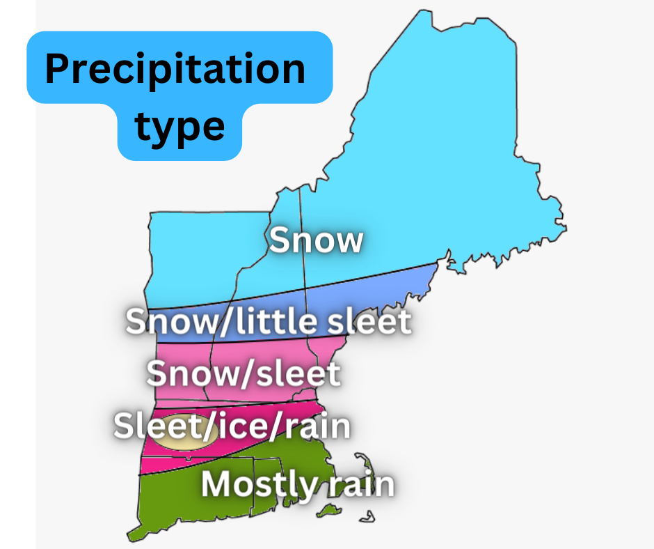
SNOW AND SLEET

The jackpot for snow will be across northern New Hampshire, Vermont and western Maine, where up to a foot is possible. There could be isolated amounts over a foot in the White Mountains. This is where the atmosphere will be below freezing from cloud to ground. The warm air layer is unlikely to get into the areas where a winter storm warning is in place. Up to 2 inch an hour rates are possible early Thursday morning.
Across central and southern New Hampshire, southern Vermont and northern Massachusetts, a shallow layer of warm air is expected aloft. When this happens, sleet will mix in with the snow. This will keep total amounts lower across these areas. In these areas, sleet could become the dominant precipitation type, with a few inches of straight sleet possible. The National Weather Service of Gray, Maine states:
"For southern NH up into far southern ME, sleet is expected to be the primary impactful precip type. Hires models as well as global models indicate enough warming aloft to bring temps at or around freezing...but lock in excellent cold air at the surface. With impressive dynamics remaining here, intensity will be greatest during the Thursday morning commute. Hires models also nudge this warm nose into the ME Lakes region to the coast, thus have trended for less snow and more sleet into Portland and points west.
Lesser amounts of snow and sleet are expected across Massachusetts as warmer air will lead to mostly ice, sleet and plain rain. Still, a couple inches of snow and sleet is possible in these areas.
ICE

While the warm air layer is expected to be more shallow across central New England, southern New England will likely see a deeper layer of warm air aloft with temperatures below freezing. Unfortunately, this is a prime set up for a potential ice storm. Up to a quarter of an inch of ice is now expected across western and central Massachusetts with up to a tenth of an inch possible across southern and possibly even central New England.
The winter weather advisory for southern New England states:
"Power outages and tree damage are likely due to the ice. Travel could be nearly impossible. The hazardous conditions could impact the morning or evening commute."
New England Storm Center has been warning about a potential ice storm in these areas since Saturday, and it is now looking likely. While I'm not ready to say a significant ice storm is on the way (which I consider to be a half inch of ice), a quarter inch of ice is going to cause some problems, as seen in the winter weather advisory.
Some areas of Massachusetts will rise above freezing at the surface, which will switch the freezing rain over to plain rain. How long it takes for this to happen will determine how much ice accumulates. There are some discrepancies in total ice, with some outlets pointing to a significant ice storm while others barely even mention ice. While it is more likely that a significant storm will occur, I will have a close eye on western and central Massachusetts.
There is a lower risk of ice accumulation across southern Vermont and southern New Hampshire. As stated before, the warm air layer is expected to get that far north, but it will likely be more shallow, leading to sleet. However, if the layer becomes deeper, the sleet could mix with freezing rain, leading to some ice accumulations.
RAIN
While much of New England will be below freezing at the surface, most of Connecticut, Rhode Island and the south shore of Massachusetts will likely warm above freezing, leading to plain rain in these areas. A quarter to a half an inch could fall, with the peak of the rain coming in the early morning hours.
TIMING
This evening: Snow, mix, rain breaks out across southern New England and southern Vermont.
Wednesday night: Storm spreads into Vermont and New Hampshire, snow and ice likely in Massachusetts, snow and sleet across northern New England. Rain falling in eastern Massachusetts.
Around midnight: Bulk of the storm begins. Heavy snow falling in northern New England, mix and ice falling in southern New England. Maine gets into the snow.
Thursday morning: Heavy snow continues in northern New England. Mixing pushes into southern Vermont and New Hampshire.
Around noon: Storm begins to wind down across the region.
Thursday afternoon: Scattered light snow/sleet/ice showers.
Thursday evening: Precipitation picks back up, light additional accumulations possible.
Thursday night: Second wave of storm winds down slowly overnight.
Comments