It's a bit of deja-vu as last Thursday, we published an article with this same title (minus the again, of course). We're watching another storm set to come through New England Sunday night and into Monday. There are some similarities and some differences with this storm versus last week's. Overall, this storm doesn't look to be quite as potent as last week's.
There will likely be a surge of mild air from the south ahead of the system, leading to another mild rainstorm for much of New England. The storm, that was once looking to track along the coast, is now looking to track well inland. This would further support a rainstorm for all of New England. The storm is once again looking to be Sunday night through Monday.

Being several days out, there is still room for a wiggle in the track. At this time last week, it looked like Vermont would see a soaking rainstorm the entire time before an eastward shift in guidance brought more snow into the picture. Whether or not snow will fall will also hinge on how much this system phases with a clipper system to New England's north.
What the Euro, GFS and CMC are showing for Monday morning:


With that said, models have been trending more westward rather than eastward, but we'll need to continue watching the trends. Colder air won't be too far away from northern New England, either. That is to say, interior snowfall during this storm is not completely out of the question just yet. As usual, once the cold front comes through New England, some snow showers will be possible on the backside of the storm no matter the track. This would likely be Monday night into Tuesday.
Similar to last week's storm, this storm will have an excess of moisture to work with as the system will dive into the warm Gulf of Mexico and carry that moisture up the east coast. This will once again allow for potentially heavy rainfall rates, more typical of warmer months rather than the winter ones.
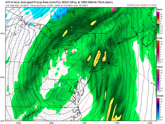
GFS showing the storm comlex lift out of the Gulf of Mexico and up the east coast:

Where the heaviest rain falls will be determined by the exact track, but it is once again looking to be more in eastern areas of New England rather than western areas. With the potentially heavy rainfall rates, another widespread 1-2 inches of rain is possible across New England. The Weather Prediction Center currently has all of New England minus Vermont and northern New Hanpshire in the "marginal" category for excessive rainfall.
NBM rainfall forecast:

There will be a chance for some gusty winds with this storm along the coast. Last week's storm featured southerly winds. This storm's winds may be more southwest in nature. Strong southerly winds aloft have a tougher time reaching the surface as strong southwesterly winds. With that said, signals at this time for strong winds with this storm aren't as strong as they were at this time last week for last week's storm.
Finally, there is a potential coastal flood threat with this storm with potentially strong southwesterly winds. As always, the coastal flood threat will come down to timing, if the strongest winds line up with high tide. The coastal flood threat will become much more clear in the next 24-36 hours.
After this storm passes, blocking that is expected to set up over the Atlantic may make it difficult for the storm system to make a timely exit. This would keep New England in a trough and allow unsettled weather (rain/snow showers) to continue through the middle of next week. Looking at temperatures, there are no signals for any strong cold shots anywhere in the country as arcitc air remains generally bottled up well to the north.

Comments