Extreme Arctic Blast Grips New England
- Tim Dennis
- Feb 2, 2023
- 3 min read
Updated: Feb 4, 2023
Live coverage of this event has ended
2/4 11:44am: Temperatures will continue to rise for the most part from now until Sunday afternoon. It will remain VERY COLD throughout the day today.

2/4 10:18am: Route 1 in Maine from Caribou/Conner line to Van Buren is CLOSED due to road conditions. A ground blizzard is occurring in northern Maine.
2/4 9:10am: Mt. Washington and Boston hit long standing records.
Mt. Washington wind chill hit -108°, which is likely the coldest ever in the United States (there is no official record kept for wind chills).
Boston's air temperature hit a low -10° overnight, this is the coldest low temperature in the city in 66 years.
2/4 8:10am: Wind chills this morning range from the -20s to near -50 across New England. Winds will very slowly die down as today goes on.

2/3 11:10pm: Temperatures have stalled out over the last couple hours. Dangerous win chills remain ongoing and will continue all night long and into Saturday. This arctic blast has just about reached historic levels. NWS offices of Gray, Maine states:
"Forecast still on track for the most part. Temps have flat lined a bit, as we are getting close to fully mixed. We are still a few degrees off mins, so seems reasonable we could get there, with a little push of colder air. Still, this will not change anything regarding wind chills or the dangers of being outside overnight."
The NWS of Boston states:
"This is a historic arctic outbreak for the modern era. We expect Boston to bottom out between 8 and 10 below zero and Worcester in the 14 to 16 below zero range. FWIW...Boston reached -9 in 2016. That is the coldest temp observed in the city since 1957. If Boston were to reach -10 it would be the first time the city experienced double digit below zero readings since dropping to -12 in 1957."
2/3 10:56pm: New England is currently seeing varied, scattered power outages.
A couple hours ago, there were nearly 70,000 outages with over 42,000 in Massachusetts alone. As of 11pm, there are 32,823 outages, with Massachusetts sitting at 12,664. Outages will likely continue to fluctuate all night long.
2/3 9:10pm: Reports of trees "exploding" are coming in from New Hampshire and Maine. This happens when the sap inside the tree freezes, causing the trees to shatter.
2/3 8:08pm: Wind chills currently in the -10s to -20s in southern New England and the -30s to -50s in northern New England. Frost quakes are also being reported across the region.

2/3 6:52pm: -100 has been achieved.

2/3 6:40pm: There are just over 27,000 customers without power across New England as the entire region falls below zero with much lower wind chills.
2/3 5:10pm: Strong winds are creating scattered power outages across the region. This is concerning as wind chills will be dipping well below zero tonight. DO NOT RUN GENERATORS INDOORS.
2/3 11:40am: Wind chills below zero region wide and well below zero across all of northern New England. Plummeting temps will likely slow in the afternoon before plummeting again in the evening to overnight hours.

2/3 10:46am: A tree crashed down over a road in Salem, New Hampshire and struck two cars, one person seriously injured. This knocked out power to a small number of people amid the arctic blast. Currently just over 5,000 customers across New England are without power as gusty winds accompany the extreme cold.

WMUR
2/3 10:01am: Ski resorts across New England are scaling back operations for today and tomorrow, including the major resorts of Killington, Sunday River, Sugarloaf and and Bretton Woods. Jay Peak in Vermont has closed entirely today.
2/3 9:39am: Wind chills have already fallen below -30° in areas of northern New England. Boston approaching 0°

2/3 8:44am: The National Weather Service is calling this "near historical" this morning as temperatures continue their plummet. The Gray, Maine office states:
"A near historical cold air outbreak is moving into the region this morning. While this event is forecast to be significant with respect to ambient surface temperatures, long- standing benchmarks concerning apparent temperatures (wind chills) and the air mass itself will be challenged...If wind chills fall to -40 or -50F this will be the first time in 20 or 30 years for many locations."
2/3 7:38am: The arctic front is approaching southern New England; schools across New England, including Boston Public Schools, are closed today

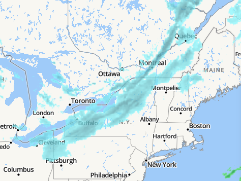
2/2 11:08pm: A line of snow squalls is beginning to enter New England. A snow squall warning is currently in effect for northwest Vermont. This line of squalls will likely hold together through much of northern New England, movement of this line will be similar to a line of thunderstorms.

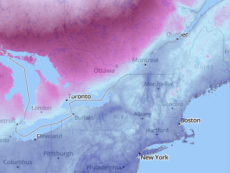
2/2 10:00pm: The arctic front is approaching New England as seen by a line of snow squalls on radar. The temperature chart on the right shows where the arctic air is. The air is quickly dropping down from the northwest into New England and New York.


You've reached the beginning of this event's live updates
Comments