A frontal system will bring a period of light rain and snow showers to New England later Saturday into Sunday morning. Light accumulations of both rain and snow are likely. The system's cold front will be quickly followed by an Arctic front, which will slow down as it reaches New England's coastline for Sunday into Sunday night.

A wave of low pressure will quickly develop later Sunday along the slowed front and track northeastward near New England. The track of this system will come down to the timing and location of the cold front offshore.

The low pressure system will likely develop rather quickly to the south of New England and gradually strengthen as it rides northeast along the cold front. This will likely be a quick-mover, moving into southern New England Sunday afternoon and evening and exiting Maine by Monday morning. This should be an all-snow event for most with just Cape Cod and the Islands potentially seeing mixing issues.
Below: Euro showing potential weather Sunday evening (1st image) and around sunrise Monday (2nd image):


As of Friday morning, there remains a decent spread in the system's potential track. The easternmost track being depicted (supported by NAM) would bring the storm outside the benchmark, resulting in more minimal accumulations. The westernmost track (supported by RGEM) brings the storm's center over Cape Cod, allowing for more mixing issues near the coast.
With that said, the middle ground between these two outcomes is the most likely, where the system tracks near the benchmark. This would bring a period of snow that would result in plowable accumulations over a good portion of southern New England, southern New Hampshire and Maine's coastal plain. The likelihood of moderate winter storm impacts has increased notably over the last 24 hours.
Below: Probability of winter weather impacts Sunday afternoon into Monday morning:

In the end, the track of the storm will come down to the timing and location of the cold front offshore as the system will be riding along it. This is the main point of contention within guidance, though everything should start to align within the next couple runs.
Given how trends are going, a preliminary estimate of snowfall will likely be around the 3-6 inch range across a wide swath of southern New England, southern New Hampshire and coastal Maine. Amounts will likely steadily drop off moving into interior northern New England, with northern Vermont and northern Maine seeing low probabilities for 2 inches of snow.
Below: Current probability of seeing at least 4 inches of snow:

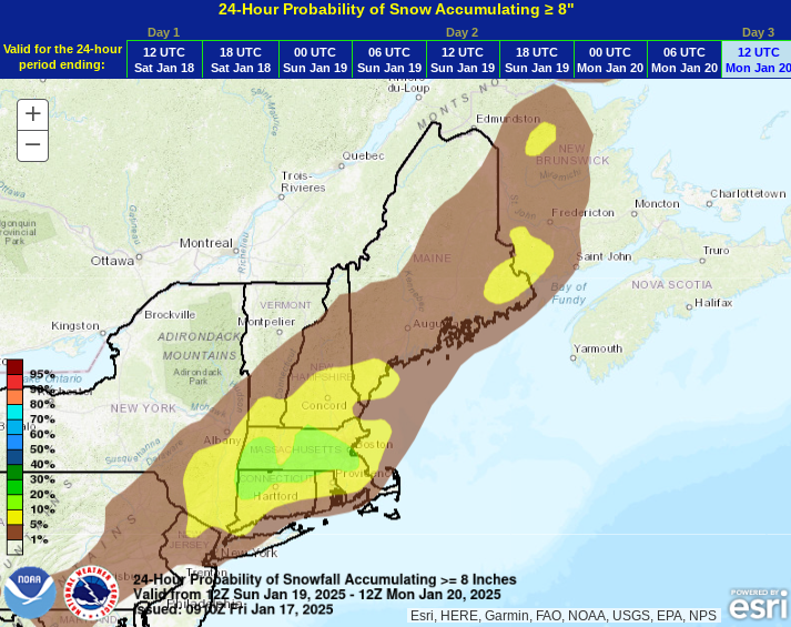
This represents the most likely scenario, however, the farther east solution with less snow can't be completely thrown out quite yet. On the other side, if the storm's track inches a bit farther west, passing just inside the benchmark, that would be the sweet spot for the maximum amount of snow. It wouldn't take much of a westward shift from where guidance seems to be honing in on right now to produce higher amounts. This is represented by low probabilities of at least 8 inches, seen below.
Below: Current probability of seeing at least 8 inches of snow:
The main limiting factor for snowfall will be the storm's quick motion. This is shaping up to be a 12 hour storm system for New England, likely 7pm to 7am, give or take a couple hours on each end. This will help to hold snowfall in check. The main factor working for higher snowfall will be high snow ratios. For most, this will likely be a fluffier and dry snow. This type of snow accumulates quickly as it compresses little on impact with the ground.
As stated before, there remains a decently large range in tracks among ensembles. So, while 3-6 inches seems like a reasonable swath for a wide portion of southern and central New England, there remains a chance of greater than usual adjustments in snowfall over the next 24-36 hours. Trends will continue to be watched closely.
The overall setup of this system is known as anafrontal. When most cold fronts cross New England, they advect cooler and drier air into the region, allowing precipitation chances to diminish (this setup is known as katafrontal). When an anafrontal setup occurs, the cold air rapidly pushes against the warmer air ahead of the front, causing the warmer air to rise over the colder air behind the front, resulting in clouds and precipitation behind the front rather than clearing.

The wave of low pressure will aid in creating precipitation on the cold side of the front over New England. This will help tremendously in making this a mainly snowfall event. Cold air will be crashing into New England behind the front Sunday afternoon and evening. This will come as precipitation blossoms instead of dwindles (as would be the case more often than not).
One last note to make about this storm is that it will be one-dimensional. The storm will bring a period of steady snow, and that's just about it. No heavy rains, no extreme snowfall rates, no wind, no coastal flooding, no sleet/ice and minimal mixing.
ARCTIC BLAST
The Arctic blast of air coming next week will likely peak (or bottom out) early to mid-week. This blast will likely be deep and widespread across the central and eastern United States. For New England, the lowest temperatures appear poised to come in the Tuesday to Wednesday time frame. These days will likely see high temperatures in the single digits north to teens south.
Overnight lows will be in the single digits, on either side of zero. There will be a chance the coldest hollows of northern New England (mountains, Northeast Kingdom and northern Maine) will drop into the -10s. Wind chills will drop below zero during this time region-wide with minimum values potentially reaching for the -15 to -25° range.

As we get closer to this Arctic blast, this is a good time to remind everyone of changes to cold weather alerts that the National Weather Service made coming into this winter. Wind chill advisories have been replaced with cold weather advisories and wind chill warnings have been replaced with extreme cold warnings. Should alerts be needed next week, these new alerts will be used.
BEYOND
Looking at the long term, a southern stream storm system appears poised to develop around early to mid next week near the Gulf of Mexico. This could bring the south another winter storm next week. Where this storm goes from the south is anyone's guess at this point.
Whether or not it hugs the coast and comes up to the northeast or remains well offshore will likely come down to the timing of the Arctic air. Should the Arctic air mass hang around, it would likely stay offshore later next week, but this is trying to look out too far to get into any kind of detail. For what it's worth, Weather Prediction Center odds favor the storm being suppressed south at this very early stage in the forecast.
Below: Weather Prediction Center probability of impactful winter weather around midweek next week:

Comments