On this week's Weather Wednesday (which is returning for 2024) episode, I talk about New England's weekend snowstorm chance as well as continued stormy weather continuing after this storm. I also briefly go over New England's 2023 weather year in review.
Prefer to read? There's a written version below the video. You can also read about New England's 2023 weather year in review here.
There is likely a snowstorm on the way to New England. This will be a “benchmark” storm. We published an article going over the benchmark coming into this winter. Basically, if the storm center passes over the benchmark, it can bring the heaviest snow totals to much of southern and central New England, if the cold air is in place, and there will be cold air in place. A cold front will drop through New England on Thursday. This front will drop temperatures from the 40s, where they’ve been, down to the 30s.
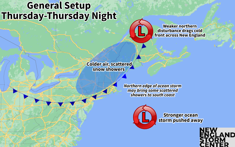
This will allow the storm to be mostly snow, except near the coast, where mixing and rain is possible due to the warmer air over the ocean with ocean temperatures still running in the low to mid 40s. How much (and how intense) the snowfall is remains the big question. Right now, it still looks likely that a jackpot zone of 4-8 inches will be possible somewhere in southern New England. Where this zone sets up will be determined by the exact track.

Yesterday, we laid out three potential outcomes for this storm based on three major models. This morning, the storm has trended a bit further south, to the outside of the benchmark in the GFS, CMC and ICON models. This would lead to lighter snowfall, especially further north. The Euro still has the storm a bit more northerly, near the benchmark, which would lead to higher snowfall totals.

Basically, the further south in New England you go, the higher the chances of seeing more snow with those chances dropping off as you head north. The exception to this would be near the coast, where, as we said before, some mixing and rain is likely, which would naturally keep the snowfall amounts down.
The energy for the storm is elongated, with a secondary area of low pressure near the Great Lakes while the coastal low moves through New England. The storm will also likely keep on moving rather than stalling out. These two factors will prevent this from being a really large snowstorm with 12, 18, 24 plus inch amounts. Most areas will likely stay in the single digits for snowfall with 2, 3 inch an hour rates unlikely.

The overall strength of the storm will, naturally, come into play when figuring out exact amounts. This is still a big uncertainty. The main storm center is still over the Pacific Ocean as of Wednesday morning. Models will continue to vary quite a bit until this energy piece gets into the upper-air pattern over land. I expect a clearer idea of what to expect by Thursday morning. We’ll need to watch the trends closely over the next 24 hours to see just what this storm will have to offer (and where).
After this storm, the stormy times will continue for New England with a potentially potent storm with strong winds and heavy precipitation. The atmosphere does look like it will be primed for heavy rain/snow. With this storm being a week out, there’s plenty of time to watch the trends.
Euro models showing a potential storm midweek next week:

コメント