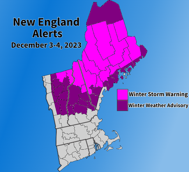
An impactful winter storm is looking to come to parts of northern New England Sunday night into Monday. This storm will feature a "double barrel low" setup with a primary low tracking across northern New England and a secondary, coastal low forming and tracking to the south of New England and north of the benchmark. This setup will bring rain to southern New England and snow to northern New England.

ALERTS
TIMING
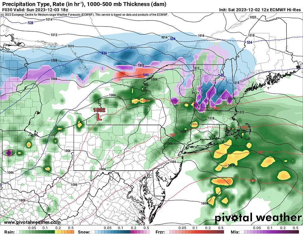
Some rain showers will be possible Sunday morning as a separate disturbance moves through. The storm will enter into the region early Sunday afternoon with rain showers across southern New England, Vermont and southern New Hampshire. Snow showers will be likely across the Green Mountains and New Hampshire lakes region and points north as the afternoon goes on.
Expected weather early Sunday afternoon:
The precipitation will spread generally southwest to northeast through Sunday afternoon and into Sunday evening. By Sunday evening, snow will likely have picked up in intensity in the Green Mountains and much of New Hampshire away from the coast and river valleys. The snow will also likely have spread into Maine by the evening.
The heaviest of the snow and rain will likely occur from Sunday evening through at least the first part of the overnight hours Sunday into Monday. A dry slot may slow precipitation rates in the second half of the night. The most uncertainty in snowfall is across interior Maine toward the Capital region. Just how close to the coast the snow is able to get in Maine is where the biggest question remains. This area would be the most likely to overachieve on the snowfall map below.
What we do know is that southern New England and the New Hampshire seacoast will be all rain while the Green Mountains, White Mountains, New Hampshire foothills and much of Maine away from the coast will be primarily snow. A rain/snow mix will be more likely across southern New Hampshire into the Lakes Region. Generally, the further north you go, the more snow is likely. This will generally be rain, snow or rain/snow mix storm. There will be little sleet and freezing rain.
Expected weather Sunday evening (1st image) and overnight Sunday to Monday (2nd image):


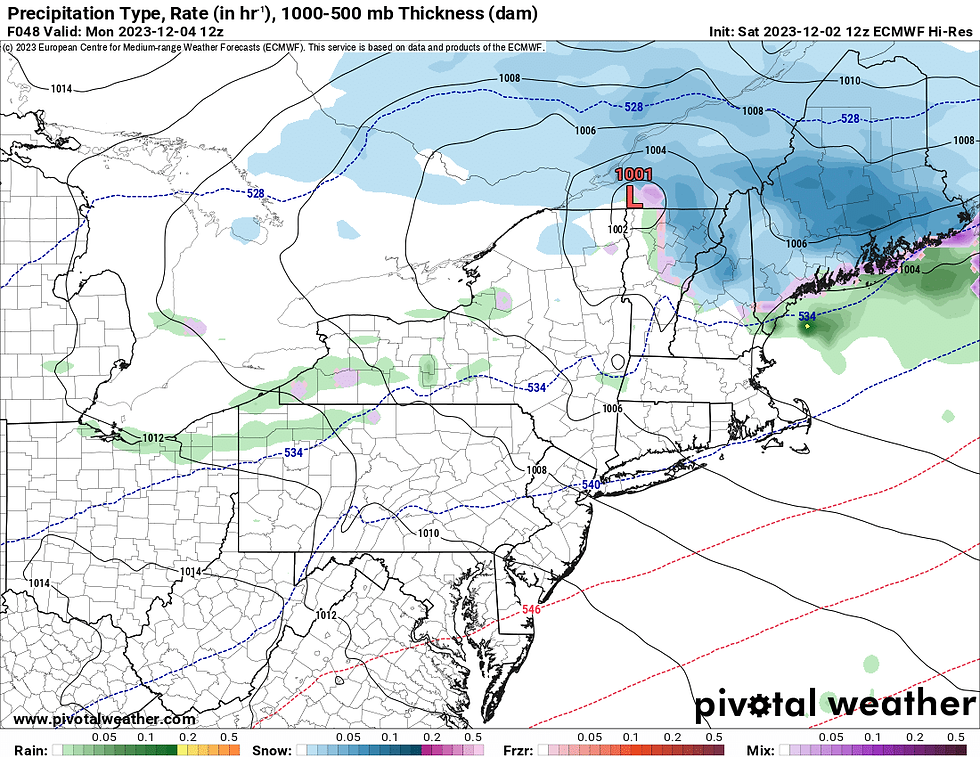
By Monday morning, the coastal low will be racing away toward Nova Scotia, however, the primary northern low will still be working through northern New England. This will lead to continued lighter snow showers across northern New England through the morning while southern New England will likely be drying out by sunrise.
Expected weather Monday around sunrise:
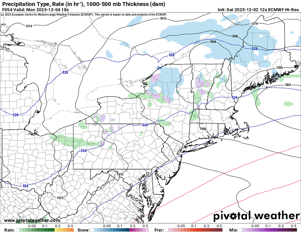
There will very likely be lingering snow showers across northern New England through Monday and into early Tuesday as the main storm continues to pull away and another, much weaker, disturbance pushes through.
Expected weather Monday afternoon:
SNOW
A period of moderate snowfall is expected Sunday evening through Monday morning for the higher terrain and foothills of northern New England. This should allow for several inches of snow across much of northern New England away from the coast.
The most snow is looking to fall across the White Mountains at elevation and the Maine highlands. These areas will stand the best chance at seeing 8 inches or more of snow.
A half foot of snow will be possible at elevation in the Green Mountains (chances for 6 inches in the Greens is mostly likely above 2,500 feet), the White Mountain region below 1,500 feet and central Maine.
Lesser amounts will be seen across the Connecticut River Valley, the Lakes Region and Maine outside of the highlands. These areas will still have the chance to see a few inches of snow, however. A quick coating of snow will be possible across southern Vermont, southern New Hampshire and the Maine coast. These areas will likely see primarily rain. Some quick snow will be possible in these areas at the very tail end of the storm.
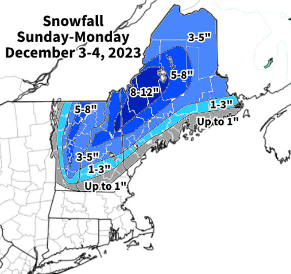
Snow will be elevation dependent to an extent with this storm with valleys coming away with less than the slopes. There are some limiting factors for snowfall including marginally cold temperatures and snow ratio. This will likely be a heavy, wet snow, which is more difficult to accumulate. There could be an aggressive dry slot that shuts snow down earlier as well. These reasons could indicate a potential "bust" with the storm in some areas.
One last thing to consider with this storm is the potential for some power outages. With several inches of a heavier, wet snow, branches could be weighed down, leading to issues. Widespread outages are not expected, but scattered outages are a concern.
RAIN
Southern New England and the northern New England coast will be looking at steady rainfall Sunday evening through Monday morning. The aforementioned aggressive dry slot may eat away at some rain totals, but a widespread half an inch to an inch of rain is possible. Flooding is not a concern.
Comments