Heavy Rain & Winds Incoming to New England: Impacts, Timing
- Tim Dennis
- Dec 10, 2024
- 6 min read
A strengthening cold front will approach New England ahead of a trough over the Great Lakes. A surface low pressure system will likely form along this front to the south of New England and move northward through New England during the day Wednesday. The storm system will be strengthening as it moves through the region. This storm is reminiscent of last December's soaking storms.

ALERTS (as of Tuesday morning)

TIMING
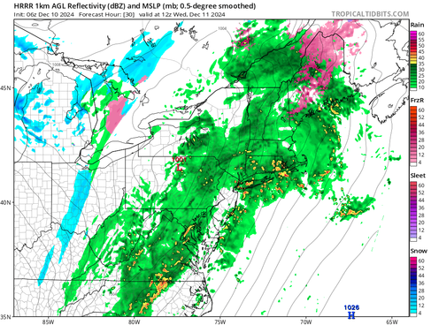
Scattered and light precipitation will begin to move into New England from southwest to northeast this evening. This precipitation will gradually fill in throughout the overnight hours into Wednesday morning. With cold air damming remaining at the surface across the New Hampshire and Maine mountains, this initial precipitation may fall as freezing rain. Everywhere else, this will be plain rainfall.
Below: HRRR showing potential weather around midnight tonight (1st image) and around sunrise Wednesday (2nd image):
By early Wednesday afternoon, widespread rainfall will be ongoing across New England. The cold air dam will likely have eroded away for much of the region as a strong southerly flow picks up. This will allow any freezing rain that was falling across New Hampshire and Maine to switch to plain rain. Steady rain will continue across the region through the afternoon.
Below: HRRR showing potential weather around midday Wednesday:

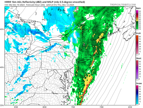
There may be a time in the afternoon where rainfall becomes a bit lighter and even more scattered. This is due to the fact that the heavier precipitation looks to come in two main rounds. The first will be along the warm front as it lifts through New England from the morning through the afternoon while the second round will be associated with the cold front, which will move west to east later Wednesday and into Wednesday night. This is also when the strongest winds will occur.
Below: HRRR showing potential weather mid-afternoon Wednesday (1st image) and Wednesday evening (2nd image):
Once the cold front moves through, precipitation will begin to clear up Wednesday night into Thursday morning. The temperatures will be dropping behind the front and snow showers wrapping into the backside will be possible, mainly across Vermont and western Massachusetts. By midday Thursday, the cold front and storm system will have cleared New England, with just upslope snow shower activity remaining across the mountains.
Below: CMC showing potential weather in the pre-dawn hours Thursday:

RAIN
A deep trough over the Midwest will allow for showers to break out in New England as the disturbance moves northeastward. This will begin warm air advection, which will help create the initial round of precipitation. Moisture will continue to stream up the east coast from the Gulf of Mexico on a strong low-level jet stream ahead of a strengthening cold front and storm system along the cold front. This storm system will take shape in the deep South. Convection will likely form within the precipitation shield.
All of these ingredients will combine to result in a widespread soaking rain event, with periods of heavy rainfall. A general westward trend in the track of the main storm system has continued, which places much of New England in the zone for periods of heavy rainfall. A widespread 1-3 inches of rain is likely across the entire region. Localized higher amounts are possible across the interior.

While much of New England remains in a drought, rainfall rates could become heavy enough to support excessive rainfall across the region. There will be a risk of some urban/flash flooding with a hard (or completely frozen) winter ground, slowing absorption. This rainfall will be beneficial in the long term, especially for southern New England. All of New England except for Cape Cod, the Champlain Valley and the Connecticut panhandle are included in a "slight" risk (level 2 of 4) for excessive rainfall.

In northern New England, the 2-3 inches of rain will combine with a melting snowpack and a frozen ground, leading to runoff issues. The strong southerly flow will create warm temperatures and high dew points (for the time of year). These high dew points will help melt the snow faster. A total melt-out is expected in southern New Hampshire and Maine with a major reduction in the snow pack across the foothills. The deeper snowpack in the mountains is generally expected to remain in place, albeit with some reduction.
In all, melting snow is expected to add an additional 0.5 to 1.5 inches of runoff to the 2-3 inches of rainfall. This will lead to a total runoff 2.5 to 4 inches across the foothills and northern woods. With the mountains holding onto some snow, it will limit the amount of runoff in those areas. With that said, the melting could dislodge river ice, potentially creating ice jam concerns.
Below: Forecast additional runoff from snowmelt:

Before going on, it should be noted that this is NOT expected to be a repeat of the December 18th, 2023 storm that brought significant flooding to Maine and New Hampshire. With drought conditions preceding this storm, rivers are running much lower and have more storage space for this storm. There will be less snowmelt and runoff from the mountains as well.
At this point, major river flooding is unlikely. As of Tuesday morning, several rivers are forecast to reach minor flood stage across the region with additional rivers reaching action stage. Otter Creek in Rutland, Vermont is currently forecast to reach moderate flood stage. The flood watch across western New England is mainly for the threat of some river flooding.
Below: Current river forecast as of Tuesday morning. Yellow indicates action stage, orange indicates minor stage and red indicated moderate stage:

Flood watches may be expanded eastward later today to account for poor drainage flooding (flood watches were expanded across New Hampshire and western Maine while this was being written), but this is a high uncertainty due to the dry fall. The threshold for flash flooding to occur is 1.5-3 inches in three hours and 2.5-3.5 inches in six hours. With 1-3 inches total on the way, the rainfall rates may make flash flooding difficult, but it certainly can't be ruled out.
WIND
A very strong low-level jet will cross eastern New England later Wednesday into Wednesday night. This jet will have winds of 90-100mph at the 850mb level, which is about 4,700 feet above sea level. Naturally, not all of this wind will make it to the surface, but winds this strong at elevation can support gusts of 40-60+mph. A westward trend in the track has increased the wind threat for eastern New England.

The extent of the winds remains a wild card with this storm. While the very powerful low-level jet supports a major wind event, there are major factors working against winds from reaching their full potential at the surface. How quickly this low-level jet organizes is a bit of a question mark. If it organizes too late, much of the region will be spared the worst of the winds as it will have pushed to the east. For this reason, confidence in potentially damaging winds increases the farther east you go, with Maine's Midcoast and Downeast areas with the greatest threat.
Below: Winds at the 850mb level (about 4,700 feet above sea level) Wednesday evening. This is that strong low-level jet. How much of this makes it to the ground remains to be seen:

There will also be a temperature inversion with the cold air dam eroding during the storm. This inversion (which is a layer of warmer air over a layer of colder air at the surface) can act as a barrier, trapping the strongest winds aloft. Just how mild temperatures can get during the storm will play a role in winds. The milder the surface can get, the weaker the inversion will become, allowing for more wind.

Currently, high wind watches stretch for most of the New England coastal plain. It remains to be seen whether these will be upgraded to high wind warnings or downgraded to wind advisories. There's still room for the wind threat to increase further or decrease (should the track of the storm take a last minute shift to the east) over the next 24 hours. Wind advisories will likely be posted for areas farther inland.
ICE/SNOW
While rain will be, by far, the dominant precipitation type, there will be a chance for freezing rain across interior New England at the start of the event. This will come as the cold air dam remains stubbornly in place. This colder air will erode from southwest to northeast as the day goes on Wednesday. Before that happens, up to a tenth of an inch of additional ice is possible. We say "additional" as this will add to the ice from today.
Below: Probability of at least a glaze of ice through Wednesday afternoon:

As colder air filters in on the backside of the system, some snow will be possible across western New England. Snow showers may continue into the day Thursday for the mountains. Amounts will likely be minimal, even at elevation.
Below: Probability of at least an inch of snow by Thursday morning:


Comments