Relief from all this late summer heat is out there for New England. This relief will come as an area of low pressure drags its cold front across the region. This system is currently in the Great Lakes region. More often than not, this system would have crossed New England by now, but, for the most part, systems have been moving very slowly this summer and this one is no exception.

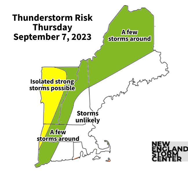
THURSDAY
This heat will peak for most today. Heat advisories are in effect for a large portion of New England as high temperatures shoot toward the mid 80s to low 90s in northern New England and the upper 80s to mid 90s in southern New England. On top of this, dew points will remain in the upper 60s to low 70s for most. This will lead to another afternoon with heat index values well into the 90s and pushing 100 in parts of southern New England.
The leading edge of the relief will make its way into western New England today. Some thunderstorms will likely break out, mainly in areas west of the Connecticut River. Northern New Hampshire and Maine will also see some scattered storms. The timing of the storms has trended later and later, and the most likely time frame will be mid to late afternoon and into the evening. These storms will be scattered, not everyone will see one in western areas. Eastern and coastal areas are unlikely to see storms today.
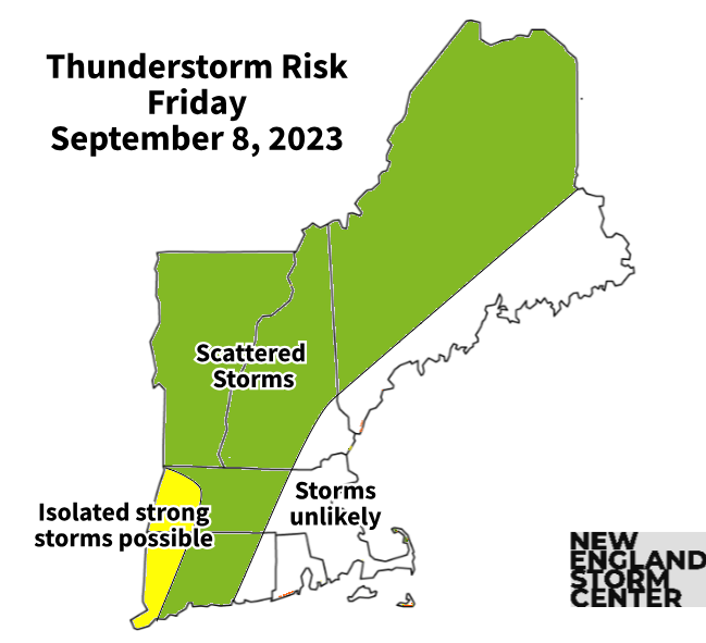
FRIDAY
The thunderstorm threat will shift a bit further east on Friday as the system continues its very slow push toward the region. A more southerly flow ahead of the system will support more cloud cover. This will make it more difficult for temperatures to reach the levels on Thursday. Highs will likely top out in the 80s for most, with some areas potentially getting to 90 in southern New England.
Timing of the thunderstorms will be typical, with storms firing up in the mid afternoon and continuing through the evening before dying down after sunset.
WEEKEND
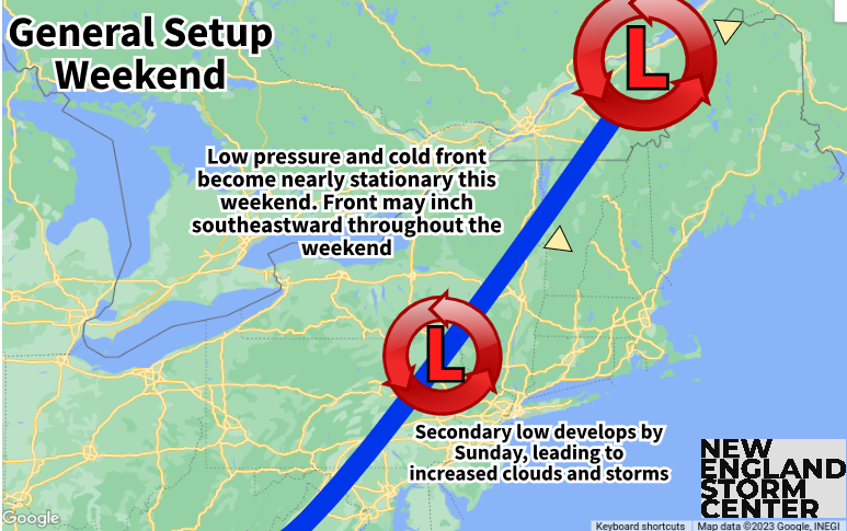
The system to our west finally makes it into northern New England this weekend, but will likely become stationary (or nearly stationary). The northern third of New England will see the most clouds and shower activity during this time. Southern and central New England will likely see multiple rounds of thunderstorms as the weather will remain unsettled and active ahead of the cold front.
Unlike Thursday and Friday, the weekend will see the entirety of New England at risk for thunderstorms. Saturday will be partly to mostly cloudy with afternoon storms firing. The day will not be a washout. Northern areas that are behind the cold front will see mainly overcast skies with on and off showers and storms throughout the day.
ICON showing unsettled weather Saturday afternoon, mainly focused across interior areas:

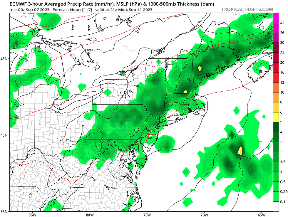
Sunday, a secondary low will likely develop along the sluggish cold front. This will lead to an increased number of showers and storms during the day on Sunday. The day will be mainly cloudy with potentially multiple rounds of storms firing up throughout the day. This doesn't automatically mean the day will be washed out, but multiple rounds of storms and showers can be expected with dry times in between. Like Saturday, areas behind the front will see occasional showers.
Temperature-wise, the cool-down will begin over the weekend. Thanks to cloudy, unsettled weather, highs behind the front will be in the low to mid 70s for northern New England. Central and southern New England, that are still ahead of the front, will climb to the low to mid 80s on Saturday and the upper 70s to low 80s on Sunday. Overnight lows will remain arm as dew points remain elevated. This will also lead to continued humid conditions this weekend despite the lower temperatures.
MONDAY
Monday will be similar to Sunday as the cold front continues to push through the region. It's likely going to take a good three days for this cold front to push through all of New England. The day will likely see lots of clouds and continued scattered showers and storms. Highs will be in the 70s just about region-wide.
Euro showing continued showers on Monday:
BEYOND
The front will finally have cleared the region by Tuesday, but it will still be nearby. The day is trending drier, but showers can't be ruled out. Unsettled weather looks to pick up again by mid-week as the next system approaches from the west. Widespread rain will be possible for portions of the region, but overall coverage of rain and rainfall intensity remains to be determined.
Euro showing the next system coming next week. With a week to go, much still needs to be determined. Don't take this as being set in stone:

TRACKING THE TROPICS
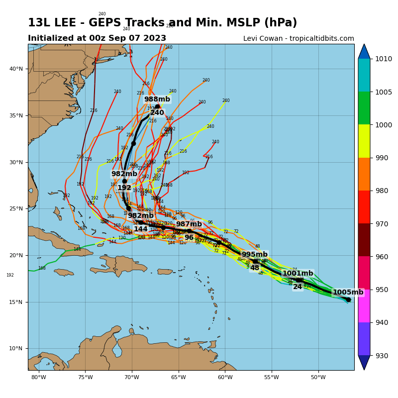
Hurricane Lee is set to become a major hurricane, potentially reaching category four status as early as Friday. The storm is heading west-northwest, toward the Bahamas. The storm will very likely begin to curve northward and parallel the east coast. Lee will very likely remain offshore of the United States. It will likely pass New England by the end of next week. Models (naturally) vary with placement of the storm this far out. Being over a week out, you can't really take models all that seriously yet. It's something to continue to monitor.
This is looking a week and a half out, these will change:
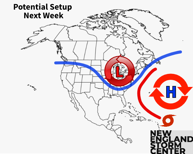
The potential set up for next week, aiding to keep the storm offshore:
Comments