Frontal Boundary to Bring Rain, Snow, Ice to New England This Weekend
- Tim Dennis
- Mar 27
- 5 min read
Heading into this weekend, the weather setup will be a mess, very typical of springtime in New England. An extended period of unsettled weather with multiple waves of precipitation looks likely. This will come as a frontal boundary stalls over or just to the south of New England. This boundary will be sandwiched between an area of high pressure over Quebec and another one over the Atlantic to the south of New England. This is a perfect setup for a variety of precipitation types across the region.
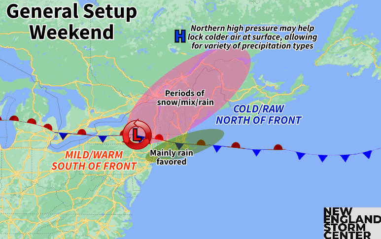
With an area of high pressure set up to the north of New England, it could keep cold temperatures locked at the surface while the air aloft warms as a southerly flow develops around the southern, offshore high. This means every precipitation type (rain, snow, sleet, freezing rain and graupel) will be possible across New England from Saturday through Monday. The frontal boundary will decide where surface temperatures remain locked in the 30s and 40s and where mild temperatures will reach the surface.
Tracking this boundary, a cold front is poised to drop through New England on Friday. There won't be much of an air mass change behind this passage. A strong westerly flow will actually allow temperatures to climb a notch higher than Thursday in southern and central New England. As this boundary stalls out Friday night and Saturday, a significant temperature contrast will likely set up. Cold air will drain from Canada to the north of the front while mild air surges to the south of it.
Below: Temperature departure from average Saturday afternoon:

There will likely be a 40+° temperature difference across New England for highs Saturday. While that is indeed a decent temperature gradient across the 200 miles from Hartford, Connecticut to Berlin, New Hampshire, the gradient will be much sharper than that. There could be a 30-40° difference just from Hartford to Fitchburg. Exactly where the cutoff occurs will depend on exactly where the front decides to set up. It does look like it will set up across southern New England, possibly right through Massachusetts.
There are still the possibilities for trends to the south or north. With the expected temperature contrast, any shifts could lead to big temperature busts for Saturday afternoon. Given the expected air mass with a shallow layer of cold air at the surface and the potential for cold air damming, it's much more likely that the front would trend farther south rather than farther north. This means there is a better chance for southwest New England to trend colder rather than mild temperatures farther north and east.
Below: Euro showing potential temperature Saturday afternoon:

On the precipitation side, the heaviest and most widespread precipitation will likely fall on the northern periphery of the low pressure system riding along the front for Saturday. This will likely arrive early Saturday morning and slide west to east through the day. The system will likely be all rain for southern New England with snow showers across northern New England. A rain/snow line will likely move northward through the day as daytime heating occurs.
There will be the potential for moderate to heavy snowfall rates where the system remains all snow across the northern third of the region. There will likely be a jackpot zone of 3-6 or 4-8 inches across northern Vermont, New Hampshire and western Maine. There will likely be a sharp cutoff in snow totals moving southward toward southern Maine, the New Hampshire Lakes Region (and points south) and central Vermont. Exactly where this cutoff occurs needs to be monitored.
Below: Current probability of at least 2 inches of snow from Friday evening to Saturday evening:
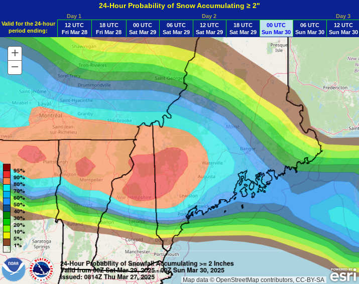
There remain strong indications of cold air damming across all of northern New England and potentially along the higher elevations of southern New England. This will help keep colder air locked at the surface and will likely allow for a wider area of a wintry mix or freezing rain and sleet mixing with plain rain. As always, it's difficult to say just how much freezing rain vs sleet will fall as well as how far inland/north a transition to plain rain gets. There is the potential for accumulating freezing rain and icing.
Below: Current probability of at least a tenth of an inch of ice Saturday morning through Sunday morning:
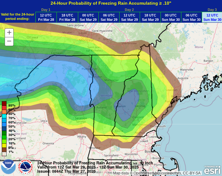
Across southern New England, mainly rain is expected. With the heavier and more widespread precipitation rates expected on the north side of the low pressure, more scattered activity is expected Saturday afternoon as opposed to an all-day washout type of scenario. The farther south you go, the less by way of shower activity is likely. Areas that get fully into the warm sector (Connecticut, western Massachusetts) may even see some breaks in the clouds (though this is far from guaranteed).
Below: Potential weather early Saturday morning (1st image) and early Saturday afternoon (2nd image):
A renewed wave of energy looks to push in later Sunday. It currently looks like the boundary will waffle back southward, allowing areas that got into the warm sector on Saturday to cool back off and join the rest of New England in the cool and raw feel. With the same general setup in place, continued mixed precipitation is likely. Warm air aloft will continue to push north through New England while surface features (high pressure over Canada and the front moving south) will help keep colder air at the surface.
Below: Graphic showing how cold air damming works, which is likely to set up as this weekend progresses for interior northern New England:
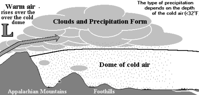
This is a prime setup for a wide area of freezing rain and sleet. There are concerns about potential icing across interior northern New England as the warm nose leads to a gradually deepening layer of warm air aloft while colder air is locked at the surface. With that said, the freezing rain could be more transitional as opposed to dominant.
This would mean a shorter period of freezing rain with more by way of snow/sleet to the north and plain rain to the south. If freezing rain is dominant, that would mean a much longer time would be spent with icing. It's very difficult to say which scenario is more likely this far out. Southern New England and the northern New England coastal plain currently look to see plain rain showers on Sunday.
Below: Current probability of impactful winter weather Sunday into Monday morning:
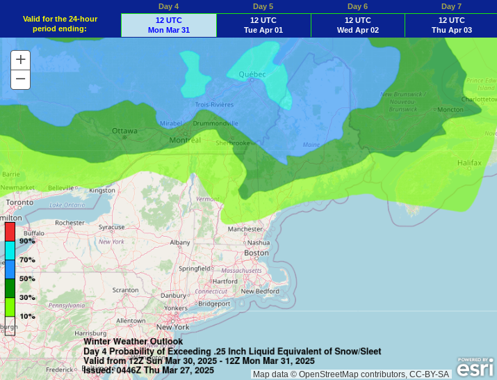
Warm air advection will likely continue to increase from south to north, gradually switching wintry precipitation to plain rain from south to north Sunday night and Monday. This will come as the main low pressure system working eastward across the country lifts through New England, pulling the stalled boundary northward as it does so.
This system looks to clear out by Tuesday morning with high pressure building into the region. The jet stream looks to set up near or over New England through the extended period. This will keep the storm track over New England with another system potentially moving in later next week.


Comments