Five Weather-Defining Moments of 2024 for New England
- Tim Dennis
- Dec 28, 2024
- 8 min read
The year 2024 in New England's weather featured a stormy conclusion to the winter season, a handful of severe storm events in the summer and, in a continuation of 2023's weather, more major flooding events. Here's a look back at some of the notable weather events that came through our region in the last year:

Spring Snow Blitz (March 9-April 5)
The 2023-2024 winter was marked by a strong El-Nino event, which typically favors above average warmth and below average snowfall for New England. For most of the winter this did pan out. On February 25th, we published an article titled "New England Sees Mild Winter With Less Snow (for now)...Which Was Expected." We purposely added that "for now" in the title and ended that article by writing:
"March is a very dynamic month weather-wise for New England that can be especially difficult to predict in the long-range. So, despite what long-range guidance may be showing, we're far from declaring winter weather over for New England."

The hesitance to write off winter early despite long-range guidance seemingly doing so ended up being completely justified. The first storm of this snow blitz came on March 9th-10th, which brought a widespread 8-14" of snow to the mountains. On March 20th, a potent clipper brought another 10+" to northern areas. A couple days later, on March 23rd, a storm brought a large swath of 1-2' of snow with a maximum of 33". A major ice storm also developed along Maine's coastal plain. From April 3rd-5th, the final storm in this barrage brought yet another 1-2' of snow for northern New England.
When all was said and done, the snowfall amounts weren't record breaking or anything like that, but it came as a shock after one of the warmest winters on record for most of New England and far below average snow depth. The maximum amount of snow dropped in New England from these four storms added up to 85", or about 7'. The Green Mountains more or less got hammered in March to the point where Killington Mountain Resort dubbed the month "Miracle March" after a lackluster winter for snowfall.


Photos: Central Maine Power; Josh Barret; WMUR; Unitil
New England Storm Center's coverage of this event when it happened:
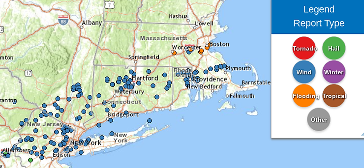
Southern New England's "Pseudo Derecho" (June 26)
During the evening of June 26th, a very powerful line of thunderstorms tore a path from Pennsylvania through southern New England. The official definition of a derecho is "a widespread, long-lived wind storm that is associated with a band of rapidly moving showers or thunderstorms. The squall line needs to travel at least 400 miles and contain frequent gusts of 58mph with several gusts of at least 75mph." This 400 mile threshold was raised from 240 miles in 2022. All of this criteria came true except for the 400 mile threshold. That's why we're calling this a "pseudo" derecho since it has the same effects as an official one.

The threat for severe weather in New England was low coming into this event. This was mainly because the line of storms was set to arrive well after dark, when thunderstorms typically begin to weaken due to the loss of daytime heating and instability. New England had a "marginal" risk of severe weather (level 1 of 5) for the day. The line of storms would not weaken as they moved through southern New England. The high amount of CAPE (instability) and shear was able to overcome the onset of night.
The strongest gust recorded in this line was 77mph in Windsor Locks, Connecticut with a gust reaching 75mph in Danielson. Over a half dozen communities in southern New England saw trees damage buildings. A rare nighttime tornado touched down at 11:23pm in Lincoln, Rhode Island The tornado was rated as an EF-1 with winds estimated at 100mph. The line also caused extensive flash flooding in the Boston Metro area. Numerous reports described widespread tree damage with a handful of homes and cars getting damaged by the falling lumber. Tragically, one was killed in Connecticut by a falling tree.


Photos: NBC Connecticut; National Weather Service; Carlos R. Munoz; Henry's Weather Channel
New England Storm Center's coverage of this event when it happened:
Back-to-Back Major Coastal Flooding (January 10-13)
Two powerful storms struck back to back, both bringing major coastal flooding. The first of these coastal flooding events came from a multi-hazard storm that also brought near hurricane-force wind gusts, 3-5 inches of rain and 6-12 inches of snow. The coastal flooding over-performed, with Portland, Maine seeing their third highest ride on record. A neighborhood in Hampton, New Hampshire was inundated. Evacuations were ordered and an emergency has been declared. Ocean Boulevard was closed and residents in the area were asked to seek higher ground immediately.

Just days later, a historic coastal flooding event unfolded, eclipsing the major flooding seen just three days prior. This event on January 13th was forecast to be historic and significant, and this unfortunately panned out across northern New England. Portland, Maine reached 14.57 feet. This set the new all-time highest tide in Portland's recorded history (high tide records date back to 1912). The entire Maine coastline saw significant water rise resulting in heavy damage.
In Tremont, a dock house was washed away. This house was over 100 years old. Chipman's Wharf in Milbridge has been reported to be destroyed. Castine saw a boatyard under 5-10 feet of water, inundating and damaging structures and vehicles. Most piers in Pigeon Hill Bay have been reported to be destroyed. Old Orchard Beach saw multiple water rescues and electrical fires as the water inundated multiple structures and roads, trapping residents. A flash flood warning was issued Saturday morning for the southern Maine and New Hampshire coasts as ocean water continued to rise while bouts of heavy rain poured down.


Photos: Michelle Erskine; Scarborough Fire Department; WGME; Troy Lynch; Brostol Parks and Rec; Henry's Weather Channel
New England Storm Center's coverage of this event when it happened:
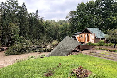
Vermont's Surprise Flash Flood (July 30)
In the early morning hours of Tuesday, July 30th, an extreme rainfall event took place across Vermont's Northeast Kingdom. This event dropped upwards of eight inches of rain across the region in a span of less than eight hours. Furthermore, St. Johnsbury saw nearly a half foot of rain in just six hours. The severity of this storm was a complete shock. There were no flood watches posted as only scattered showers were expected. On July 27th, we published an article titled "Great Weekend With a Slight Nuisance Approaching Sunday Afternoon."

The main piece was a cut off low, which formed into a rare summertime nor'easter. That night, the storm created strong upper-level divergence, which is a sign of storm strengthening; the storm that had been weak quickly became abnormally strong given the time of year. This also allowed storms to continue well into the night. The atmosphere was incredibly moisture-rich, as it has been for most of July. Storms were quickly able to take full advantage of the humidity in the air and produce intense rainfall rates. The cut off nature of the system allowed storms to very slowly move over the Northeast Kingdom.
A rare flash flood emergency was issued for Morgan Center, St. Johnsbury and Danville, Vermont. Swift water rescues and evacuations have been reported in Lyndonville and nearby communities. Vermont Emergency Management reported 10 swift Water Rescue teams have performed about two dozen rescues in the Northeast Kingdom. A shelter in place order was put into effect for Lyndon and St. Johnsbury. The Passumpsic River saw an over 1,000% increase in flow in just six hours. Propane tanks and other debris have been seen floating through the river.


Photos: Lyndon Rescue; St. Johnsbury Police; WCAX; Vermont State Police
New England Storm Center's coverage of this event when it happened:
Connecticut Floods (August 18)
Reminiscent of Vermont's surprise flood, the severity of this one was unexpected as well. The weekend of this flooding saw a very slow moving frontal system set up just to the west of New England. This system was hung up due to an atmospheric traffic jam with high pressure and a distant hurricane preventing the storm's timely movement through the region. The bulk of the rainfall that fateful Sunday was expected just to New England's west, with flood watches posted for the New York-Pennsylvania-New Jersey area. The intense rains ended up setting up just a bit further east, in western Connecticut.

This led to an intense band of training thunderstorms to move over southwest Connecticut for hours on end. At one point, the band of storms was nearly stationary. This brought about a localized albeit severe flooding event. 6-12" of rain fell over at least 18 towns, with the highest total measured in Newtown, where 12.17" fell. This storm was investigated by the National Weather Service and State Climate Extremes Committee for potentially setting a new 24 hour rainfall record for the state. In October, the 14.83" measurement from Oxford was deemed to be erroneous, so the previous record of 12.77" remains in place from 1955.
A flash flood emergency was issued for Fairfield and New Haven counties. This alert is reserved for only the most significant of flooding situations. The flood waters rose within minutes outside the Southbury Plaza, where local citizens helped perform multiple rescues of people trapped within their cars. Many instances of water rescues, evacuations, gas leaks, mud slides, road washouts and other instances of heavy damage. Many cars were swept away and abandoned on the road as the severity of the storm caught many by surprise. Tragically, two were killed after being swept into the Little River while a rescue was being attempted.


Photos: Matt Austin; NBC Connecticut; Zander Sahilia; Maybe K*RK; Jack Drake; Connor Dinallo
New England Storm Center's coverage of this event when it happened:
Other events considered: Fall wildfires (October 21-November 21); Anniversary flood (July 10-11); Mid-February snowstorm bust (February 13); Winter storm warnings to flood warnings (January 6-10)
NEW ENGLAND STORM CENTER ON NEWSBREAK
In 2024, New England Storm Center passed the 500,000 view milestone on the NewsBreak app and NewsBreak.com. Here's a look at some of our most read articles this past year:
Tornado confirmed during last night's storms as recovery continues (published June 27)
Nor'Easter Takes Southward Trend; What We're Expecting and Why it Happened (Published February 12)
Early look at potential storm next week for New England (Published March 30)
Beryl's remnants to bring heavy rain to New England: Impacts, timing (Published July 10
Thank you for the continued support; we're set and ready to continue our weather coverage through 2025!
Comments